Conservation Committee
Wednesday, March 28, 2012
9:00 a.m.
Texas Parks and Wildlife Department
Commission Hearing Room
4200 Smith School Road, Austin, TX 78744
Chairman T. Dan Friedkin, Committee Chair
Scott Boruff, Committee Liaison
Approval of Previous Meeting Minutes
- Update on TPWD Progress in Implementing the TPWD Land and Water Resources Conservation and Recreation Plan
- Internal Affairs Report
- Edwards Aquifer Recovery Implementation Program (RIP) and Designation of a State Scientific Area – Recommended Adoption of Proposed New Rules (Action Item No. 2)
Staff: Cindy Loeffler, Colette Barron Bradsby - Acceptance of Land Donation - Cameron County – 10 Acres at the Ebony Unit at the Las Palomas Wildlife Management Area – Request Permission to begin the Public Notice and Input Process
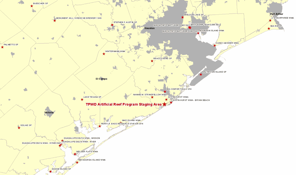
Staff: Corky Kuhlmann - Land Sale – Brazoria County – Approximately 2.5 Acres along the San Bernard River – Request Permission to begin the Public Notice and Input Process
Staff: Corky Kuhlmann - ITEM WITHDRAWN — Land Acquisition – Brazoria County – 480 Acres at the Christmas Bay Coastal Preserve – Request Permission to begin the Public Notice and Input Process
Staff: Ted Hollingsworth - Land Acquisition – Coryell County – Acquisition of Approximately 142 Acres at Mother Neff State Park – Request Permission to begin the Public Notice and Input Process
Staff: Ted Hollingsworth - Acceptance of Land Donation – Aransas County – Approximately 80 Acres at the Big Tree area at Goose Island State Park – Request Permission to begin the Public Notice and Input Process
Staff: Ted Hollingsworth - Request for Easement – Harris County - Hydrocarbon Pipelines at San Jacinto Battleground State Historic Site - Request Permission to begin the Public Notice and Input Process
Staff: Ted Hollingsworth - Water Distribution Pipeline Easement at Monahans Sandhills State Park – Ward and Winkler Counties (Executive Session)
Staff: Ted Hollingsworth
Committee Agenda Item No. 1
Presenter: Carter Smith
Conservation Committee
Update on TPWD Progress in Implementing the
TPWD Land and Water Resources Conservation and Recreation Plan
March 28, 2012
I. Executive Summary: Executive Director Carter Smith will briefly update the Commission on the status of the agency’s efforts to implement the Land and Water Resources Conservation and Recreation Plan (the “Plan”).
II. Discussion: In 2001, the 77th Texas Legislature directed that the Texas Parks and Wildlife Department (TPWD) develop a Land and Water Resources Conservation and Recreation Plan (Tex. Park & Wild. Code §11.104). In 2002, the Texas Parks and Wildlife Commission (the Commission) adopted the first Plan. A revised Plan was adopted by the Commission in January 2005. In November 2009, the Commission approved a new Plan effective January 1, 2010. The 2010 Plan is available on the TPWD web site. Executive Director Carter Smith will update the Conservation Committee on TPWD’s recent progress in achieving the Plan’s goals, objectives and deliverables.
The Plan consists of the following four goals:
- Practice, Encourage and Enable Science-based Stewardship of Natural and Cultural Resources
- Increase Access To and Participation In the Outdoors
- Educate, Inform and Engage Texas Citizens in Support of Conservation and Recreation
- Employ Efficient, Sustainable and Sound Business Practices
Committee Agenda Item No. 3
Presenter: Corky Kuhlmann
Conservation Committee
Land Donation – Cameron County
Ebony Unit at the Las Palomas Wildlife Management Area (WMA)
March 28, 2012
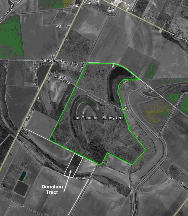
I. Executive Summary: Texas Parks and Wildlife Department (TPWD) has been offered a donation of approximately 10-acres of land in Cameron County.
II. Discussion: TPWD has been offered a donation of an approximate 10-acre tract of land (Tract) located just south of and across Pecan Road from the Ebony Unit of the Las Palomas WMA
The Tract is heavily populated with native vegetation. Because of the thickness of the brush, hunting will most likely be an option, with its best value being to provide habitat for resident and migratory birds
Staff would like to begin the process of providing public notice and obtaining public input regarding a proposed donation of the 10-acre tract.
Committee Agenda Item No. 3
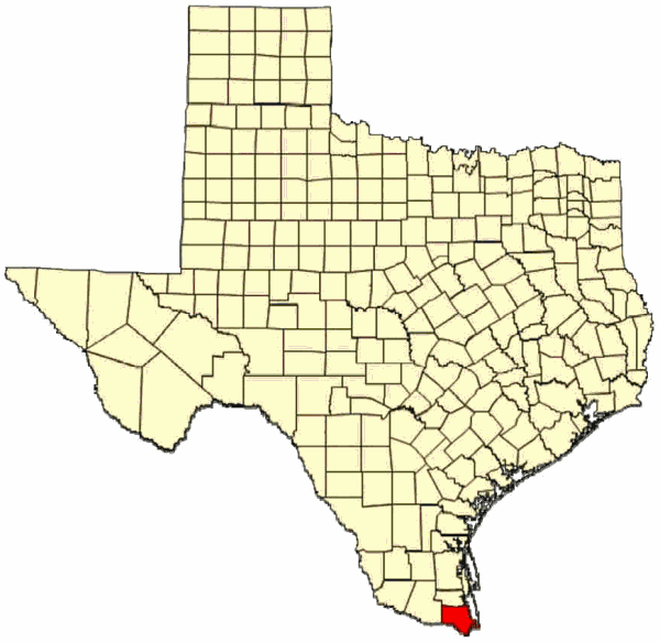
Exhibit A
Location Map
Cameron County
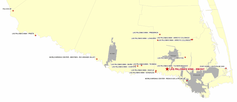
Committee Agenda Item No. 3
Exhibit B
Vicinity Map
Ebony Unit
Las Palomas WMA
Committee Agenda Item No. 3
Exhibit C
Site Map
Ebony Unit
Las Palomas Wildlife Management Area
Committee Agenda Item No. 4
Presenter: Corky Kuhlmann
Conservation Committee
Land Sale – Brazoria County
March 28, 2012
I. Executive Summary: Texas Parks and Wildlife Department staff (TPWD) is seeking approval to sell approximately 2.44 acres along the San Bernard River in Brazoria County.
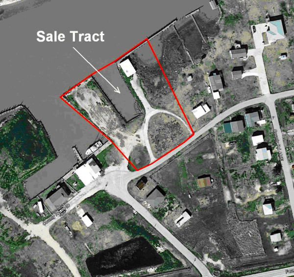
II. Discussion: In 2003, the TPWD Artificial Reef Program purchased 2.44 acres in Brazoria County with the intention of using the property for the storage of artificial reefing materials. The property is located on the San Bernard River, has a fishing pier, boat basin, and steel bulkheads. Shortly after obtaining the property, the San Bernard River silted-in (entrance/exit to the Gulf of Mexico) making boat/barge traffic difficult. The river was dredged by the U.S. Army Corps of Engineers several years later but continues to silt-in on a regular basis. In 2011, the Artificial Reef Program (working through TPWD Infrastructure Division) contracted for a feasibility study to improve the property for storage of reefing materials. The results of this study concluded that the intended use of this site is not feasible.
Staff would like to begin the process of providing public notice and obtaining public input regarding the sale of approximately 2.44 acres of land along the San Bernard River.
Committee Agenda Item No. 4
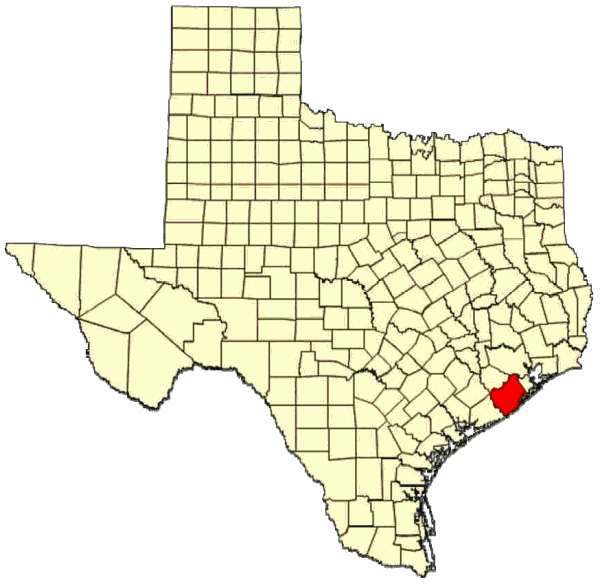
Exhibit A
Location Map
Brazoria County
Committee Agenda Item No. 4
Exhibit B
Vicinity Map
Artificial Reef Program Tract
Committee Agenda Item No. 4
Exhibit C
Site Map
Artificial Reef Program Tract
Committee Agenda Item No. 6
Presenter: Ted Hollingsworth
Conservation Committee
Land Acquisition – Coryell County
Approximately 142 Acres at Mother Neff State Park
March 28, 2012
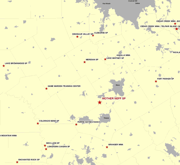
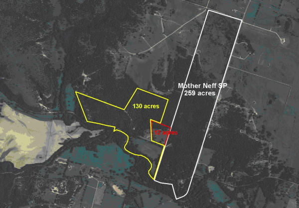
I. Executive Summary: TPWD staff has negotiated an option to purchase approximately 142 acres of land with high quality natural and cultural resources adjacent to Mother Neff State Park in Coryell County.
II. Discussion: Mother Neff State Park was the first official state park in Texas, named for Mrs. Isabella Eleanor (Mother) Neff who donated six acres of land along the Leon River in 1916. After the death of his mother in 1921, Governor Pat Neff created the Mother Neff Memorial Park which later became the nucleus of the Texas State Park System. The Civilian Conservation Corps developed and constructed facilities on the park in the mid 1930’s. Located close to Temple and Waco, the park is popular, but limited by its relatively small size of 259 acres.
Two adjacent landowners have been working with TPWD staff to sell their properties to TPWD for addition to the park. These two tracts, totaling approximately 142 acres, would add forest habitat, impressive views, a significant spring, a half mile of frontage of the Leon River, and extensive prehistoric archeological resources to the park, providing for greatly expanded recreational and interpretive opportunities.
Staff requests permission to begin the public notice and input process associated with the acquisition of approximately 142 acres in Coryell County.
Committee Agenda Item No. 6
Exhibit A
Location Map for Mother Neff State park in Coryell County

Committee Agenda Item No. 6
Exhibit B
Vicinity Map for Mother Neff State Park 15 miles Northwest of Temple
Committee Agenda Item No. 6
Exhibit C
Site Map for Subject Tracts at Mother Neff State Park
Subject 142 Acres Outlined in Red and Yellow
Committee Agenda Item No. 7
Presenter: Ted Hollingsworth
Conservation Committee
Acceptance of Land Donation – Aransas County
Approximately 80 Acres at Goose Island State Park
March 28, 2012
I. Executive Summary: The Nature Conservancy (TNC) is pursuing funding for the acquisition and transfer of critical habitat for the endangered Whooping Crane adjacent to the Big Tree at Goose Island State Park to Texas Parks and Wildlife Department (TPWD).
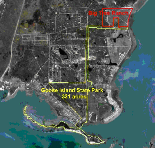
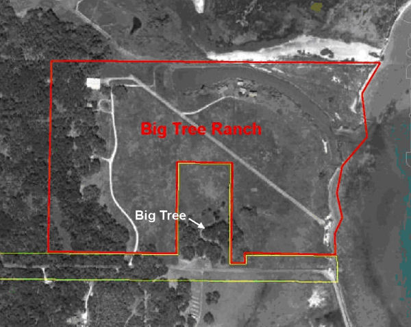
II. Discussion: Goose Island was acquired in 1931 for development as a Civilian Conservation Corps park. Over the next few years, a small tract, a little over a mile away, including an immense live oak known as “The Big Tree” was acquired, along with a 200’ wide strip of land to serve as a scenic corridor between the two sites. Since then, the two parts of Goose Island State Park have been connected by Park Road 13 (PR 13), also known as Palmetto Street. The five-acre Big Tree tract is surrounded by private property known as the “Big Tree Ranch.” Long-term health of the Big Tree and the visitor experience to the Big Tree has always been at risk from the prospect of development of the Big Tree Ranch.
Big Tree Ranch has been identified as critical habitat for the endangered Whooping Crane, and cranes are seen regularly on the property and in wetlands adjacent to the property. The ranch to the north of Big Tree Ranch is already protected by a conservation easement. TPWD and TNC have been collaborating for several years on efforts to obtain funding for the acquisition of the Big Tree Ranch. A possible source of funding to acquire this property has recently materialized, and should that occur TNC intends to acquire the property and transfer it to TPWD to be managed and operated as part of Goose Island State Park. Staff requests permission to begin the public notice and input process.
- Attachments — 4
- Exhibit A – Location Map
- Exhibit B – Vicinity Map
- Exhibit C – Subject Tract Map
- Exhibit D – Site Map
Committee Agenda Item No. 7
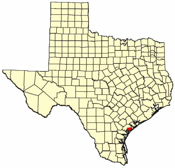
Exhibit A
Location Map for Goose Island State Park in Aransas County
Committee Agenda Item No. 7
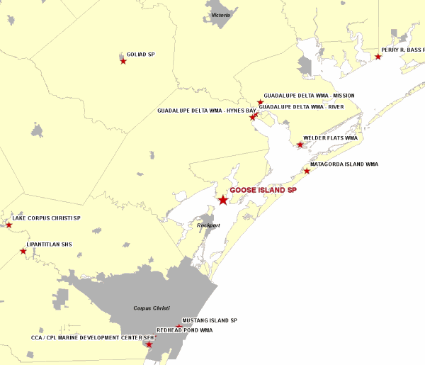
Exhibit B
Vicinity Map for Goose Island State Park, 8 Miles North of Rockport
Committee Agenda Item No. 7
Exhibit C
Map Showing Relation of Subject Tract to Goose Island State Park
Committee Agenda Item No. 7
Exhibit D
Site Map Showing the Big Tree and Big Tree Ranch
Committee Agenda Item No. 8
Presenter: Ted Hollingsworth
Conservation Committee
Request for Easement – Harris County
Hydrocarbon Pipelines at San Jacinto Battleground State Historic Site
March 28, 2012
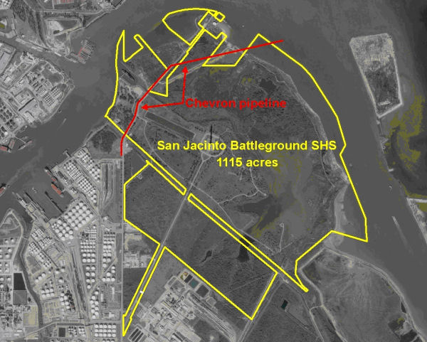
I. Executive Summary: Chevron Pipe Line Company requests amendment of an existing pipeline easement that crosses the San Jacinto Battleground State Historic Site (San Jacinto) for the purpose of adding two (2) transmission pipelines.
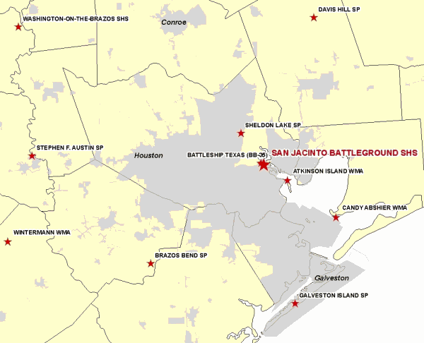
II. Discussion: San Jacinto, located 20 miles east of downtown Houston, consists of just over 1,000 acres, centered on the campsites and primary field of battle where a volunteer Texan army defeated a numerically superior Mexican army to wrest independence from Mexico on April 21, 1836.
Today San Jacinto is located in the heart of the petrochemical refining complexes of Baytown, Deer Park, Pasadena and La Porte. As a result, numerous pipelines, located in several corridors, have crossed the site for many decades. Staff has worked diligently over the years to confine these corridors to small areas and minimize impacts to resources, operations and aesthetics.
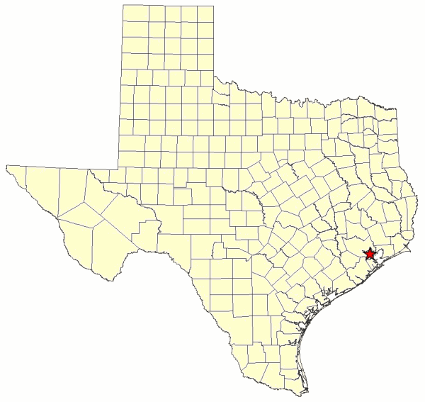
Committee Agenda Item No. 8
Exhibit A
Location Map Showing the Location of San Jacinto Battleground in Harris County
Committee Agenda Item No. 8
Exhibit B
Vicinity Map Showing San Jacinto Battleground, 20 Miles East of Houston
Committee Agenda Item No. 8
Exhibit C
Site Map Showing Route and Location of Requested Pipeline Easement
Committee Agenda Item No. 9
Presenter: Ted Hollingsworth
Conservation Committee
Water Distribution Pipeline Easement at Monahans Sandhills State Park
March 28, 2012
I. Executive Summary: The Colorado River Municipal Water District has responded to terms and conditions of a draft lease authorized by the TPW Commission in November 2011.
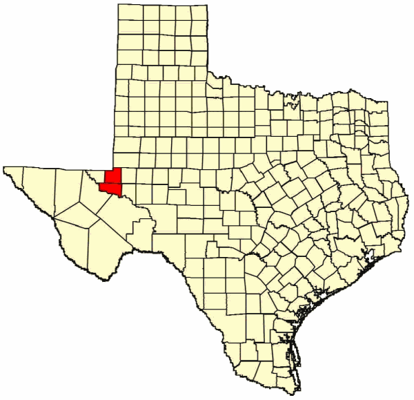
II. Discussion: Monahans Sandhills State Park (SP) covers 3,840 acres straddling Ward and Winkler counties southwest of Odessa. As the name implies, the park preserves an excellent example of arid land sand dunes, some up to 70 feet high. The site protects a range of resources such as an important archeological site and the Dunes sagebrush lizard, a candidate species for federal listing.
The park has been managed and operated since 1956 under a long-term lease from the Sealy and Smith Foundation (Foundation) of Galveston. In 1971 the Colorado River Municipal Water District (CRMWD) obtained an easement from the Foundation and installed a 33-inch waterline through the state park in Ward County. The CRMWD supplies water to Odessa, Snyder and Big Spring. Due to growth in these communities since 1971, and the strain on water supplies precipitated by the current drought, CRMWD wishes to install a second pipeline of 48 inches parallel to the existing line. They would like to begin construction in January 2012.
In November 2011, the TPW Commission passed a resolution authorizing the Executive Director “to take all necessary steps to negotiate terms and conditions under which TPWD concurs with the granting of an Easement, and to provide those terms and conditions to the Foundation with a recommendation that an Easement be granted to CRMWD for the purposes and subject to the conditions described herein and in the motion approved in this Resolution.” Land Conservation and Legal staff will brief and discuss with the Commission in Executive Session the real estate and legal issues associated with this matter.
Committee Agenda Item No. 9
Exhibit A
Location Map for Monahans Sandhills SP in Ward and Winkler Counties
Committee Agenda Item No. 9
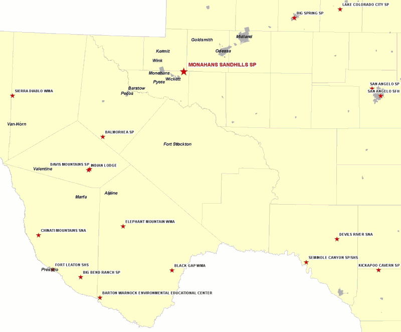
Exhibit B
Vicinity Map for Monahans Sandhills SP 30 miles Southwest of Odessa
Committee Agenda Item No. 9
Exhibit C
Site Map for Requested Easement at Monahans Sandhills SP
