- Table of Contents
- Foreword
- Introduction
- Texas Waterway Map
- Map Key
- East Texas Waterways
- Central Texas Waterways
- Major Waterways:
- Blanco River
- Bosque River
- Brazos River
- Colorado River
- Concho River
- Frio River
- Guadalupe River
- Lampasas River
- Lavaca River
- Leon River
- Little River
- Llano River
- Medina River
- Navidad River
- Nueces River
- Paluxy River
- Pedernales River
- San Antonio River
- San Bernard River
- San Gabriel River
- San Marcos River
- San Saba River
- Wichita River
- Seasonal and Restrictive Waterways
- Major Waterways:
- West Texas Waterways
An Analysis of Texas Waterways
A Report on the Physical Characteristics of Rivers, Streams, and Bayous in Texas
Major Waterways of Central Texas
Brazos River
The Brazos River is the largest river between the Rio Grande and the Red River has a total length of about 840 miles from the source of its longest fork. The river flows through most of the major physiographic regions of Texas. The Brazos has three upper forks: the Double Mountain, the Salt Fork, and the Clear Fork. Of the three forks, only the Clear Fork has potential for recreational use on a year-round basis. The main Brazos River begins at the junction of the Double Mountain and Salt Forks in Stonewall County. However, the river has insufficient water for recreational use until the Clear Fork enters the main stream in Young County. Three major reservoirs are located on the main stream, and the best sections for recreation are found below Possum Kingdom Dam. Few major hazards are found on the entire river.
Clear Fork
Jones, Shackelford, Throckmorton, Stephens and Young Counties
The Clear Fork of the Brazos, formed in Fisher County, flows 180 miles northwest to join the main stream of the Brazos in Young County. The section of the Clear Fork in Jones, Shackelford, Throckmorton, Stephens, and Young Counties is characterized by muddy water, steep banks, and low overhanging willow, pecan, and elm trees. The flood plain generally is utilized for farming and ranching, but these activities are not normally noticeable from river level because of steep banks. Except during periods of heavy rainfall, the river moves slowly. A small three-foot waterfall is located one mile upstream from US 180 crossing. Between US 180 and US 380, a lake of about 4 miles in length is formed by a small dam. Immediately below the dam, there exists a series of dangerous stairstepped falls where the water flows over two rock ledges, approximately 20 feet in height. These falls require a portage. Below the dam and the falls, the river is scenic, passing through the heart of a rolling hills and ranch country of West Central Texas.
Double Mountain Fork
Garza, Kent, Fisher, Stonewall and Haskell Counties
The Double Mountain Fork of the Brazos River, formed near Tahoka in Lynn County, flows east for approximately 150 miles to junction with the Salt Fork, forming the main stream. This river flows through isolated ranching and farming country, with little development present. During periods of normal flow the river is extremely shallow and meanders within its stream bed. Whenever there is sufficient rainfall to cause a rise, the water level is adequate for recreational use. Extreme care is necessary during periods when heavy rainfall is anticipated because of the danger of flash floods. The area around Double Mountain in southeastern Stonewall County is a scenic section which typifies the ranchland environment of North Central Texas.
Salt Fork
Kent and Stonewall Counties
The Salt Fork of the Brazos River, formed in southeastern Crosby County, flows southeast for about 175 miles to join the Double Mountain Fork in Stonewall County, forming the main stream. The Salt Fork is intermittent and very shallow at normal water levels. Meandering across a wide stream bed which contains many large sand bars, the Salt Fork usually has insufficient water for recreational use unless heavy rains cause a rise. During these heavy rains, flash floods are common. Water during these periods is normally muddy and contains high concentrations of salty, brackish minerals.
Brazos River, Main Stream
Confluence of Salt and Double Mountain Forks to Possum Kingdom Reservoir
(Not mapped)
150 miles
The main stream of the Brazos River is formed in northeastern Stonewall County by the confluence of the Salt and Double Mountain Forks. The main stream flows approximately 150 miles before it is backed up by the dam at Possum Kingdom Reservoir. The upper reaches of the main stream do not normally have sufficient water for recreational use until the Clear Fork adds its flow in Young County. Therefore, only the small section (approximately 25 miles) between the confluence with the Clear Fork and the back-up waters from Possum Kingdom Reservoir generally has sufficient water for recreational purposes. The upper reaches of the main stream pass through semi-arid farming and ranching country. Here, the river meanders within its own streambed, depositing large sand bars between the steep banks.
Brazos River
Possum Kingdom Dam to US 180
41.4 Miles
Possum Kingdom Dam to US 180
41.4 miles
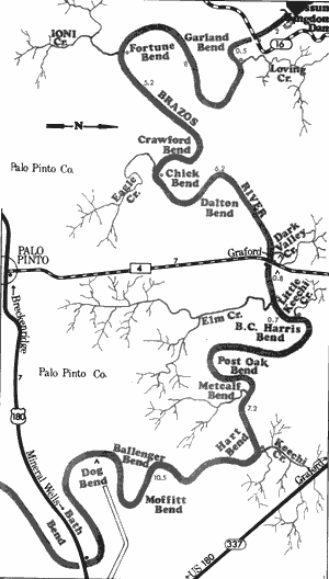
This 41.4-mile section of the Brazos River in Palo Pinto County is one of the most scenic that the Brazos has to offer. The river flows through the heart of the Palo Pinto Country, an area consisting of beautiful cedar-covered hills and mountains where Comanches once roamed. This country is rugged, rocky, and isolated with very little development. Generally the river is extremely wide and scenic with heavily vegetated banks consisting of elm, willow, oak, and cedar, along with spectacular outcroppings of rock, high bluffs, and views of the Palo Pinto Mountains. There are many gravel bars and islands which often lend themselves to camping and day use along the upper portions of this section. Sand bars become more common farther downstream. With only three road crossings on this section, points of access are a problem and steep banks provide a further hindrance.
The suitability of this section of the Brazos for recreational use depends upon water being generated from Possum Kingdom Dam. The water coming from the dam is cold and clear. A common occurrence for the river is the rising of 2 or 3 feet in a matter of minutes when the dam is generating. If the dam is not generating, the river is relatively shallow which results in the river being difficult to float. A couple of good rapids, one located beneath the FM 4 bridge, are found on this section during high water. Waterway features and distance between each are as follows:
Brazos River Authority land - located
immediately below Possum Kingdom
Dam. This land is open to the public,
but no facilities are provided.
SH 16 crossing - 2 miles below Possum
Kingdom Dam. A small area below the
crossing provides good access. (2 miles)
Loving Creek - enters on the left. (0.5 mile)
Ioni Creek - enters on the right. (8 miles)
Eagle Creek - enters on the right. (5.2 miles)
Dark Valley Creek - enters on the left.
(6.2 miles)
Private Camp - located just upstream from
FM 4 crossing. (0.1 mile)
FM 4 crossing - 7 miles north of Palo Pinto.
There would be no access from the
bridge. (0.1 mile)
Private Camp - located just downstream
from FM 4 crossing on the left. Access
to the river is often obtained on a private
road for a small fee. (0.1 mile)
Elm Creek - enters on the right. (0.8 mile)
Little Keechi Creek - enters on the left.
(0.7 mile)
Keechi Creek - enters on the left. (7.2 miles)
Private camp - enters west of Mineral Wells
on a county road off US 180. Picnic tables
are provided and overnight camping is
permitted. (6.5 miles)
US 180 crossing - 3 miles west of Mineral
Wells. Access is fairly limited. (4 miles)
Brazos River
US Highway 180 to US Highway 281
35.2 Miles
US Highway 180 to US Highway 281
35.2 miles
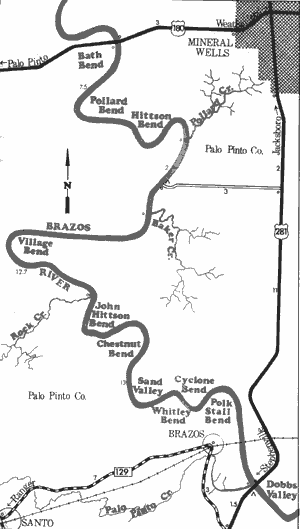
This 35-mile section of the Brazos River in Palo Pinto County is very similar to the preceding section. Cedar-covered hills and mountains, scenic vistas, and precipitous shorelines are still very much in existence. Vegetation along the river bank remains thick and water quality is relatively high. The river banks are clean and unpolluted.
No road crossings exist between the two US Highways at the start and end of this section and the banks are steep at the crossings. Many small islands which often lend themselves to camping and day use exist, and the number of sand bars increases as the river progresses downstream. Some rapids can be found on this section; however, none of them are serious hazards to recreational use.
The best water levels for recreational use of this section exist a day or so after Possum Kingdom Dam has been generating. This allows the water plenty of time to travel the distance between the dam and US 180. If the dam is not generating, many shallow areas are likely found. Waterway features and distance between each are as follows:
US 180 crossing - 3 miles west of Mineral
Wells. The right of way surrounding the
high bridge provides poor access.
Pollard Creek - enters on the left. (7.5 miles)
Private camp - 3.5 miles southwest of Mineral
Wells off US 281 on a gravel road. An
extensive shoreline is available for use,
but no facilities are provided. Camping is
permitted. (1 mile)
Baker Creek - enters on the left. (1 mile)
Rock Creek - enters on the right. (12.7 miles)
Palo Pinto Creek - enters on the right.
(12.8 miles)
US 281 crossing - 13 miles south of
Mineral Wells. (0.2 mile)
Private camp - located adjacent to US 281
crossing. Good access is available, and
camping and picnicking facilities are
provided.
Brazos River
US Highway 281 to Farm-to-Market 1884
41 Miles
US Highway 281 to Farm-to-Market 1884
41 miles
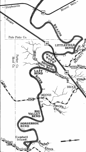
The Brazos River along this 41-mile section on Palo Pinto and Hood Counties has left the rough terrain of the Palo Pinto Mountains and flows through decreasingly rugged country enroute to Lake Granbury. The river becomes a slow, meandering stream with many bends and twists. However, the Brazos remains scenic, flowing through rolling hills and wooded bottomlands of the Cross Timbers Area of North Central Texas. The river is very wide and in places is shallow, but it has been determined that recreational usage is possible during normal and above normal water levels almost year round. Sand bats which often lend themselves to camping and day use are plentiful. There are no potentially dangerous places on this section. The river is divided into 3 relatively equal sections by 4 road crossings. Waterway features and distance between each are as follows:
US 281 crossing - 13 miles south of Mineral Wells.
Private camp - located adjacent to US 281 crossing. Good access is
provided, and camping and picnicking facilities are available.
Rock Creek - enters on the left. (9.5 miles)
Private camp - located adjacent to IH 20, 14 miles southwest of Weatherford.
Access is available, but no facilities are provided. (2.7 miles)
Private camp - located adjacent to IH 20, 14 miles southwest of Weatherford.
This camp is across the river from the previous site. Access is available,
but no facilities are provided. (0.0 mile)
IH 20 crossing - 14 miles southwest of Weatherford. (0.1 mile)
Private camp - located immediately downstream from IH 20, 14 miles southwest
of Weatherford. Access is available, but no facilities are provided. (0.1 mile)
Grindstone Creek - enters on the left.
(4.1 miles)
Hill Creek-enters on the right. (2.4 miles)
Private camp - adjacent to FM 1543, 11 miles
southwest of Weatherford at Dennis.
Access is available but no facilities are
provided. (8.3 miles)
FM 1543 crossing - 11 miles southwest of
Weatherford at Dennis. (0.1 mile)
Patrick Creek - enters on the left. (0.9 mile)
Sanchez Creek - enters on the left.
(11.3 miles)
Private camp - 13 miles south of Weatherford,
adjacent to FM 1884. Access is available,
but no facilities are provided. (1.4 mile)
FM 1884 crossing - 14 miles south of
Weatherford. (0.1 mile) Approximately
4 miles downstream, the Brazos River
enters Lake Granbury.
Brazos River
De Cordova Bend Dam to Whitney Recreation Area
39 Miles
De Cordova Bend Dam to Whitney Recreation Area
39 miles
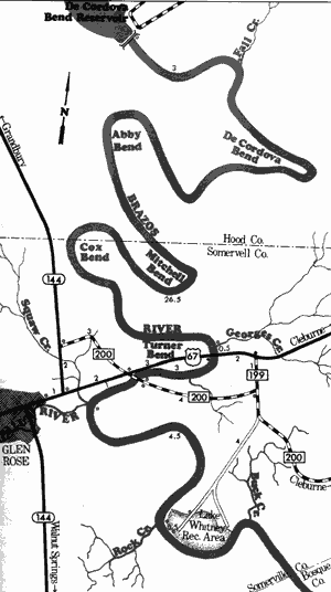
Flowing through Hood and Somerville Counties, this 39-mile section of the Brazos River depends upon water being generated from De Cordova Bend Dam before recreational use is possible. During periods when the dam is not generating, water levels are shallow until the backwaters of Lake Whitney are reached. Water below the dam is clean and clear.
The river along this section is very scenic, flowing through heavily vegetated rolling hills covered with cedar, live oak, and post oak. The river does not run swiftly, but meanders leisurely over sand and rocks. Several limestone outcroppings are present, particularly in the vicinity of the Paluxy River. The Paluxy is a tributary of the Brazos and is a small but picturesque river which has potential for recreational use. No potentially hazardous places are found along this section of the Brazos and the river is fairly accessible, especially on the lower portion. Waterway features and distance between each are as follows:
De Cordova Bend Dam - 8 miles southeast
of Granbury.
Fall Creek - enters on the left. (3 miles)
Georges Creek - enters on the left.
(26.5 miles)
US 67 crossing - 5miles east of Glen Rose.
(0.5 mile)
FM 200 crossing - 3 miles northeast of Glen
Rose. (3 miles)
Paluxy River - enters on the right. (1 mile)
Rock Creek - enters on the right. (4.5 miles)
Lake Whitney Recreational Area - 7 miles
southeast of Glen Rose. Camping and
picnicking facilities are available. The
river has now entered the backwaters
of Lake Whitney. (0.5 mile)
Lake Whitney Recreational Area extends up the Brazos River from Lake Whitney for approximately 36 miles. Recreational use of the river for this 36-mile distance is feasible, giving a total length of approximately 66 miles of potential recreational waterway from De Cordova Bend Dam to Lake Whitney. Two additional access points: a county road crossing off FM 200 (15 miles southwest of Cleburne) and SH 174 crossing (6 miles west of Blum) are available.
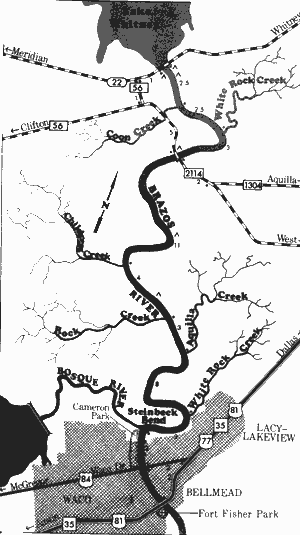
Brazos River
Whitney Dam to Waco Drive Bridge
39 Miles
Whitney Dam to Waco Drive Bridge
39 miles
This 39-mile section of the Brazos River in Bosque, Hill, and McLennan Counties is scenic, with tree-lined banks periodically giving way to bluffs of sheer limestone. Spring located on this section create excellent water quality. The water temperature is very cold in the upper portion since it comes from the bottom of Lake Whitney.
The river is wide with many deep holes of water. Unless Whitney Dam is generating, several shallow areas will be encountered on this section. A few small rapids are found, but there are no potentially hazardous places. Several private camps on this section, along with Corps of Engineers parks and a State Park on Lake Whitney, provide areas for camping and day use. Waterway features and distance between each are as follows:
Private camps - Three private camps are located off SH 22, just
below Lake Whitney Dam. Camping facilities are available.
Coon Creek - enters on the right. (2.5 miles)
White Rock Creek - enters on the left. (2.5 miles)
Private camp - off FM 2114, 5 miles south of Whitney Dam. (3 miles)
FM 2114 crossing - 5 miles south of Whitney
Dam. (0.1 mile)
Private camp - off FM 2114, 10 miles south
of Whitney Dam. (6 miles)
Childress Creek - enters on the right.
(5 miles)
Private camp - 11 miles northwest of Waco.
Camping facilities are available. (3 miles)
Rock Creek - enters on the right. (1 mile)
Aquilla Creek - enters on the left. (3 miles)
White Rock Creek - enters on the left.
(8 miles)
Bosque River - enters on the right. From
just above where the Bosque enters
the Brazos, deep water is formed by
Lake Brazos. (3 miles)
Cameron Park - a large city park located
on the right bank provides fair to poor
access. Picnicking facilities are
available. (0.1 mile)
Waco Drive Bridge - US 84 crossing in
Waco. About 100 feet of shoreline are
available. (2 miles)
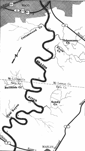
Brazos River
Waco to State Highway 7
38.7 Miles
Waco to State Highway 7
38.7 miles
Located in McLennan and Falls Counties, this 38.7-mile section of the Brazos River begins its slow meandering trek to the Gulf, flowing through rolling hills and flat coastal terrain. An occasional high bluff is found although limestone outcroppings such as those present on the upper reaches are not present. The water is no longer clear, but is often a murky color; however, its quality is sufficient for water contact sports. The Brazos River is scenic and contains heavily vegetated banks. There is sufficient water for recreational use at all times although during periods of dry weather shallow areas are found. One dam, forming Lake Brazos in Waco, exists. Water releases are automatic, and when the lake goes above conservation pool, the spillway is opened to release water. There are no road crossings other than the highway crossings in Waco and State Highway 7 near Marlin; therefore, the river is isolated. Waterway features and distance between each are as follows:
US 184 crossing (Waco Drive) - in Waco. About 100 feet of
shoreline are available.
Suspension Bridge - located about 200 yards below Waco Drive Bridge.
At one time this was the only suspension bridge that existed west
of the Mississippi River. The famous Brooklyn Bridge in New York City
was modeled after this bridge. (0.1 mile)
IH 35 crossing - in Waco. (0.5 mile)
Fort Fisher Park - adjacent to IH 35 crossing
in Waco. Restored Fort Fisher, or Homer
Garrison Memorial Museum, once the
headquarters of the Texas Rangers, is the
focal point of the park. Camping facilities
are provided by the city of Waco.
(0.1 mile)
SH 6, US 77, and US 81 crossing - in Waco.
(1 mile)
Brazos River Lake Dam - a portage is required.
(0.5 mile)
Cottonwood Creek - enters on the right.
(2.5 miles)
Tehuacana Creek - enters on the left.
(2.5 miles)
Shaw Creek - enters on the left. (4 miles)
Bullhide Creek - enters on the right.
(12 miles)
Sandy Creek - enters on the left. (2.5 miles)
Cow Bayou - enters on the right. (8 miles)
SH 7 crossing - 5 miles west of Marlin. A
Texas Parks & Wildlife Department boat
ramp is provided. (5 miles)
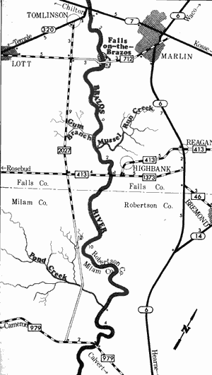
Brazos River
State Highway 7 to Farm-to-Market 979
28 Miles
State Highway 7 to Farm-to-Market 979
28 miles
Located in Falls, Milam, and Robertson Counties, this 28-mile section of the Brazos River is a scenic section suitable for recreational use at any time. The river is very wide and low water levels often create shallow areas. The scenery is similar to the previous section, containing high earthen banks and much vegetation. The river is sluggish and slow-moving with no existing rapids. However, there is one area which could prove hazardous to recreational use. This area, known as Falls-on-the-Brazos, contains a small waterfall which stretches across the river. A concrete low water crossing is also found at this site. If the water level is fairly high, the fall are navigable. A county park has been constructed adjacent to the falls. The remainder of the section presents no problems. Waterway features and distance between each are as follows:
SH 7 crossing - 5 miles west of Marlin. A
Texas Parks & Wildlife boat ramp is
provided.
Falls-on-the-Brazos crossing - a low water
crossing, off FM 712, 3 miles southwest
of Marlin. (3 miles)
Falls-on-the-Brazos County Park - located
adjacent to the low water crossing.
Camping facilities are provided.
(0.1 mile)
Mussel Run Creek - enters on the left.
(9 miles)
FM 413 crossing - 1 mile southwest of
Highbank. (2 miles)
Pond Creek - enters on the right.
(10 miles)
FM 979 crossing - 5 miles west of Calvert
and 15 miles northeast of Cameron.
(4 mile)
Farm-to-Market 979 to Gulf of Mexico
(Not mapped)
315 miles
The Brazos River throughout the lower sections is a very scenic coastal river. Here, the stream slowly meanders to the Gulf between wide, steep banks. The banks are lined with hardwood trees and many scenic bluffs and sand bars exist. Water levels for recreational use are sufficient year round. Strong southerly winds can create problems for boaters at times. One considerable rapid is located approximately 4 miles above US 90 between Washington and Brazos Counties. Known as Hidalgo Falls, this rapid is about one-fourth mile in length and large standing waves exist.
Top of Page | Table of Contents