- Table of Contents
- Foreword
- Introduction
- Texas Waterway Map
- Map Key
- East Texas Waterways
- Central Texas Waterways
- Major Waterways:
- Blanco River
- Bosque River
- Brazos River
- Colorado River
- Concho River
- Frio River
- Guadalupe River
- Lampasas River
- Lavaca River
- Leon River
- Little River
- Llano River
- Medina River
- Navidad River
- Nueces River
- Paluxy River
- Pedernales River
- San Antonio River
- San Bernard River
- San Gabriel River
- San Marcos River
- San Saba River
- Wichita River
- Seasonal and Restrictive Waterways
- Major Waterways:
- West Texas Waterways
An Analysis of Texas Waterways
A Report on the Physical Characteristics of Rivers, Streams, and Bayous in Texas
Major Waterways of Central Texas
Colorado River
The Colorado River has its beginning in Dawson County in West Texas. Flowing about 600 miles southeast to Matagorda Bay on the Gulf, the Colorado passes through a rolling prairie terrain until it reaches the rugged Hill Country in San Saba County. Here, the river flows through beautiful canyons until it issues from the Balcones Escarpment of Austin. Below Austin, the Colorado becomes a slow meandering river. The Highland Lakes, located on the Colorado in the Hill Country region, represent a unique series of reservoirs: Inks Lake, Lake Marble Falls, Lake Austin, and Town Lake. The waterway sections immediately above this series of reservoirs and below Austin to the Gulf are suitable for recreational use.
Farm-to-Market 669 to Flat Rock
(Not mapped)
326 miles
The Colorado River along its upper reaches does not have a steady flow of water until the Concho River enters the riverbed in Concho County. From this point on, the Colorado has a somewhat shallow and variable flow until it reaches the backwaters of Lake Buchanan. Recreational use appears feasible along the entire stretch downstream from the Concho River. However, the best sections for recreational use are located below the junction of the San Saba River with the Colorado.
Two large reservoirs, Lake J. B. Thomas and E. V. Spence Reservoir, are located on the upstream portion of the Colorado River. It is possible to utilize, for recreational purposes, those areas where the reservoirs have created "slack water" or still water just above the reservoirs. Recreational use is also possible for a short distance below the dams when water is being released. However, the upper reaches of the Colorado River generally are infeasible for recreational use.
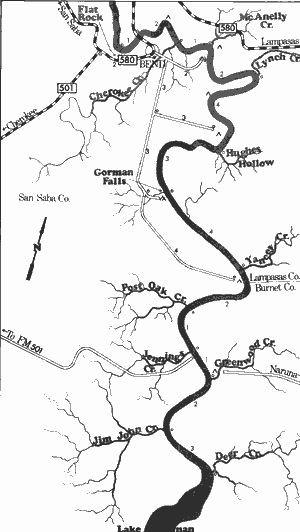
Colorado River
Flat Rock to Lake Buchanan
26 Miles
Flat Rock to Lake Buchanan
26 miles
This 26-mile section of the Colorado River in San Saba, Llano, Lampasas, and Burnet Counties is very unique and scenic. Among its scenic attributes are high limestone bluffs, vistas of rugged cedar-covered hills, and the existence of one of the most spectacular waterfalls in Texas. Gorman Falls is formed at the point where Gorman Creek tumbles into the Colorado over a 75 foot tall limestone bluff. The water coming from the creek is clear and cold, and many ferns and mosses grow on the slippery rocks and travertine deposits below the falls.
The river itself is wide and relatively shallow, flowing over a bed of limestone and gravel. Extensive irrigation upstream depletes the water supply during dry months. However, periods of sufficient rainfall provide excellent opportunities for recreational activities. A few small rapids exist on the upper part of this section down to the point where the backwaters of Lake Buchanan deepen the river and slow its flow.
The river area is moderately accessible because of the existence of several private fishing camps. There is only one road crossing along the entire 26-mile stretch; therefore, portions of this section are fairly isolated. Waterway features and distance between each are as follows:
26 Miles Flat Rock - 1 mile west of Bend on RR 580.
A large limestone slab called "flat rock"
extends from the highway to the river.
RR 580 crossing - one-half mile northwest
of Lometa. Access is very poor. (1 mile)
Private camp - 12 miles southwest of Lometa
off RR 580. About 1 mile of shoreline is
available for access, but no facilities are
provided.
Cherokee Creek - enters on the right.
(2 miles)
McAnelly Creek - enters on the left. (1 mile)
Private camp - east of Bend on a dirt road
off RR 580 in San Saba County. About
3 miles of shoreline are available and
picnicking facilities are provided.
Private camp - 20 miles west of Lampasas
off RR 580 in Lampasas County.
Approximately 1 mile of shoreline
provides access, but no facilities are
available.
Lynch Creek - enters on the left. (2 miles)
Private camp - southeast of Bend on a
dirt road. Access is available, and
picnicking facilities are provided.
Private camp - southeast of Bend on a
dirt road. About 3 miles of shoreline
provide access, and camping facilities
are available.
Hughes Hollow - enters on the left. (4 miles)
Private camp - south of Bend on a dirt road,
located at Gorman Falls. About 1 mile
of shoreline provides access, and
camping facilities are available. (3 miles)
Yancy Creek - enters on the left. (4 miles)
Private camp - southeast of Bend on a dirt
road. Camping facilities are available.
Post Oak Creek - enters on the right.
(2 miles)
Jennings Creek - enters on the right.
(1 mile)
Private camp - 6 miles northwest of Naruna
on a county road in Burnet County.
Approximately 2 miles of shoreline
are available, but no facilities are
provided.
Greenwood Creek - enters on the left.
(1 mile)
Jim John Creek - enters on the right.
(2 miles)
Deer Creek - enters on the left. (3 miles)
Lake Buchanan is located immediately
below Deer Creek. Numerous access
points are available around the lake.
Colorado River
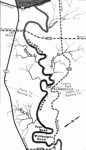
US Highway 183 to Farm-to-Market 969
36 Miles
US Highway 183 to Farm-to-Market 969
36 miles
Located immediately below Austin in Travis and Bastrop Counties, this 36-mile section of the Colorado River contains a water flow controlled exclusively by the entire series of Highland Lakes located upstream. However, there is usually a sufficient flow of water in the river for recreational use since Longhorn Dam at Town Lake maintains a fairly continuous release. The river is extremely wide and slow-moving with no rapids or hazardous places, only slow-moving water with a few ripples and areas of swift water.
Vegetation along the banks consist of elm, willow, and sycamore; while the riverbed contains various aquatic plants which provide cover for many fishes. The flood plain is flat, and limestone outcroppings are not as abundant as they are above the Highland Lakes. Several earthen cut-banks are exposed throughout this section. The river bottom is composed of sand and gravel, with sand and gravel bars and islands providing suitable areas for camping.
Although there are only three road crossings on this section, the river has good access due to the existence of a county park between FM 973 and FM 969, near the Travis-Bastrop county line. Travis County has undertaken a project to provide better access and establish camping areas along this section of the Colorado River. Waterway features and distance between each are as follows:
US 183 crossing (Montopolis Bridge) - in
East Austin. A road leads down to a
gently sloping bank where access is very
good.
Walnut Creek - enters on the left. (5 miles)
FM 973 crossing - 1 mile northeast of Del Valle.
(4 miles)
Onion Creek - enters on the right. This beautiful
creek has potential for recreational use.
(5 miles)
Decker Creek - enters on the left. (4 miles)
County park - 10 miles east of Austin off
FM 969 in the community of Webberville.
A boat ramp provides good access, and
picnic tables are available. (2 miles)
Dry Creek - enters on the right. (6 miles)
FM 969 crossing - 5 miles northwest of
Bastrop. An existing Texas Parks &
Wildlife boat ramp provides good
access. (9 miles)
Colorado River
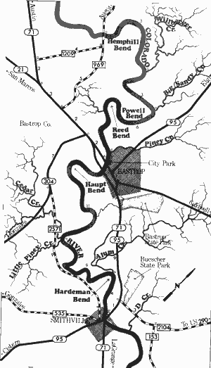
Farm-to-Market 969 to State Highway 71
38 Miles
Farm-to-Market 969 to State Highway 71
38 miles
This 38-mile section of the Colorado River is located entirely within Bastrop County. The river between FM 969 and Bastrop is similar to the section immediately upstream. That is, vegetative types are basically the same, consisting of elm, willow, sycamore, and various aquatic plants which are found in the riverbed. However, the Lost Pines, a section of pines that have become isolated from the East Texas piney woods, are found along the river in several places between Bastrop and Smithville. Sand and gravel compose the river bottom and sand and gravel bars appear frequently. The river, along this section, is extremely wide, and water flow is consistent, but slow. There exist no difficult rapids of hazardous places on this entire section, although a few minor rapids are found. The banks of the Colorado gradually steepen as the river moves downstream. The flood plain deepens and the steep banks become extremely scenic with high sandstone bluffs and cliffs, along with several islands and sand bars which are often utilized for camping and day use. The lower Colorado River Authority has initiated a project to provide improved access points and suitable camping areas for recreationists on the section between Bastrop and Smithville. Waterway features and distance between each are as follows:
FM 969 crossing - 5 miles northwest of
Bastrop. An existing Texas Parks &
Wildlife boat ramp provides good access.
Wilbarger Creek - enters on the left. (3 miles)
Big Sandy Creek - enters on the left.
(3 miles)
Piney Creek - enters on the left. (6 miles)
City park - located in Bastrop. An existing
boat ramp provides access, and picnic
tables are available. (1 mile)
SH 21 crossing - in Bastrop. No access is
available. (0.5 mile)
SH 71 & 95 crossing - in Bastrop. No
access is available. (0.5 mile)
Cedar Creek - enters on the right.
(11 miles)
Little Piney Creek - enters on the right.
(0.5 mile)
Alum Creek - enters on the left. (9 miles)
SH 71 crossing - in Smithville. An existing
Texas Parks & Wildlife boat ramp
provides good access. (4 miles)
Colorado River
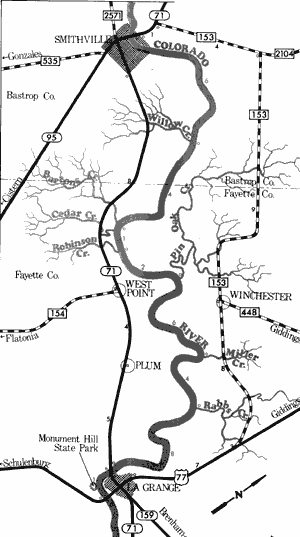
State Highway 71 to US Highway 77
32 Miles
State Highway 71 to US Highway 77
32 miles
This 32-mile section of the Colorado River in Bastrop and Fayette Counties contains a number of unique points of interest. Several large cliffs exist along this section, and many springs lined with ferns issue from these formations. The presence of petrified logs in some of the limestone cliffs has been reported and fossils have been discovered in some of the cut banks along the river. The river itself is a slow, meandering stream that is quite scenic with heavy vegetation lining the banks. Numerous sand bars are available which often lend themselves to camping and day use. There are a few areas containing swift water and minor rapids, but no hazardous places exist. Waterway features and distance between each are as follows:
SH 71 crossing - in Smithville. An existing
Texas Parks & Wildlife boat ramp
provides good access.
Willow Creek - enters on the right.
(6 miles)
Bartons Creek - enters on the right.
(4 miles)
Cedar Creek - enters on the right. (0.3 mile)
Robinson Creek - enters on the right.
(0.7 mile)
Pin Oak Creek - enters on the left. (2 miles)
Miller Creek - enters on the left. (6 miles)
Rabbs Creek - enters on the left. (4 miles)
SH 71 crossing - located on the southwest
edge of La Grange. Adequate access
is available. (8 miles)
US 77 crossing - located south of La
Grange. Poor access is available.
(1 mile)
Monument Hill State Park is located
between SH 71 & SH 77, near La Grange.
Picnicking facilities only are available.
US Highway 77 to Matagorda Bay
(Not mapped)
186 miles
The section of the Colorado River from La Grange to the Gulf of Mexico is a slow-moving, scenic coastal river. The river is wide, deep, and plenty of water for recreational use is available at all times. There are no hazards but occasional strong headwinds from the south often hinder recreational use of this stretch. Numerous hardwood trees line steep banks and large sand bars, which often lend themselves to camping and day use, are found.
Top of Page | Table of Contents