- Table of Contents
- Foreword
- Introduction
- Texas Waterway Map
- Map Key
- East Texas Waterways
- Central Texas Waterways
- Major Waterways:
- Blanco River
- Bosque River
- Brazos River
- Colorado River
- Concho River
- Frio River
- Guadalupe River
- Lampasas River
- Lavaca River
- Leon River
- Little River
- Llano River
- Medina River
- Navidad River
- Nueces River
- Paluxy River
- Pedernales River
- San Antonio River
- San Bernard River
- San Gabriel River
- San Marcos River
- San Saba River
- Wichita River
- Seasonal and Restrictive Waterways
- Major Waterways:
- West Texas Waterways
An Analysis of Texas Waterways
A Report on the Physical Characteristics of Rivers, Streams, and Bayous in Texas
Major Waterways of Central Texas
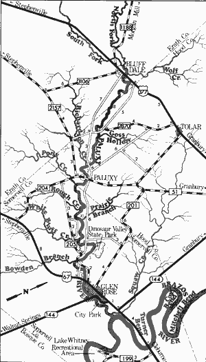
Paluxy River
Rising in northeast Erath County, the Paluxy River flows southeast for 38 miles through Wood and Somervell Counties to join the Brazos River. The river is formed by the junction of the North and South Forks, both of which are small streams that contain insufficient water flows for normal recreational use. In addition, the main stream is feasible for recreational use only during periods of heavy rains. The Paluxy is a scenic waterway containing clean, clear water flowing over sand and rocks, and surrounded by cedar-covered hills and limestone bluffs.
Paluxy River
Bluff Dale to Glen Rose City Park
34 Miles
Bluff Dale to Glen Rose City Park
34 miles
During periods of sufficient water in the streambed, this 34-mile section of the Paluxy river has potential for recreational use. The stretch between Paluxy and Glen Rose contains the famous Dinosaur Valley where well-exposed dinosaur tracks have been found in the riverbed (Dinosaur Valley State Park is located within this area). The river at the Park is a small, narrow waterway and occasionally has sufficient water for recreational use. During periods of heavy rainfall, the river reportedly contains numerous rapids. Scenic hardwood bottomlands consisting of oak, elm, and cedar are common along the entire section. Many outcroppings of limestone exist, and in some places, the riverbed itself is composed entirely of limestone. Many sand bars are present which, when combined with the State Park, insure ample areas for camping and day use. Access however, remains somewhat of a problem since some of the road crossings are fenced. In general, the Paluxy is a picturesque river providing excellent recreational conditions when sufficient water levels are present. Waterway features and distance between each are as follows:
US 377 crossing - located in the small town of Bluff Dale.
County road crossing - off FM 2870 when extended, 6 miles south of Tolar. (8 miles)
Goss Hollow - enters on the left.
County road crossing - off FM 204, 8 miles southeast of Tolar
and 1 mile northwest of the town of Paluxy. (4 miles)
Richardson Creek - enters on the right.
FM 204 crossing - in the town of Paluxy, 13 miles southwest
of Granbury. Access to the river is fenced off. (2 miles)
Pony Creek - enters on the right.
Rough Creek - enters on the right.
Prairie Branch - enters on the left.
White Bluff Creek - enters on the right.
County road crossing - off FM 205, 4 miles
west of Glen Rose. (10 miles)
Dinosaur Valley State Park - 3 miles northwest of Glen Rose. Camping facilities
are available. (1 mile)
FM 205 crossing - 2 miles west of Glen
Rose. (3 miles)
Bowden Branch - enters on the right.
County road crossing - between US 67
and FM 205, 1 mile west of Glen
Rose. (1 mile)
US 67 crossing - located at the western
edge of Glen Rose. Access to the river
is fenced off. (2 miles)
SH 144 crossing - in Glen Rose. (3 miles)
Glen Rose City Park - located immediately
downstream from SH 144. (0.1 mile) Approximately 2 miles downstream,
the Paluxy river becomes a tributary
of the Brazos River.
Pedernales River
Totaling approximately 106 miles in length, the Pedernales River rises in Kimble County and flows southeast through Gillespie, Blanco, Hays, and Travis Counties where it meets the Colorado River. The backwaters of Lake Travis are formed on the last few miles of the Pedernales. The river is spring-fed, free-flowing, and has many outstanding scenic qualities. The upper Pedernales at normal water levels has an insufficient flow for recreational use. However, the lower section contains the greatest volume of water at normal levels, and contains suitable conditions for recreational use.
Harper to US Highway 281
(Not mapped)
66 miles
The Pedernales River is a scenic Hill Country stream, flowing through rocky, rugged country. Water levels are usually insufficient for normal recreational use of the upper reaches during most of the year. However, during periods of runoff, portions of the upper Pedernales have the potential to become an exciting white water recreational waterway. However, these high water conditions can be very dangerous to inexperienced waterway recreationists. The river above US 281 is extremely narrow and shallow, while the stretch below US 281 is feasible for recreational use if the river is on a slight rise. Waterway features are as follows:
Country road crossing off FM 2093 - 6 miles southeast of Harper.
County road crossing off FM 2093 - 17 miles west of Fredericksburg.
County road crossing off FM 2093 - 16 miles west of Fredericksburg.
County road crossing off FM 2093 - 11 miles west of Fredericksburg.
County road crossing between FM 203 and SH 16 - 9 miles south of Fredericksburg.
SH 16 crossing - 7 miles southwest of Fredericksburg.
County road crossing off US 16 - 5 miles southeast of Fredericksburg.
County road crossing off US 16 - 4 miles southeast of Fredericksburg.
County road crossing off US 16 - 3 miles southwest of Fredericksburg.
US 87 crossing - 3 miles south of Fredericksburg.
County road crossing off US 290 - 3 miles south of Fredericksburg.
County road crossing off US 290 - 4 miles southeast of Fredericksburg.
County road crossing off US 290 - 7 miles southeast of Fredericksburg.
County road crossing off US 290 - 10 miles southwest of Fredericksburg.
County road crossing off US 290 - 11 miles west of Fredericksburg.
County road crossing off US 290 - 12 miles west of Fredericksburg.
County road crossing off US 290 - 14 miles west of Fredericksburg.
FM 1320 crossing - 8 miles west of Johnson City.
US 281 crossing - one mile northeast of Johnson City.
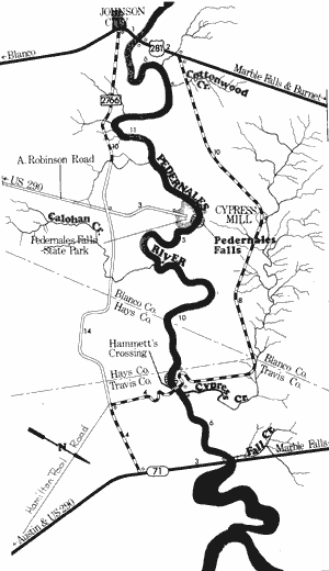
Pedernales River
US Highway 281 to State Highway 71
39 Miles
US Highway 281 to State Highway 71
39 miles
This 39-mile section of the Pedernales River in Blanco, Hays, and Travis Counties is an isolated section of waterway flowing through the rugged Hill Country. There are only three road crossings on the entire section, and the Pedernales Falls State Park provides the only other public access point. The river varies in width from 30 to 60 feet and remains relatively shallow for the entire distance. At normal water levels, a minimum amount of water for recreational activities is available. The best water level exists when the river is on a 1 to 2 foot rise. Several exciting rapids are found during these periods, with one excellent rapid being located immediately upstream from Hammett's Crossing. Pedernales Falls, located at the State Park always is a potential hazard to navigation. Because of the difficulty in portaging the Falls, recreational usage from Pedernales Falls State Park to Hammett's Crossing appears most feasible. Also, better water conditions are more common along this stretch. The river is a typical Hill Country river and is well known for its outstanding scenic qualities. Large limestone outcroppings, cedar-covered hills and bluffs, and stately bald cypress trees are present along with abundant wildlife.
Here, the river generally has a wide flood plain and the land opens out for a distance before the hill and bluffs begin. Several sand and gravel bars, in addition to the State Park, are often available for camping and day use. In general, this section of the Pedernales combines outstanding scenic qualities and some exciting rapids (when the river is on a slight rise) to create a quality recreational waterway. Waterway features and distance between each are as follows:
US 281 crossing - 1 mile northeast of
Johnson City. About 100 feet of shoreline
are available on the highway right-of-way.
Cottonwood Creek - enters on the left.
(6 miles)
Pedernales Falls State Park - located at the
end of A. Robinson Road, 12 miles northeast of Johnson City. Facilities for
camping and picnicking are available.
Access to the river is limited, and a
portage of about 150 to 200 yards down
a steep hill is required. (11 miles)
Calohan Creek - enters on the right.
(5 miles)
Hammett's Crossing - County road
crossing, off SH 71, 25 miles west
of Austin. Access is poor at this low
water crossing. (10 miles)
Cypress Creek - enters on the left. This is
a small but beautiful creek that
contains crystal clear waters. (1 mile)
Fall Creek - enters on the left. (6 miles)
SH 71 crossing - 20 miles west of Austin.
The high bridge provides poor
access. (0.1 mile)
Private camp - located just below SH 71.
Immediately downstream from SH 71
is Lake Travis.
San Antonio River
The San Antonio River has its beginning in large springs within the corporate limits of San Antonio. The river flows approximately 180 miles across the Coastal Plains to junction with the Guadalupe River near San Antonio Bay. The San Antonio River's principal tributaries are the Medina River and Cibolo Creek, both spring-fed streams. This, plus the San Antonio's own origin in springs, insure that the river has a relatively constant flow of water. The San Antonio River us primarily a coastal river that flows slowly and deliberately to the Gulf. The banks are generally steep and muddy with many log jams prevalent that might prove hazardous to recreational navigation.
Downtown San Antonio to Floresville
(Not mapped)
48 miles
The upper reaches of the San Antonio River are suitable for recreational use at any time because of the many large springs within San Antonio. The river has developed into a scenic parkway in San Antonio. General recreational use of the river and parkway is restricted by the city of San Antonio. However, paddle boats may be rented along the river walk. Below San Antonio, the river is available for general recreational use with numerous road crossings which provide access to most sections of the river.
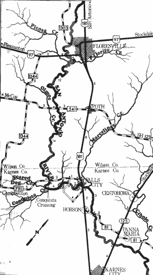
San Antonio River
Floresville to Hobson
36 Miles
Floresville to Hobson
36 miles
This 36-mile section of the San Antonio River is located in Wilson and Karnes Counties. The river is approximately 50 to 75 feet wide and meanders slowly between steep, earthen banks. Because of the number of springs which feed the river, it always contains sufficient water for recreational use. No large rapids are found and navigation is normally made on slow-moving water. Two waterfalls exist on this section. The banks of the waterway are scenic, containing vegetation consisting of elm, willow, cottonwood, and sycamore. The main hazards present are occasional log jams, some of which require a portage. Waterway features and distance between each are as follows:
US 97 crossing - 1 mile southwest of
Floresville.
FM 541 crossing - 6 miles south of
Floresville. (12 miles)
FM 791 crossing (Conquista Crossing) -
3 miles southwest of Falls City.
(14 miles)
Skiles Falls - a waterfall has been found
approximately three miles downstream
from FM 791, near Falls City. (3 miles)
County road crossing - 1 mile southwest of
Falls City. (1 mile)
Waterfall - a waterfall is located approximately one mile upstream from US 181,
near Falls City. (1.5 miles)
US 181 crossing - located on the southeastern city limit of Falls City. (1 mile)
FM 81 crossing - 1 mile east of Hobson.
(3 miles)
Hobson to the Guadalupe River Junction
(Not mapped)
152 miles
Throughout the lower sections, the San Antonio River remains a slow, sluggish, and meandering coastal river. Water levels are adequate for recreational use, but the water quality deteriorates considerably. However, water quality is considered by the Texas Water Quality Board, as above the minimum level for water contact sports, despite its somewhat murky appearance. The river becomes more isolated on the lower sections, since road crossings become fewer and farther between. Occasional log jams are the only major obstacles. Goliad State Park is located adjacent to the river.
San Bernard River
Rising in northwestern Austin County, the San Bernard River flows southeast, forming the boundary between Austin and Colorado Counties, then into Wharton and Fort Bend Counties where it flows into the Gulf of Mexico. Its total length is 125 miles. The San Bernard is a coastal river, located entirely within the coastal plains. The river does not contain a large volume of water, but lower sections have sufficient water for recreational use at any time. The river flows slowly into the Gulf of Mexico with no potential hazards existing along its entire length.
Cat Spring to Farm-to-Market 1093
(Not mapped)
24 miles
The upper reaches of the San Bernard River, from its source to FM 1093, is a narrow, winding coastal waterway which, at normal water levels, is often suitable for recreational use (flow in minimal). Several springs have been located along this section and the river is lined with numerous hardwood trees. Log and brush jams are present, and the main channel is difficult to locate during periods of extremely high water. However, this section is scenic, and recreational use is possible provided adequate water levels exist.
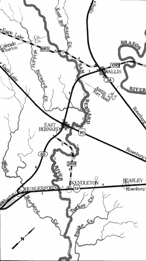
San Bernard River
Farm-to-Market 1093 to US Highway 59
27 Miles
Farm-to-Market 1093 to US Highway 59
27 miles
This 27-mile section of the San Bernard River is located in Austin, Wharton, and Fort Bend Counties. The river has its beginnings within the Coastal Plains, yet unlike other coastal river, it contains many springs. This particular stretch contains several of these springs, which insures that this section normally has minimum flow for recreational use. The river is lined with vegetation consisting of oak, elm, willow, pecan, and other hardwoods. Water quality is good, and a sufficient volume of water for recreational use is always maintained. No hazards exist. In general the San Bernard River contains points of interest which are unique to the coastal rivers of Texas. Waterway features and distance between each are as follows:
FM 1093 crossing - 8 miles northwest of
East Bernard.
East Bernard Creek - enters on the left.
(1 mile)
SH 60 crossing - 4 miles north of East
Bernard. (3 miles)
Middle Bernard Creek - enters on the right.
(5 miles)
US 90A crossing - eastern city limit of East
Bernard. The river is narrow, and the
main channel is difficult to distinguish.
(3 miles)
FM 2919 crossing - between SH 60 in
Wharton County and US 59 in Fort Bend
County, 2 miles southeast of East
Bernard. (6 miles)
US 59 crossing - 8 miles northeast of
Wharton at Kendleton. (9 miles)
Top of Page | Table of Contents