

Fall 2011 A publication of the Wildlife Division—Getting Texans Involved
 Understanding Creeks and Rivers
By Steve Nelle
Although most outdoor type people will proclaim their love and appreciation of creeks and rivers, most would admit they don't know a great deal about how these special parts of the landscape work. African ecologist, Baba Dioum penned an oft quoted truth:
"We will conserve only what we love;
We will love only what we understand;
We will understand only what we are taught."
Without a genuine knowledge about the workings of nature it is questionable whether we can ever truly love or conserve natural resources.
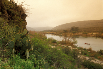
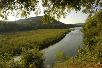
In Texas, our knowledge and concern about the workings of creeks and rivers and riparian areas is fairly recent. In fact, the term "riparian" is relatively new if not unknown to many people. The riparian area is the narrow band of land that lies immediately adjacent to creeks, rivers, ponds and lakes. It is the transition area between the dry uplands and the water itself. The term "creek bottom" is a more familiar term that is somewhat analogous to the riparian area. Riparian areas have unique water, soil and vegetation attributes that make them much different than adjacent upland areas. Although the riparian area only comprises one to five percent of the total landscape, its contributions and value are much greater than its relatively small size.
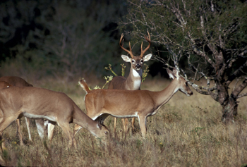
The values and benefits of a healthy riparian area are many and varied. Birders often find the greatest variety and abundance of bird life in the riparian zone where they find travel corridors, diverse cover, food and water. Turkey enthusiasts understand the critical importance of riparian roost areas; wood duck hunters appreciate the riparian woodlands that provide nest cavities and food. Fishermen appreciate the value of stable channels, deep pools, undercut banks, submerged logs, shade, water quality and other riparian/aquatic habitat features. Livestock ranchers place great value on the abundance of high quality grazing that often exists in the riparian area. Campers, canoeists, hikers, and just about everyone seems to especially enjoy the richness and beauty of an intact creek/riparian area.
Yet, even though we appreciate and value creeks, rivers and the associated riparian area, we seldom think about the inner workings that support these values. When the creek/riparian area is functioning properly, all of the natural processes will be in balance, which in turn, will insure that the values we desire will be produced and maintained.
The astute naturalist, hunter, or landowner understands that nature is always more complex than it appears on the surface. Discovering the intricacies of the natural world is not only enjoyable and challenging, but is essential in providing the basis for the proper management and stewardship of the land.
To fully understand the complexities of the riparian landscape would require specialized knowledge about hydrology, vegetation and the physics behind the erosion and deposition of soil by moving water. Few people possess this depth of knowledge, but a basic understanding is not difficult to grasp.
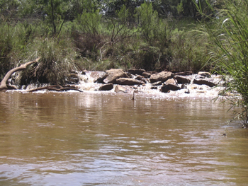
To properly understand creeks and rivers, one must first appreciate the value of flooding and the necessity of a floodplain. Flooding is not something bad that happens to creeks and rivers; it is an essential part of the creek and river system. Without frequent and recurring floods, a creek is simply a drainage ditch or a canal. In fact, periodic flooding is what ultimately provides many of the values and benefits that we desire. Out-of-bank flooding, where the water fills the channel and spills out on to the active floodplain should typically occur about every one to three years. This is the kind of flooding that maintains the ecological integrity of the creek.
There is a great deal of common sense physics involved in a properly functioning riparian area. First and foremost, in a healthy riparian area, there will be dense riparian vegetation growing on the banks and floodplains. These plants have phenomenally strong and extensive root systems. The root systems of riparian plants usually have five to ten times more root density and root mass compared to upland plants. For example sideoats grama, an upland grass, has about 4,000 pounds of roots per acre; while knotgrass, a riparian grass, has about 24,000 pounds of roots per acre. Furthermore, knotgrass has been shown to have an astounding 19 miles of roots per cubic foot of soil. This extreme network of intermeshing roots helps to bind riparian soils together during flooding to minimize bank and channel erosion. In some parts of Texas this critical rooting is provided primarily by riparian trees and shrubs while in other areas it is provided mostly by grasses, and sedges.
In addition to the extensive root systems, dense riparian vegetation also helps dissipate the energy of floodwaters. As the energy of water is interrupted by a thick growth of shrubs, trees, grasses and sedges, the velocity of water is reduced, which in turn reduces the erosive potential along the banks. As the velocity of floodwater is reduced, the ability of water to carry sediment is also reduced, which allows some of the sediment to settle out on the floodplain. This sediment (mud, silt, sand, gravel) that is deposited during flood events, becomes assimilated into the banks and floodplain by the new growth of riparian plants. Each new unit of sediment that becomes trapped in the riparian area provides additional water storage capacity. This is sometimes referred to as the "riparian sponge". Due to the pore space contained within soil, a cubic foot of soil has the capacity to store two to four gallons of water. The more sediment that is captured and stabilized by riparian vegetation the more water can be stored along the banks. This riparian sponge gets refilled each time floodwater spills out of the channel. After the riparian sponge is filled, it helps sustain plant growth and excess water slowly seeps back into the channel to help maintain normal base flow. This concept of storing water in the banks and floodplains is an important contribution of a functional riparian area.
Besides the water that is stored in riparian soils and captured sediments, flooding also provides for the recharging of shallow aquifers that are associated with creeks and rivers. As the water is slowed down by the vegetation, and as the waters spread out across the floodplain, these shallow water tables absorb and store immense volumes of water. Then, after the floodwaters recede back into the channel, the newly refilled water table is what sustains the flow of creeks between runoff events.
When these necessary physical processes are occurring and in working balance, then, the desired values that we appreciate are provided and sustained. If you want good water quality, sustained base flow, good fish habitat, good wildlife habitat, good livestock forage, make sure that these physical processes are happening: dense vegetation dissipating energy; roots providing bank and channel stability; trapping of sediment in the floodplain; storage of water in banks and floodplain.
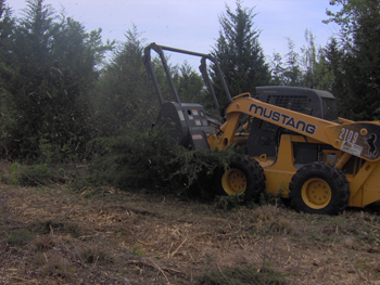
For riparian areas that are not functioning properly, there is good news - riparian areas have the amazing capacity to restore themselves naturally. In most cases, man does not have to fix damaged creeks or rivers with extensive or expensive solutions. Usually, all that man needs to do is to address those things that may be hindering this natural recovery. Dense, healthy riparian vegetation is the key to maintaining or restoring good riparian condition.
The benefits and values of functional riparian areas are important to all Texans, not just landowners, fishermen and birders. The next time you take a walk in a creek bottom begin to notice some of the attributes that support a functional riparian area; it will help you develop a deeper appreciation and understanding of this remarkable part of nature.
Steve is a wildlife biologist with the Natural Resource Conservation Service working out of San Angelo, TX.
Otter Map Project
By Gary Calkins
Three years ago, the tri-annual schedule showed it was time to run river otter bridge surveys in east Texas. This survey covers 27 counties across the Pineywoods ecoregion of the State. For the most part, this area is also considered the primary species range of the river otter which is why the emphasis on the surveys in this part of Texas. While that survey effort was being undertaken, three additional otter related projects were also happening. Ciel Wharton was completing a MS project at Texas A&M University dealing with measuring observers skills in identifying the sign used for the otter surveys. Jonah Evans was completing his MS Project, also at A&M, on how mis-identification of sign could bias these surveys. Also occurring, I was just starting my MS project at Stephen F. Austin on how to improve the survey technique itself.
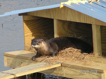
With all of this activity on otters at once, the species started getting some renewed attention. One of the first that wanted some more information was Cecilia Nasti with the Passport to Texas Radio program. Cecilia wanted to do a Passport to Texas segment on otters and find out what all the fuss was about; I think that segment actually started the fuss. Shortly after that segment aired, Cecilia started receiving emails from several locales indicating that they had seen otters. As she received those messages, Cecilia would forward them to me and I began plotting the locations on a map; initially just for fun to see where folks were seeing these animals. The sightings continued to roll in and it was obvious that folks out there were interested in this critter based on the response to that one segment.
A year later Cecilia decided to run a follow-up Passport to Texas segment and ask for sightings to be sent in to be placed on the map. At the same time, Tom Harvey with the Parks and Wildlife Communications team also released a press release along the same lines. Wow; the response was immediate. Not only were we getting responses from the public, but several other outdoor writers ran stories on otters and then the responses really started rolling in. It has been an interesting task to read all of the sighting information sent in, try to verify the location, read the stories and see some fantastic photographs that folks have taken of otters and sent in. As the reports kept coming, the map database continued to grow; as it still does today.
I can't think of a week that has gone by since that second Passport to Texas segment ran that there hasn't been at least one email with an otter story to tell; often it is 2 or 3 a day. Each of the responses has a story to tell, most of which are excited or interested and some that fear that they will lose every fish in their pond, but each has something to share.
As folks shared those stories, I have also learned a lot; not only about where folks have seen otters, but how passionate folks are for our wildlife resources. Whether the concern was how many fish those critters were eating or sharing a great photograph the passion came through on nearly every communication. That is one thing that has really struck me about this whole process and a part of it I have sincerely enjoyed.
But now down to some of the interesting details; where those sightings have come from, and it is far and wide across the State. To date, I have been able to get enough information to plot the location of 203 different sightings on the map from these reports. In some instances I will receive several reports from a given lake such as Lake Conroe and in those instances I have combined all of the sightings into one record since there is no way to determine if folks saw many different animals or just one animal making the rounds. As the sightings started coming in, most were in places that otters were expected to be, but as the word spread about sending sightings in, so did the variety of places that the animals showed up. At first, when a sighting is received in a location that is unexpected, it is hard not to be a bit skeptical; which was the case in some of the first unusual sightings. But it didn't take too many pictures to convince me that skepticism has a place in some respects, but not in regards to this project.
As the map currently stands, 30 to 40 percent of the sightings are west of the I45 corridor and nearly 10 percent of the locations falling west of the I35 corridor. There are a dozen sightings right in the Austin area, one just north of San Antonio, and the interesting outlier about half way between Gainesville and Wichita Falls. The sightings in the eastern portion of the state are fairly evenly distributed across the landscape which leads one to the conclusion that there are otters in most of the larger waterways across this area.
Historically, otters were considered to be located in the eastern two-thirds of the state and up into portions of the Panhandle. Due to hunting and the fur market, by the 1960's they were considered to be restricted only to the Neches and Trinity River basins. If the dots on the map over the past two years are indicative of anything, otters are moving back into old familiar haunts and may be moving into a creek near you. Enjoy one of our truly unique native species!
Gary Calkins is the District Leader for wildlife in the Piney Woods area for Texas Parks and Wildlife Department. He offices out of Jasper.
Cooperative Conservation Partnership Initiative (CCPI) in Texas
By Gene T. Miller
Amanagement plan is currently being developed that will direct the future efforts of the Canadian River CWMA. National Wild Turkey Federation and its partners are moving forward with invasive species control projects as a first step toward riparian restoration. The main thrust is removal of salt cedar, eastern red cedar, and Russian olive to improve wildlife habitat and native plant communities along the river, especially as related to native cottonwood stands. In July 2009, NWTF signed a Cooperative Conservation Partnership Initiative (CCPI) Agreement in Texas with NRCS and Texas Parks and Wildlife Department that dedicates $500,000 per year in EQIP funding through 2013 to the CWMA in Texas.
A public meeting was held with Hutchinson County landowners in August 2009 and was well attended. Several landowners signed up for EQIP contracts by the September (2009) deadline and invasive plant control occurred during the summer of 2010 with additional contracts signed in Hutchinson and Hemphill Counties during 2010. In addition to EQIP funding, Texas Parks and Wildlife Department (TPWD) agreed to provide $50,000 per year of matching money through 2014, the Texas State NWTF Chapter dedicated $25,000 of Hunting Heritage Super Fund monies, and a 2010 PLJV ConocoPhillips Grant was secured for $25,000. The organizational and funding goals of the CWMA were met during the first two years of the project and work on the ground to restore riparian habitat is ongoing now during 2011, albeit at a slower pace than what all cooperating partners would like to see happen. To date, invasive plants have been controlled on 971 acres of riparian habitat on the Canadian River in Texas with this project.
In the summer of 2010, the CCPI Partnership secured a Memorandum of Agreement with the State of Texas - General Land Office which authorized removal of invasive plants on state lands within the gradient boundary along the Canadian River and its tributaries from Sanford Dam to the state line in Hutchinson, Roberts, and Hemphill Counties. This was a very positive development and key to the success of this project. Additional funds will be secured to treat large blocks of salt cedar along certain stretches on GLO lands (they have no funds for this work). The CCPI Partnership also gained the help and support of several local contractors for chemical Individual Plant Treatment (IPT) work.
Landowners who are contacted about the program are also offered information about TPWD's free, confidential, non-binding wildlife technical guidance services. As well, the Gene Howe Wildlife Management Area in Hemphill County serves as a demonstration site for riparian restoration, being the site of several NWTF Hunting Heritage Super Fund Projects from 2005 until the present time. National Wild Turkey Federation is very proud of its association with Texas Parks and Wildlife Department and the Texas State NWTF Chapter in this landscape effort aimed at eventually restoring up to 93,000 acres of prime wildlife habitat along the Canadian River in Hutchinson, Roberts, and Hemphill Counties.
New in 2011 is the addition of cost share funds to assist landowners downstream in Oklahoma with the same project (mostly Eastern red cedar control at this time). The South Canadian River Floodplain Management Area EQIP Local Emphasis Area (a mouthful) administered by USDA-NRCS offers $200,000 per year for invasive plant removal work to landowners in Ellis, Roger Mills, and Dewey Counties with additional cost share provided by mitigation funds via the Playa Lakes Joint Venture through High Plains Resource Conservation & Development Council in northwest Oklahoma; and, the money is put on the ground with individual landowners through NWTF Wildlife Management Agreements executed per NWTF Regional Biologist, as is done in Texas.
Again, partnerships thrive as part of this process due to financial and technical services offered to landowners by Oklahoma Department of Wildlife Conservation and Oklahoma Forestry Services for restoration of land and wildlife habitat. As has been said many times in conservation circles, challenges such as removal of invasive plant species from a major watershed like the Canadian River are bigger than all the participants, and National Wild Turkey Federation will continue to seek out partnerships for restoration of habitat, not just for wild turkeys, but for a wide variety of native species. "It's about the habitat!" said Miller.
Gene is the regional biologist with the National Wild Turkey Federation working out of Canyon, TX.
Mad Island WMA Shoreline Protection Project
By Jeff Raasch and Matt Nelson, TPWD
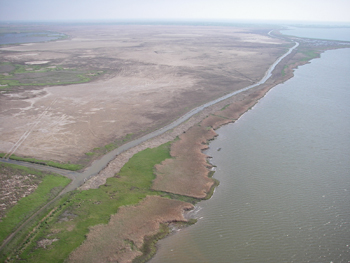
The wetlands are important nursery grounds for recreationally and commercially important aquatic species including shrimp, finfish, and crabs. For decades Wildlife Division staff has watched the GIWW shoreline retreat at a rate of approximately 1 to 3 feet annually due to boat and barge wake action. When the GIWW was originally dredged, in the early to mid-1940s, it was approximately 100 feet wide. Currently the GIWW along the Mad Island WMA boundary is over 300 feet wide. Over one thousand acres of coastal marsh with surrounding prairie are threatened by the erosion. Along with changing salinity and hydrologic regimes in the marshes, waves also wash out organic matter in the marsh soils thereby reducing their ability to support plants. As the vegetation dies due to increased salinity gradients and lack of organic matter, the soils become vulnerable to further erosion.
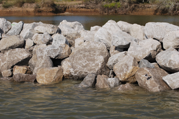
The completed Mad Island Shoreline Protection Project provides an offshore rock breakwater parallel to the existing shoreline for a distance of approximately 1.8 miles along the most sensitive portion of the shoreline. The breakwater was placed off the existing shoreline to maximize marsh development behind the structure while realizing a cost savings based on the shallow depth of the water in relation to the necessary construction height of the breakwater. The breakwater is composed of 100% C Stone (400 lb) at an average height of 3.5 feet with a 4-foot crown and a slope of 2.5 feet. The completed project creates a permanent offshore breakwater that substantially reduces wave energy along the GIWW shoreline of Mad Island and stabilizes the shoreline from further erosion. The breakwater protects the adjacent inland marshes and freshwater ponds from further saltwater intrusion and wetland habitat loss. The project also provides an area between the offshore breakwater and the current shoreline for future re-establishment of intertidal emergent marsh habitat through the natural build up of suspended sediment through the rocks or carried over the breakwater by tides or waves. A healthy and well-established marsh will further enhance the effectiveness of the breakwater structure.
This project represents many years of effort by key agency and partner staff to finally see this project to completion. The majority of the funding came from a successful grant from the Coastal Impact Assistance Program (CIAP). But a special thank you goes to the Texas Chapter of The Nature Conservancy and especially Mark Dumesnil. This project would not have been completed without Mark's long term commitment to the project. He is truly a dedicated conservationist Jeff Raasch is the Wetland and Joint Venture Project Leader for TPWD working out of Austin. Matt Nelson is CCWEP working out of Bay City.
Jeff Raasch is the wetland and joint venture project leader for TPWD working out of Austin. Matt Nelson is CCWEP working out of Bay City.
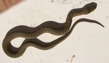
Population Status of the Brazos Water Snake
By Nathan Rains
The Brazos water snake is considered to be a riffle habitat specialist. As water levels and flow can change dynamically as water is release from reservoir dams along the Brazos, this can decrease riffle habitat available to the species. The Brazos River also receives high levels of recreational use and the shallow, riffle habitats are often the preferred campsites for canoers. This can lead to encounters that are detrimental to the Brazos water snake since they often lead to the death of the snakes.
Texas Parks and Wildlife, working alongside researchers from the Fort Worth Zoo and the University of Texas at Arlington have just begun a study of the population status of the Brazos water snake. We will be surveying a 20 mile section of the upper Brazos River just below Possum Kingdom reservoir. We will use a mark-recapture study to collect snakes over the next 3 summers. This method uses recapture rates and age class data to provide estimates of population size and recruitment rates. To conduct these surveys, we will canoe the selected section of the Brazos River looking for snakes basking on rocks and swimming near the water's edge. Brazos water snakes are rarely found more than a few feet from the river. We will also stop at all riffle habitats to search under rocks for adults and juveniles. When snakes are captured, we will record size, gender, and body temperature. Small tissue samples and a GPS location will be collected. In adult snakes, a passive integrated transponder (PIT) tag will be implanted under the skin. Upon recapture, we will be able to identify each snake individually. The surveys will be conducted from April thru October when snakes are active.
Hopefully this study will not only provide a better assessment of the current population status of the Brazos water snake but also provide more information regarding their biology and life history. This information will lead us to better conservation of a rare reptile found only here in Texas.
Nathan is a Wildlife Diversity Biologist with Texas Parks and Wildlife Department working out of Cleburne, TX.
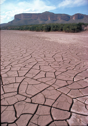
2011 Drought Impacts on Habitat and White-tailed Deer
By Alan Cain
With so many species relying on the woody plant communities, managing deer populations is a very important aspect of habitat management. Browsing of woody plants by white-tailed deer, exotic deer, and livestock can have tremendous impacts on native habitats and those negative impacts are magnified during times of drought. The effects of excessive browsing could lead to reduced plant health, increased susceptibility to disease or insect damage, and decreased plant reproduction and seedling establishment. Long term these stresses could lead to the disappearance of some plant species and an overall decline in the quality of the habitat and the ability of that habitat to support wildlife populations.
Maintaining deer populations in balance with the available native habitat helps to sustain not only the deer population itself but also that habitat. The state's nearly 700,000 deer hunters play a key role in habitat management and helping the Texas Parks & Wildlife Department manage the 4 million white-tailed deer in Texas. Keep in mind that the same native plant communities that support our game species such as deer and quail also support a plethora of non-game wildlife. During droughts as plant communities become stressed and are not capable of handling excess browsing by deer, harvest management becomes a necessity. In a year such as this hunters should make every effort to fill their license tags and meet harvest recommendations prescribed by TPWD's wildlife biologist for each region of the state. Hunters should focus on antlerless deer harvest in order to reduce deer populations. After all, does are the reproductive segment of the deer herd often producing singles and twins even in marginal conditions. Hunters are also encouraged to try to harvest deer early in the season to get "mouths off the range" as soon as possible rather than prolong possible impacts to the native habitat by holding off harvest until late in the season. Long-term, the white-tailed deer, and other game and non-game wildlife as well as the native habitats will benefit from a reduction in deer numbers.
Some hunters may worry that harvesting deer during the drought would decimate deer populations, but that is the perfect time to reduce numbers. By reducing deer numbers to appropriate levels we insure there are adequate forage resources available to meet the nutritional needs for the remaining deer. In addition, deer are highly reproductive animals and their populations can grow quickly with the return of a normal or wet year. The biggest mistake hunters and manager make is letting the deer herds grow to a number so large it becomes difficult to control through harvest. Consequently, these places often see damage to the native habitat as well as wide unwanted population crashes.
So what impacts does the drought have on deer themselves and what can deer hunters expect in the 2011 season? Everything from antler quality and fawn production, to general survival will be affected by the tough range conditions this year. Atop of every hunter's mind this year is how antlers will be affected by the drought. The 2011 season will pale in comparison to the 2010 season where 2 state record whitetails were harvested. Hunters can expect antler quality to be below average and much lower than last year. That's not to say there aren't some good bucks out in the woods this year. Those ranches managing habitat properly, keeping deer populations in check and maybe providing a little supplemental feed will not see as large a decrease in antler quality as other places not managing or on poor ranges. By managing habitat properly many ranches can moderate some of the effects of drought on antler quality. Any buck with a good set of antlers this year is one that has great potential, especially a young buck, and hunters may consider passing that type of deer up. Just think if a buck can grow a good set of antlers on the native range under these conditions what could he do on a good year. Hunters should see a good number of 1 1/2 year old bucks as many areas of the state experienced a good fawn production year in 2010 and those buck fawns from last year will now be sporting their 1st set of antlers this fall. In addition, 2005 was a good fawn production year based on surveys conduct by TPWD wildlife biologist and those 2005 buck fawns are now 6 1/2 years old. Hopefully, a number of these mature bucks will show up in the harvest this year. As mentioned earlier in the article hunters should try to make a good effort to harvest as many does as possible in addition to bucks. Organizations such as Hunters For the Hungry and Farmers and Hunters Feeding the Hungry can help distribute venison to needy folks when your freezer is full and you have no place to take harvested deer.
Fawn production doesn't look promising this year. In many areas it is likely to be below 20% and in single digits for some of the most drought stricken regions of the state. Fawns are especially susceptible to heat stress could greatly impact fawn survival. These young deer can become dehydrated quickly and good milk production from the doe is critical. In addition, fawn cover is critical this summer. Temperatures at the soil surface can be excruciatingly hot. I've been on ranches in South Texas during my graduate school work collecting vegetation samples where the soil surface was nearly 140F. These sites were severely overgrazed with little cover and sparse shrubs and mesquites providing little shade. In these environments fawn survival is dismal. This is why good habitat, providing shade and cooling areas, is critical during summers and very important this summer.
Lately, I've heard concerns from hunters about die-offs of adult deer related to the drought. While this is quite possible, keep in mind deer have survived through some pretty tough time including the drought of the 1950s. Deer are adapted to be able to handle drought and heat, but these stress periods can take a toll on deer populations, especially in areas where deer populations are already exceeding the carrying capacity of the native range. As deer become stressed they are more susceptible to infections or other disease. Drought like this can be a contributing factor towards stress. As with many wildlife species the very young and the very old often have much more difficult times dealing with extreme weather events. Healthy deer are likely to withstand stresses from drought and heat and that is why habitat management and deer population management are so important for maintaining healthy deer populations.
This year I would encourage hunters to get outdoors and take advantage of the fantastic deer hunting opportunities Texas has to offer and fill your freezer with some tasty and very healthy venison. With nearly 4 million white-tailed deer in Texas the opportunities for harvest have never been better. Through proper deer harvest and sound habitat management we will insure native habitats are always present to support the wildlife populations that Texans so greatly enjoy.
Alan Cain is the white-tailed deer program leader working out of Pleasanton.
Texas Rivers
By Cindy Loeffler
The Texas Legislature has taken steps aimed at protecting aquatic ecosystems. In 1997 Senate Bill 1 became law, creating the regional water planning process. Regional water planning groups, which include a nonvoting member from TPWD, prepare 50 year water plans that also consider environmental impacts. The planning groups also have the option of recommending to the Legislature that rivers meeting certain criteria be designated as "ecologically unique", making them off-limits to reservoir construction. Several rivers and streams now have that designation and several more have been nominated. In 2001 Senate Bill 2 was enacted, directing TPWD, TCEQ and TWDB to determine flow conditions necessary for maintaining healthy rivers and streams. This led to the creation of the interagency Texas Instream Flow Program, which in turn developed study methodologies that have received the seal of approval from the National Academy of Sciences. Instream flow studies to identify flow regimes necessary to protect water quality, provide habitat and maintain channel features including riparian areas are now underway in the Sabine, Trinity, Brazos and San Antonio River Basins. The deadline for study completion is 2016. More information can be found at http://www.twdb.state.tx.us/InstreamFlows/index.html.
Under the Texas Water Code, entities wishing to divert and use water from Texas rivers must be granted a permit from the TCEQ. Most water rights were issued prior to 1985 and have no environmental protection. Of the estimated 7500 rights that have been granted, fewer than 15% include environmental restrictions to protect streamflows. To address this situation in 2007 the Texas Legislature passed Senate Bill 3 which established a statewide science-based, stakeholder-driven process to protect environmental flows. The Environmental Flows Advisory Group, which includes a member of the TPWD Commission, oversees the process. The Science Advisory Committee provides technical guidance to the science teams appointed for each basin. TPWD staff have and will continue to provide technical expertise to these groups to develop technical guidance and provide support neccesary to identify environmental flow regimes adequate to support a sound ecological environment. To date TCEQ has established environmental flow standards for the Sabine, Neches, Trinity and San Jacinto Basins. More information on the SB3 environmental flows process can be found at http://www.tceq.state.tx.us/permitting/water_supply/water_rights/eflows/group.html.
Streamflow is just one of the factors that can affect a species living in Texas rivers. Texas rivers are taking a beating in the current drought. Texas is now in the midst of its most severe one-year drought on record, according to State Climatologist John Nielsen-Gammon. Preliminary reports from the National Climatic Data Center indicate that July 2011 was the hottest month ever recorded for Texas, with data going back to 1895. US Geological Survey streamflow gages for much of the state are registering well below normal streamflow. Streamflows in some areas are in the 10th percentile or lower range, indicating severe hydrologic drought. Low flows are limiting available habitat for some aquatic species, and producing water quality concerns due to high temperatures and low flow conditions. Information about current drought and streamflow conditions can be accessed at the USGS WaterWatch website: http://waterwatch.usgs.gov/new/index.php?id=ww. TPWD is keeping an eye on the sky, praying for rain and hoping all of our efforts to protect Texas rivers will be enough as the Drought of 2011 persists.
Cindy is Water Resources Branch Chief working out of Austin for Texas Parks and Wildlife Department.
 1,500-Acre Marsh Restoration Project at J.D. Murphree WMA
A Public-Private Conservation Effort
By Andi Cooper and Greg Green - Ducks Unlimited, Mike Rezsutek - TPWD
The Salt Bayou Unit of J.D. Murphree Wildlife Management Area near Port Arthur, Texas, managed by the Texas Parks and Wildlife Department, is the site of an approximately 1,500-acre restoration project. This project happened through the efforts of four major players; NOAA Fisheries, Texas Parks and Wildlife Department, Golden Pass Liquefied Natural Gas (GPLNG), and Ducks Unlimited. It is one of the largest beneficial use projects of its kind in Texas, but not the first time beneficial use occurred on the J.D. Murphree WMA. A smaller project as mitigation for wetland impacts completed in 2008 acted as the template for this larger project.
The wildlife management area provides important stopover and staging habitat for many of the waterfowl in the Central Flyway that migrate and winter along the Texas Gulf Coast. The Salt Bayou Unit also provides valuable habitat to Mottled Ducks, a resident species whose declining population in Texas has caused concerns within the waterfowl conservation community.
Due to saltwater intrusion and subsidence, the Salt Bayou Unit has degraded over the years, reducing the amount of emergent vegetation that provides the foundation for fisheries, birds, amphibians and reptiles, and mammals inhabiting the marsh. Scouring storm surges and other impacts from hurricanes have further degraded this marsh complex. Once areas lose their vegetation, they also lose many of their benefits to wetland-associated fish and wildlife.
In an attempt to reverse this loss, TPWD worked with GPLNG and DU to place as much as 24 inches of dredge material in subsided marsh to raise elevations to desirable levels. This effort will accommodate the re-establishment and growth of native wetland vegetation while maintaining ponds and other surface water features important in a properly functioning marsh. The dredge material was filling in the GPLNG berth along the Sabine Neches Waterway, and would have been put in upland disposal otherwise. The three partners saw a win-win opportunity for GPLNG to use that material to help restore marsh and provide cost savings to GPLNG at the same time.
The project didn't start out as the large-scale restoration seen today. Originally, a National Oceanic and Atmospheric Administration's Fisheries Hurricane Ike Recovery Grant to TPWD proposed to restore 40 acres of emergent marsh habitat damaged by storm impacts. The $1.5-million grant enabled TPWD to hire DU for planning, engineering, surveys and monitoring of the small project. The grant also covered part of the costs of replanting marsh vegetation on the restoration site.
During the initial planning stages of the project, an opportunity to partner with GPLNG developed. Maintenance dredging of GPLNG's berthing terminal presented the possibility to beneficially use more than 2 million cubic yards of dredge material. TPWD asked DU to survey and develop a design for the project and to oversee the placement of the dredge material during the construction phase. Ultimately, nearly 1,500 acres of coastal marsh was enhanced by this partnership - a substantially greater benefit than the 40 acres originally proposed to NOAA. This project created a partnership that delivered far more wetlands improvement than planned, and one that should serve as the standard for future beneficial use projects. Funding from NOAA did not pay for the dredging itself, but will be utilized to plant much more than 40 acres of restored marsh.
"We've worked with DU for many years, and we know their expertise in wetlands restoration," Jim Sutherlin, area manager for J.D. Murphree, said. "This area has long been important for waterfowl and other wildlife, and we want to ensure that it continues to provide quality habitat. We appreciate our relationship with Golden Pass and the special efforts they are making to provide the fill material needed for restoring the marsh."
"We value the opportunity to work with Texas Parks and Wildlife, Ducks Unlimited and Jefferson County in bringing this important restoration project to fruition," Raymond Jones, president of Golden Pass LNG, said. "By revitalizing our existing coastal marshes, we are providing wintering waterfowl and other wildlife with the types of natural habitats that promote long-term viability. We look forward to pursuing additional opportunities in the future."
"Golden Pass LNG could have taken a more traditional and dependable route by placing the dredge material in a containment area. The fact that they not only considered using the material in a positive way, but actually encouraged and paid their dredging contractors to do whatever was necessary to make the project work best for marsh restoration deserves much credit and attention," said DU regional biologist Greg Green. "At a time when corporations can be considered to have little environmental stewardship, it is encouraging for Golden Pass to participate in the project in this way of their own volition."
Large-scale restoration of coastal marshes requires significant investment from local, state and federal agencies, non-profit organizations and private citizens. There are many methods for marsh restoration and habitat conservation, but beneficial use projects are one of the few that can create habitat in a cost-effective way. In some situations, beneficial use projects can cost less than traditional dredge placement projects due to a reduction or elimination of disposal fees imposed by the owner of a contained placement site.
"We need more beneficial use projects along the Gulf Coast," DU regional biologist Greg Green said. "Large-scale restoration is the only option if we are going to ensure the legacy of this region as important waterfowl wintering habitat."
"Jefferson County wholeheartedly supports marsh restoration and is actively pursuing opportunities to promote more of these types of projects for our area," Jefferson County Judge Elect Jeff Branick, said. "Coastal marshes protect coastal communities and are vital to preserving the recreational heritage of our area."
By Andi Cooper and Greg Green - Ducks Unlimited, Mike Rezsutek - TPWD
Beneficial Use of Dredge Material
Dto growing scientific knowledge and public awareness of using dredged material as a valuable resource for wetland restoration and renourishment, beneficial use of dredged material has become a viable option to traditional "dredge and contain" methods for waterway maintenance projects. Marsh restoration projects that utilize beneficial use of dredge material can mimic natural geomorphic and hydrologic processes that have been altered or completely terminated. For instance, rivers and waterways that have been leveed to provide dependable venues for shipping traffic and commerce have been altered in way that natural flood events cannot replenish adjacent marshes with nutrient-rich, sediment-laden flood waters. Beneficially using dredge material created from river maintenance projects can provide a means of sustaining marsh values in some areas. Open disposal of dredge material is highly unfavorable within the conservation community, and can be considered a complete waste of a valuable resource.
The placement of dredged material is managed and conducted by federal, state and local governments; private entities; and semi-private entities, such as port authorities. The U.S. Army Corps of Engineers issues permits for the placement of dredged material, while the role of the U.S. Environmental Protection Agency is to provide oversight in the permitting process. Beneficial uses of dredged material may make traditional placement of dredged material unnecessary or at least reduce the level of placement. Economic, social and other benefits can result from the productive use of dredged material. However, monitoring of the restoration sites is critical for achieving success.
Wetland restoration using dredged material can be accomplished in several ways, but is dependent upon the characteristics of the material being used. For example, silty, fine dredge material can be applied in thin layers to bring degraded wetlands up to an intertidal elevation, as has been done extensively in south Louisiana. Sandy, heavy, sediment-laden dredge material can be de-watered and used in wind and wave barriers to allow native vegetation to re-grow and restore the viability of a wetland. Dredged material sediment can be used to stabilize eroding natural wetland shorelines or to nourish subsiding wetlands. Dewatered dredged material can also be used to construct erosion barriers and other structures that aid in restoring a degraded or impacted wetland.
Dredged material has been extensively used to restore and establish wetlands. Where proper sites can be located and government and private agency cooperation can be coordinated, wetlands restoration is a relatively well-established and technically feasible use of dredged material.
On The Back Porch - The Playa Lakes
By Ruben Cantu
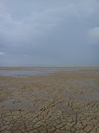
Iremember daydreaming on a flight from Dallas to Denver, when the pilot announced that we were just over Amarillo. Peering out the window, for the next several minutes I was in awe at the number of playa lakes one could see via the early morning light - they looked to be everywhere. With about 19,000 of them found in Texas, playa lakes are truly the gems of the Panhandle, especially when they glitter at you like diamonds from an altitude of 40,000 feet. And those diamonds play a valuable role to our native Panhandle wildlife, migratory birds and to the recharge of the Ogallala aquifer in the Panhandle region of Texas.
Playas, as they are often called, are quite unique in that they are freshwater wetlands of the High Plains region of the Western Great Plains. These shallow wetlands have clay-lined (Randall Clay in the panhandle) basins and because they are the lowest point of a closed watershed they fill seasonally with water from rainfall and its associated runoff from surrounding areas. While there is no official count of playa lakes, it has been estimated that there are about 60,000 playas found in the Western Great Plains and we have the lion's share of them.
Theories abound on how the playas came to be. The one I like the most is that they are the result of millions of bison wallowing in the same areas over and over again over the years. Just because I like it doesn't mean its fact. Among the other theories of playa development are karst topography, land subsidence, isolation of early pluvial lake and rivers, soil slumpage, wind deflation, and meteor impact. While there are various theories on playa formation, the more popular theory attempting to explain playa formation is the dissolving of calcic soils that underlie the High Plains.
Regardless of how they are developed, their existence in the Panhandle and their importance to the area is without question. Playas are the center of biodiversity on the plains, supporting more than 200 species of birds and other wildlife. Playas are also the primary source of recharge for the Ogallala Aquifer, a 174,000 square mile groundwater formation that supplies nearly 100 percent of the High Plains water needs. Recharge value and relationship with the Ogallala. The results from most published studies indicate that recharge rates beneath playas are substantially higher than recharge rates beneath interplaya settings. Playas are important zones of recharge to the Ogallala and are not just evaporative pans as many believe they are.
I think we can all recognize the importance of Playas to wildlife, especially migratory waterfowl like ducks, geese, and sand hill cranes, when we see them with water in their basins. But it doesn't stop there, even when dry they are extremely important components to wildlife habitat. I remember my first pheasant hunt in the Texas Panhandle. Our "hunting party" wasn't going to hunt the traditional cut sorghum and corn fields… we were going to hunt playa bottoms. Oh yeah, we found pheasant occupying these playas but we also found mule deer, white-tailed deer, barn owls, great horned owls, marsh hawks, ravens, crows, meadowlarks, killdeers, numerous kinds of field sparrows, raccoons, skunks, rats, mice, rabbits, bob white quail, and more. Just goes to prove that these playas, wet or dry are important features in the landscape for Panhandle wildlife, all kinds.
Playas, native grasslands, wetlands, rivers and streams are the most ecologically valuable lands in the Panhandle region of Texas. Together they provide habitat for a myriad of plants, mammals, insects and amphibians and of course populations of resident birds, waterfowl, shorebirds and other migratory birds.
Playas are critically threatened wetlands. Collectively, some of these habitats have been lost to the point where native wildlife dependent upon them have declined in population, including Mountain Plovers, Lesser Prairie-Chickens and Northern Pintails. Habitat loss is caused by a number of factors, including sedimentation, conversion of land to agricultural use, residential development, overgrazing, municipal and energy development, filling and pitting of wetlands, damming of rivers and streams, and encroachment of non-native, invasive plant species.
Because of silting in, deep plowing and other impacts, researchers estimate that more than 70 percent having been altered from their natural state, many of these buried by sedimentation. Maintaining native prairie grasses around playas, or if playas are in cropland, planting native grass buffers around them, is the best way to conserve these important wetlands and protect them from sediment build-up.
Playas are the most numerous and pervasive wetland habitat in the region and therefore critical to wildlife health and survival as well as the primary source of recharge for the Ogallala Aquifer. The latter being critical to the sustainability of the people and the agricultural way of life in the Texas Panhandle.
If you want to know more about playa lakes, their conservation and management check out the Playa Lakes Joint Venture website at http://www.pljv.org This joint venture is a non-profit partnership of federal and state wildlife agencies, conservation groups, private industry and landowners dedicated to conserving bird habitat in the Southern Great Plains.
Ruben is the Regional Director for Wildlife Region 1 working out of San Angelo.


