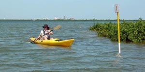
South Bay Paddling Trail
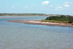
The South Bay Paddling Trail follows the shores of South Bay in a loop of about eight miles. This pristine, shallow, subtropical body of water consists of approximately 3,500 surface acres, bounded on the south by the riparian edge of the Rio Grande, on the north by the Brownsville Ship Channel and associated spoil banks, and on the east by Brazos Island. It is located in Cameron County.
- Getting There
- Maps
- Trail Description
- Safety
- Fishing
- Wildlife & Ecology
- Events
- Partnership
- Rentals & Shuttles
Getting There
- Port Isabel and South Padre Island are accessible via U.S. Highways 77, 281 or 83.
- Take Interstate 37 South from San Antonio to U.S. Hwy. 77 south, then east on Texas Hwy. 100 approximately 28 miles.
Put-in and Take-out:
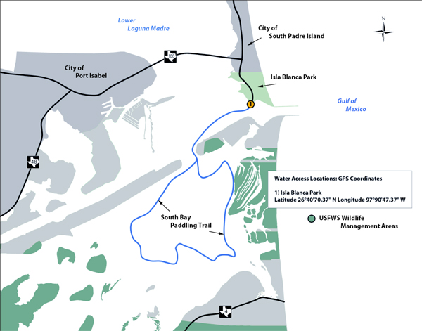
Paddlers must make a short, open-water transit to reach South Bay. There is only one launch site at this time:
- Isla Blanca Park
Padre Boulevard, south of Queen Isabella Causeway
South Padre Island, 956-761-5493 - Marker 1 on the South Bay Paddling Trail may be found at
 26° 02' 55.032" N, 97° 10' 53.292" W
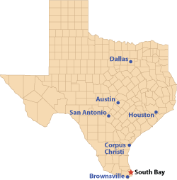
Distance from nearest major cities:
- McAllen - 69 miles
- Corpus Christi - 167 miles
- Laredo - 212 miles
- Monterrey, Mexico - 225 miles
- San Antonio - 285 miles
- Austin - 340 miles
- Houston - 367 miles
Maps
View Global Positioning System (GPS) points for South Bay
Road Map to South Bay Paddling Trail - Click to view PDF  (PDF 17.8 MB).

Color Satellite map of South Bay. Click to view PDF (PDF 78.4 KB). This map is also available in a durable laminated version from select retailers. To get a list of these retailers contact Shoreline Publishing at 713-973-1627.
Trail Description and Landmarks
 Trail Length: 8 miles
Paddling Time: 2-5 hours
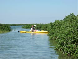
Due to its unique ecological features, South Bay was designated a Coastal Preserve in 1984. In addition to its extensive seagrass beds and stands of black mangroves, it also supports the only significant population of Easter Oysters south of Corpus Christi Bay. Because this is an extremely shallow bay, there is very little large boat traffic. Two interesting physical characteristics of South Bay are the “Table Top,” a very shallow flat covered by seagrass in the North West quarter of the bay, and the old Boca Chica channel that was the outlet for the Lower Laguna Madre to the Gulf before the ship channel was cut.
Safety
Because of the many oysters in South Bay, it is particularly important for paddlers to wear adequate footgear while using the area. While shallow, the presence of large numbers of shellfish alternating with sometimes silty, mucky bottoms make this bay unsuitable for wadefishing.
This is a remote paddling trail with no easy vehicle access. Take plenty of water and sunscreen. While launching on the north side of the Brownsville Ship Channel, be aware that large vessels often are moving much faster than they appear to be and have right-of-way in the channel.
Fishing
Fishing in South Bay is outstanding, with spring, summer and fall providing the greatest diversity and abundance of fish. Anglers can expect to encounter red drum, spotted seatrout and flounder here. Common snook and fat snook are routinely caught in South Bay’s shallow waters, as are jack crevalle, gray snapper and ladyfish.
Wildlife and Ecology
 Due to its unique ecological features, South Bay was designated a Coastal Preserve in 1984. In addition to its extensive seagrass beds and stands of black mangroves, it also supports the only significant population of Easter Oysters south of Corpus Christi Bay. Because this is an extremely shallow bay, there is very little large boat traffic. Two interesting physical characteristics of South Bay are the “Table Top,” a very shallow flat covered by seagrass in the North West quarter of the bay, and the old Boca Chica channel that was the outlet for the Lower Laguna Madre to the Gulf before the ship channel was cut.
South Bay and its wind-tidal flats, shallow depths, associated vegetation and unique location provides excellent feeding, resting and wintering habitat for numerous types of migratory bird species, such as White Pelicans, Brown Pelicans, Cormorants, Gadwalls, Green-winged Teals and Redheads. A variety of shorebirds and wading birds may be seen year-round, and the extensive black mangrove stands are an important nesting area for roseate spoonbills.
South Bay is encircled by the Lower Rio Grande Valley Wildlife Refuge, which is known to support a population of rare Texas ocelots. Coyotes, bobcats, armadillos, raccoons and other small mammals are common on the shores of the bay.
Paddling Trail Events
See TPWD Calendar for Paddling Events
Partnership
TPWD is currently seeking partners to help maintain the South Bay Paddling Trail. If you are interested, please contact Paul Hammerschmidt at paul.hammerschmidt@tpwd.state.tx.us or by phone at 512-389-4650.
Rentals & Shuttles
South Padre Island Kayak Enterprises
P.O. Box 3861South Padre Island TX 78597
956-525-0010
Services offered: Half or Full day kayak rentals with free delivery and pick-up. Single or tandem boats available with various models to choose from – seat, paddle, PFD, and safety whistle provided with rental.
South Padre Island Water Sports, LLC
5709 A Padre Blvd.South Padre Island TX 78597
956-299-9463
southpadreislandwatersports.com