Fishing
- Licenses & Regulations
- ShareLunkers
- Fish Identification
- Fish Consumption
- Texas Freshwater Fisheries Center
Water Resources
- Texas Reservoir Levels
- US Army Corps of Engineers
- Texas Water Issues
- Golden Alga
- Aquatic Vegetation
8684 LaVillage Avenue
Waco, Texas 76712
(254) 666-5190
Michael Baird, Biologist
Nearby State Park
Lake Mexia
Quick Links: Fishing Regulations | Angling Opportunities | Cover & Structure | Tips & Tactics
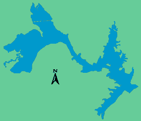
Lake Characteristics
Location: On the Navasota River, seven miles west of the City of Mexia off
US 84
Surface area: 1,048 acres
Maximum depth: 20 feet
Impounded: 1961
Water Conditions
Current
Lake Level
Conservation Pool Elevation: 448.3 ft. msl
Fluctuation: 1-2 feet
Normal Clarity: Murky to turbid
Reservoir Controlling Authority
Bistone Municipal Water District
472 Whiterock Drive
Mexia, Texas 76667
(254) 562-5922
Aquatic Vegetation
Waterwillow, lotus, cattail, cutgrass, pondweed
Predominant Fish Species
Lake Records
Stocking History
Latest Survey Report
Lake Maps
None available
Fishing Regulations
All species are currently managed with statewide regulations.
Angling Opportunities
| Species | Poor | Fair | Good | Excellent |
|---|---|---|---|---|
| Largemouth Bass | ||||
| Channel Catfish | ||||
| Blue Catfish | ||||
| Crappie | ||||
| White Bass | ||||
| Sunfish |
Fishing Cover/Structure
Lake Mexia is a very turbid, shallow lake, and the majority of good habitat is in the lower end of the lake. Boat docks, piers, and shallow aquatic vegetation hold fish year round.
Tips & Tactics
Largemouth bass fishing is best around docks and vegetation using a variety of baits. Crappie fishing is excellent around docks, bridge pilings, and submerged brush using minnows. Catfishing for channels and blues is generally best tightlining with shad or cut bait, although prepared baits also work well. White bass are generally slow, with tailspinners and jigs producing modest catches around windy points.