Commission Agenda Item No. 6
Presenter:
Ted Hollingsworth
Action
Grant of Easement – Jefferson County – Approximately 8 Acres at
J.D. Murphree Wildlife Management Area
May 26, 2016
I. Executive Summary: Texas Parks and Wildlife Department (TPWD) has been working with Jefferson County Flood Control District No. 6, Ducks Unlimited and local landowners on an agreement to improve the district’s ability to manage water levels on lands near the J.D. Murphree Wildlife Management Area.
II. Discussion: The 24,498-acre J.D. Murphree Wildlife Management Area (WMA), located on the Chenier plains and marshes of the southeast Texas coast, protects a vast mosaic of freshwater, intermediate and tidal wetlands, including lakes, bayous and marshes. Construction of the Gulf Intracoastal Waterway (GIWW) through the heart of this landscape significantly altered the hydrology of the entire system. Over the years, numerous levees, canals, and water control structures have been constructed in order to manage water quality, quantity and seasonality across this landscape to ensure long-term viability, productivity and native diversity.
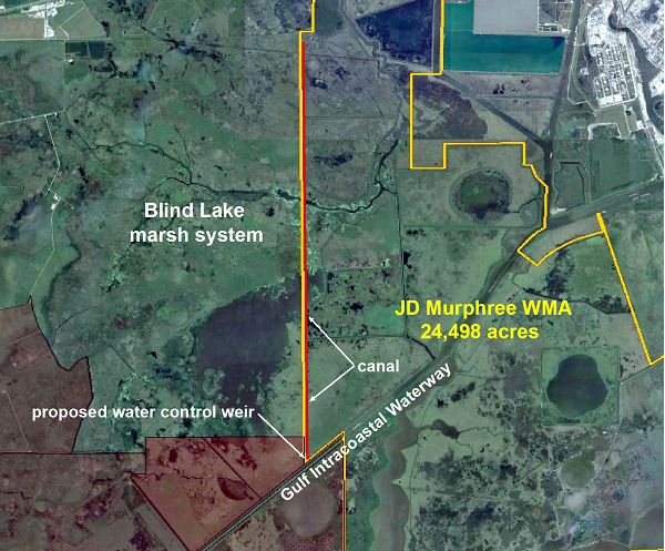
Because of the relatively flat topography, differences in water levels of a few inches can significantly alter extensive wetland systems. In and adjacent to the north end of the WMA, a large freshwater marsh has been suffering the effects of too much water. Five private landowners, representing about 4,500 acres of marsh, have been working with the Jefferson County Drainage District No. 6, Ducks Unlimited and TPWD on a strategy and associated agreements that would result in the District’s ability to drain water from this system more effectively. The agreements are intended to achieve and maintain seasonal water levels that are ideal for the health and productivity of the marsh, especially in light of its value to resident and migratory waterfowl and wading birds.
In order to achieve the desired level of control over water levels, the District requests an easement over an existing TPWD canal that would drain water from north to south and currently terminates near the GIWW. In addition, the requested easement would allow construction of a water control structure to allow water in the canal to be drained into the GIWW.
III. Recommendation:
“The Texas Parks and Wildlife Commission adopts the Resolution attached as Exhibit A.”
Commission Agenda Item No. 6
Exhibit A
A Resolution by the Texas Parks and Wildlife Commission Regarding the Grant of an Easement Over an Area of Approximately 8 Acres at the J.D. Murphree Wildlife Management Area in Jefferson County
Resolution
Whereas, Texas Parks and Wildlife Department (TPWD) owns and manages the J.D. Murphree Wildlife Management Area (the WMA), comprising approximately 24,498 acres of coastal wetlands and associated habitats in Jefferson County; and,
Whereas, staff of the TPWD and the WMA have been managing water levels on much of the WMA for decades to maximize diversity and productivity of native habitats and species; and,
Whereas, the topography and landscape position of the WMA is such that operation of canals and water control structures on the WMA can affect the management and drainage of water on the WMA and adjacent private lands; and,
Whereas, staff of the WMA have worked closely with the Jefferson County Drainage District No. 6 (DD6), Ducks Unlimited (DU), and owners of private lands that make up the Blind Lake marsh system, on strategies and agreements for the management of water in that system; and,
Whereas, TPWD, DD6, DU and the above-reference private landowners share a common goal of managing seasonal water levels in the Blind Lake marsh system for optimum biological health of that system; and,
Whereas, Ducks Unlimited has received a grant to pay for improvements to an existing canal and installation of a new water control weir on land within the WMA needed to implement these agreements; and,
Whereas, the land occupied by the subject canal and water control weir would occupy approximately 8 acres of the WMA; and,
Whereas, in order to implement the above-referenced agreements, DD6 will need an easement for the management of the canal and water control weir on the WMA; and,
Whereas, the Texas Parks and Wildlife Commission (the Commission) finds that as required by Parks and Wildlife Code, Chapter 26, notices of today’s hearing of this matter were published at least once a week for three consecutive weeks in a newspaper of general circulation which is published at least six days a week in the community nearest to the Subject Tract in which such newspapers are published (Beaumont Enterprise in Jefferson County), with the last day of publication being not less than one week or more than two weeks before the date of today’s hearing and that such notices specified the date and time at which the Commission would hear testimony regarding the proposed easement; and,
Whereas, the Commission finds, in accordance with Parks and Wildlife Code, Chapter 26, that (1) there is no feasible and prudent alternative to the use or taking of approximately 8 acres of TPWD land which would be eased to DD6 for the purposes described above; and, (2) the program or project that requires the use or taking of land includes all reasonable planning to minimize harm to TPWD property; and,
Whereas, the Commission finds, in accordance with Section 11.301 of the Texas Parks and Wildlife Code that TPWD will receive conservation benefits of value in exchange for the easement, and that granting of an easement is in the best interest of TPWD; and,
Now, therefore, the Texas Parks and Wildlife Commission authorizes the Executive Director to take all necessary steps to grant an easement to the Jefferson County Drainage District No. 6 for the purposes and subject to the conditions described herein and in the motion approved in this Resolution.
Adopted and approved this 26th day of May, 2016.
______________________________________
T. Dan Friedkin, Chairman
______________________________________
Ralph H. Duggins, Vice-Chairman
______________________________________
Anna B. Galo, Member
______________________________________
Bill Jones, Member
______________________________________
Jeanne W. Latimer, Member
______________________________________
James H. Lee, Member
______________________________________
S. Reed Morian, Member
______________________________________
Dick Scott, Member
______________________________________
Kelcy L. Warren, Member
Commission Agenda Item No. 6
Exhibit B
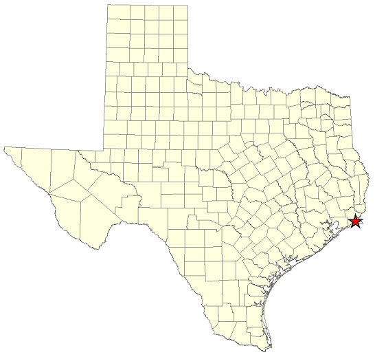
Location Map for J.D. Murphree WMA in Jefferson County
Commission Agenda Item No. 6
Exhibit C
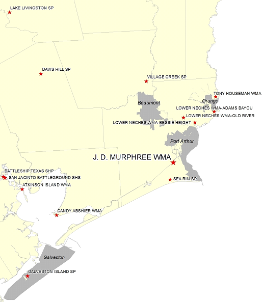
Vicinity Map for the J.D. Murphree WMA – 5 Miles South of Port Neches
Commission Agenda Item No. 6
Exhibit D
Site Map Showing Location of Canal and Weir