Saltwater Freeze Events
Whenever water temperatures on the coast are predicted to fall below 40°F, the TPWD executive director may close one or more of the sites listed below for saltwater fishing until the threat from the freeze event is over. This NOTICE OF CLOSURE will be posted online and shared with news and social media.
Coastal Areas That May Be Closed To Fishing During Freeze Conditions
If you have questions about your fishing area during a freeze event, please watch your local newspaper or call the nearest TPWD Law Enforcement Office.
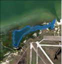
Army Hole
Closed Area: On Matagorda Island, the enclosed waters between the Matagorda Island WMA docks and Pringle Lake.
Nearest city: Port O'Connor
County: Calhoun
Barney Davis Outfall
Closed Area: From the outfall structure extending northeast 200 meters, including all waters of the outfall channel.
Nearest city: Corpus Christi
County: Nueces
Bay Harbor Canals
Closed Area: All waters of the Bay Harbor Canals extending to the Intracoastal Waterway.
Nearest city: Matagorda
County: Matagorda
Bluff's Point Channel
Closed Area: All waters inside Bluff’s Point Channel extending eastward to a line extending from the tip of the southern breakwater to the tip of the northern breakwater.
Nearest city: Corpus Christi
County: Nueces County
Brazos Santiago Pass South Jetty
Closed Area: Gulf of Mexico from and including the Brazos Santiago Pass south jetty along the beach for one half statute mile and out from shore for 1,000 yards.
Nearest City: Brownsville
County: Cameron
Conn Brown
Closed Area: Entire harbor north and west of the ICWW.
Nearest City: Aransas Pass
County: San Patricio
Cove Harbor
Closed Area: Entire harbor west of the ICWW.
Nearest City: Rockport
County: Aransas
Entergy Outfall
Closed Area: Entire canal from the mouth of the canal at the Neches River Canal to the power plant.
Nearest City: Bridge City
County: Orange
Fulton Harbor
Closed Area: Entire harbor west of the seawall.
Nearest city: Fulton
County: Aransas
Gayman Channel/Bahia Grande
Closed Area: All the waters of Gayman Channel extending from the Brownsville Ship Channel to the waters of Bahia Grande that are accessible from Highway 48.
Nearest city: Port Isabel
County: Cameron
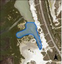
Harbor Island Hole
Closed Area: The deep waters and channel immediately west of Highway 361 on Harbor Island and south of a line beginning at N 27-51’-22.4” W 97-04’-57.5” and terminating at N 27-51’-22.4” W 97-04’-54.0”. Refer to map image for delineation and boundaries.
Nearest City: Port Aransas
County: Nueces
Port Lavaca Harbor Refuge
Closed Area: Entire channel from entrance to Lavaca Bay.
Nearest City: Port Lavaca
County: Calhoun
Humble Channel
Closed Area: The waters that are bounded by the northeastern side of the JFK Causeway extending southwest 220 meters from the John F. Kennedy Memorial Causeway. This area includes the waters surrounding both fishing piers along the Humble channel.
Nearest city: Corpus Christi
County: Nueces
Island Moorings
Closed Area: All waters within the Island Mooring canal subdivision including the access channel that extends from the Corpus Christi Ship Channel.
Nearest city: Port Aransas
County: Nueces
Little Bay
Closed Area: All waters and canals inside Key Allegro subdivision including Blevins Channel and Leggett Channel and all canals within the Harbor Oaks subdivision.
Nearest City: Rockport
County: Aransas
Matagorda Harbor
Closed Area: All waters of the Bay Harbor Canals extending to the Intracoastal Waterway.
Nearest City: Matagorda
County: Matagorda
Moses Lake
Closed Area: From Moses Lake to the Tide gate, to include the navigational channel up to the northern shoreline of Dollar Bay. Dollar Bay and Moses Bayou are not included.
Nearest Cities: Dickinson; Texas City
County: Galveston
Offats Bayou
Closed Area: All of Offats Bayou east of a line drawn from Marker 22 south to Scholes Airfield.
Nearest City: Galveston
County: Galveston
Padre Island Canals
Closed Area: All waters of the Padre Island Canal subdivisions including Lake Padre and Packery Channel.
Nearest city: Corpus Christi
County: Nueces
Palacios Shrimp Basin
Closed Area: Entire shrimp basin from the entrance to Matagorda Bay, including all turning basins and South Bay Marina.
Nearest City: Palacios
County: Matagorda
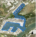
Pelican Cove/Bay Harbor
Closed Area: All waters of the Pelican Cove and Bay Harbor canal subdivisions, including the access channel for the Bay Harbor canal subdivision out to the Intracoastal Waterway.
Nearest city: Aransas Pass
County: Nueces
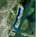
Peninsula Park Harbor
Closed Area: All waters of the Peninsula Park Harbor to the opening of the breakwater.
Nearest city: Port Lavaca
County: Calhoun
Port Isabel
Closed Area: All waters within the city of Port Isabel to include the deep water area to the east of the city in the Laguna Madre.
Nearest City: Port Isabel
County: Cameron
Port Lavaca Harbor (aka Evelyn's)
Closed Area: All waters of Port Lavaca Harbor to line starting at N 28⁰-37’-20.9” W 96⁰-37’24.6” extending east and terminating at N 28⁰-37’-21.0” W 96⁰-37’-18.1”.
Nearest city: Port Lavaca
County: Calhoun
Port Mansfield Harbor
Closed Area: Entire harbor from the corners of the bulkheads on either side of the harbor to the harbor mouth.
Nearest City: Port Mansfield
County: Willacy
The Racquet & Yacht Club and Kon Tiki
Closed Area: All waters and channels of the Racquet & Yacht Club development and Kon Tiki harbor.
Nearest City: Fulton
County: Aransas
Redfish Bay Subdivisioins
Closed Area:All water and canals of the City by the Sea, La Buena Vida, Island of Rockport, Bahia Bay, and Palm Harbor subdivisions west of the ICWW.
Nearest City: Rockport
County: Aransas
Rincon Subdivision
Closed Area: All waters of the Rincon canal subdivision including main access channel. Also includes second access channel to the west.
Nearest city: Corpus Christi
County: Nueces
Rockport Harbor
Closed Area: Entire harbor including the waters directly to the east of the seawall.
Nearest City: Rockport
County: Aransas
San Martin
Closed Area: : All waters of San Martin Lake including the access channel extending to the Brownsville Ship Channel.
Nearest city: Port Isabel
County: Cameron
Sea Gun Marina
Closed Area: Entire harbor inside the entryway seawall.
Nearest city: Lamar
County: Aransas
The Reserve
Closed Area: All waters and canals inside The Reserve subdivision.
Nearest city: Lamar
County: Aransas
The Shores
Closed Area: All waters of The Shores canal development including access channels from the eastern side of the Laguna Madre.
Nearest city: South Padre Island
County: Cameron
Tropical Isles
Closed Area: All waters of the Tropical Isles canal subdivision extending out the mouth of the access channel as it enters the Laguna Madre.
Nearest city: Corpus Christi
County: Nueces


