Clouds
Clouds, nature’s weather forecasters, have been forming in the same recognizable shapes and patterns since before man first lifted his eyes and gazed at the sky. Some people may think clouds are just beautiful blobs of some kind of white, fleecy substance that appear for no particular reason. Nothing could be further from the truth. There are several distinct types of clouds, and each has its own reason for being. However, before taking a closer look at these different kinds of clouds, let’s discover what clouds are made of and how they form.
Clouds are a collection of tiny droplets of water that have formed on microscopic air particles. They cannot form in perfectly clean air, but such a condition does not exist naturally anywhere on the earth. No matter how clean and clear the air around us may look, tiny particles are suspended in and moving with it. Occasionally we get a glimpse of some of the larger ones, called motes, as they dance around in the rays of sunlight shining through a window in a partially darkened room.
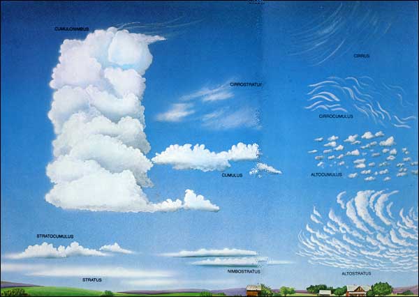
Illustration of the various types of clouds
(View
larger image.)
It is easy to understand that the air above many of our cities contains dust, smoke, and other less desirable particles, but it may be more difficult to believe that country air, which appears to be so clean, also contains these particles. Dust, pollen grains, powdery soil, and rock dust are some of the things suspended in country air. Air over the oceans has its share, too. It contains wind-blown particles from the land as well as tiny salt crystals from the water.
Water vapor (moisture in its gaseous state) also is suspended in air. We cannot see it or feel its wetness, but it is there all the same. When this water vapor condenses (turns to liquid), it becomes visible. Prove this scientific fact by breathing into a glass jar until tiny droplets of water from the moisture in your breath form on the inside. Screw on the lid and set the jar in a warm place. As the air in the jar warms, the moisture turns to vapor (evaporates) and disappears. You can’t see it, but it is still there. Set the jar in a cool place, and the water vapor will condense into droplets once again.
Clouds appear and disappear in a very similar way. When warm air rises from the earth’s surface, it begins to cool. When the air becomes cooler than the dew point temperature, the invisible water vapor it contains condenses on the suspended microscopic particles. Each particle acquires a cluster of water droplets. When enough of these clusters have formed, they become visible and a cloud appears.
As these clusters whirl and dart about within the cloud, they occasionally bump into each other and stick together, forming larger, heavier clusters. When enough clusters combine, they become too heavy to stay up in the air and fall as rain. If the cloud is high enough, the raindrops may evaporate before they reach the ground.
Some clouds, usually those at the highest altitudes, are made entirely of ice crystals. When the water vapor in them comes in contact with special particles, it sublimates (changes directly into an ice crystal without first condensing into liquid).
A cloud’s appearance changes constantly. Most of us have searched for animals, people, and other familiar shapes in those big, puffy summer clouds and have watched as their shapes alter and disappear. Wind and air currents are partially responsible as they push the cloud about, rearranging its droplets, or joining it with other nearby clouds. Parts of the cloud may disappear (evaporate) as warmer air touches it. Other parts still may be forming as warm air cools to the proper temperature and more clusters of water droplets condense and become visible.
Now that you know how clouds form, let’s learn the different kinds. Latin terms that describe the clouds’ basic appearance have been used since 1803 to identify the formations. This cloud classification system, developed by an Englishman, has been expanded by modern weathermen to include every exotic cloud type that might occur. However, for simplicity, we will discuss only the most familiar ones.
Learning the definition of their Latin names should help you identify them. Stratus means layerlike or sheetlike; cumulus means piles or a heap; alto means high; cirrus means a lock of hair or curl; and nimbus means rain. As a further help in identification, clouds often are divided into four groups according to the altitude in which they form—high, middle, low and low with vertical development.
Low Clouds
The lowest group of clouds, which form below 8,000 feet, includes stratus, cumulus, stratocumulus, and nimbostratus. Fog also is being included in this group although it usually is not considered a cloud.
FOG occurs on or very near the ground and has droplets a little larger than those normally found in a cloud. It forms by condensation and is quite common around bodies of water because daytime evaporation causes the air above the water to be supersaturated with water vapor. Fog seldom forms on cloudy nights since the rising warm air is reflected back to the ground before its water vapor has a chance to condense. In absolutely calm air, the fog droplets fall as fast as they form, creating a condition known as dew. Dense fog also forms when warm, moist air drifts over a cold surface. For example, when the warm Gulf Stream air drifts over the cold Labrador Current, dense sea fogs develop.
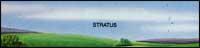
Stratus clouds
STRATUS clouds form as a continuous, horizontal layer a few hundred to 3,000 feet above the ground. These grayish clouds, sometimes ragged, sometimes smooth, usually result from the mingling of different layers of air at different temperatures. They occasionally produce light drizzle.
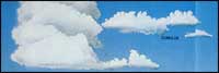
Cumulus clouds
CUMULUS clouds usually have flat bottoms and puffy, bulging, cauliflower-like tops. Their flat bottoms indicate the dew point level because all moisture below that point is invisible water vapor. Although they occur year-round, these beautiful clouds, with their constantly changing, fanciful shapes, are known as the fair-weather clouds of summer. As long as they stay separated, they do not produce rain; however, when they start to combine and build, they can create huge, towering thunderheads. Cumulus clouds form between 3,000 and 7,000 feet.
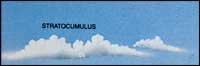
Stratocumulus clouds
STRATOCUMULUS clouds are, as their name indicates, cumulus clouds that are packed together in layers. They form slightly higher in the sky than regular stratus clouds. Their bottoms, which never are higher than 6,500 feet, have an uneven, rolling structure and display light and dark areas. They resemble dirty cotton balls and seldom produce moisture.
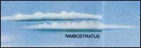
Nimbostratus clouds
NIMBOSTRATUS clouds are darker than stratus clouds and produce steady rain. They form in a thick, gray layer below 8,000 feet. Because of the amount of rain falling from it, the cloud usually is not visible from directly below.
Middle Clouds
The middle group of clouds forms between 6,000 and 20,000 feet and includes the altocumulus and altostratus clouds. These two cloud formations indicate counter-currents of moist air, and their appearance usually means that lower, more active clouds are nearby. Rain or snow may follow these formations.
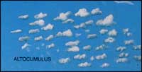
Altocumulus clouds
ALTOCUMULUS clouds are small, puffy ones that form high in the sky. They assume many different shapes, as is characteristic of all cumulus clouds. Often a formation of altocumulus clouds looks like a lot of unconnected little clouds piled together in a group. They also may form in ribbed rows, as wave-washed sand does on a beach.
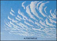
Altostratus clouds
ALTOSTRATUS clouds form in grayish fibrous sheets, or may present a smoother appearance. Occasionally they are so thin you can see a dim outline of the sun or moon through them; however, the sun does not shine through enough to cast a shadow.
High Clouds
The high clouds, which form between 20,000 and 40,000 feet, belong to the cirrus family and are all made of ice crystals. They include the cirrus, cirrostratus, and cirrocumulus clouds.
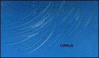
Cirrus clouds
CIRRUS clouds usually form in the highest portions of our atmosphere. They are thin, wispy, white plumes of ice crystals that have no shading and cast no shadows. One end, which curls or appears tufted, indicates the direction of the wind at that high altitude. This characteristic curl gives the clouds their Latin name and also gives them the common name mare�s tail. Because of their height, they appear to move quite slowly; however, they actually are racing along at speeds between 100 and 200 miles per hour. Their appearance in the sky may indicate an approaching storm.
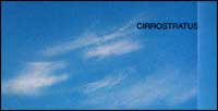
Cirrostratus clouds
CIRROSTRATUS clouds form as a transparent, whitish veil and may cover large portions of the sky. As light shines through this formation, its ice crystals create a halo or hazy ring around the sun or moon. Cirrostratus clouds usually indicate that rain or snow will follow within twenty-four hours.
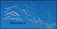
Cirrocumulus clouds
CIRROCUMULUS clouds form between 20,000 and 40,000 feet. They are small, fluffy balls that arrange themselves in rippled rows of clouds. They are in a constant state of change, obviously being disturbed by high-level turbulence, and they seldom last for very long. Some people call this formation a mackerel sky, and it usually means a warm front is on the way.
Low with Vertical Development
This special group contains only one cloud, the cumulonimbus. It begins near the ground in the low cloud area and extends upward through the middle area and into the high regions. It may extend as high as 70,000 feet.
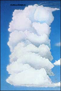
Cumulonimbus clouds
CUMULONIMBUS clouds are the massive, towering thunderheads so common in the summer. When the puffy, fair-weather cumulus clouds come together, they combine and begin to build upward. Violent up-and-down wind currents within the clouds develop, causing the top to boil higher and higher. When the cloud moves into the higher atmosphere an anvil-shaped top of ice crystals develops. This icy cirrus top stretches out flat and points the wind direction. Lightning, heavy rains, and often hail are created as the water clusters within the cloud are tossed up and down. This cloud may cover many square miles.
Weather forecasters study clouds because they know that certain types form before a storm. When you hear a weather forecaster say a warm front is on its way, watch the sky and you will see it develop. First, wispy cirrus clouds will appear in the west, perhaps accompanied by a few cirrocumulus. They will then merge into the cirrostratus clouds that create a halo around the sun or moon. They, in turn, will be hidden by a developing altostratus layer that blocks out the sun. The stage is now set for the appearance of the lower nimbostratus clouds with their steady rain. If cumulus and cumulonimbus develop within the nimbostratus, the steady rain will change to a heavy shower. As the storm moves on, it will leave stratocumulus clouds that soon disappear as fair weather returns.
Although you may never become an accurate weather forecaster, watching the clouds as they come and go in the sky should prove to be an interesting pastime.
Ilo
Hiller
1983 Clouds. Young
Naturalist. The
Louise Lindsey Merrick Texas
Environment Series, No.
6, pp. 134-137. Texas A&M
University Press, College
Station.