
Riverside Rally Loop Paddling Trail

Paddle the slow, scenic 7-mile loop trail along the Colorado River, where red cut banks, sandy shores, and live oaks set the stage for quiet wildlife sightings, from eagles and turtles to the occasional alligator, in the birding capital of Texas.
Trail Access
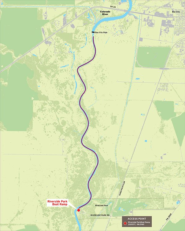
Riverside Park Boat Ramp
- Type:
- Access Point
- GPS Coordinates:
- 28.9217, -96.0160
Take Highway 60 South to FM 2668 and turn right. Approximately 2 miles from the round about you will see the Riverside Park sign and the Rio Colorado Golf Course sign. Turn right on Riverside Road. Proceed pass the golf course, over the railroad track and into the park. Stop at the Ranger Station to get a day-use pass.
Navigating the Trail
Trail Description
Trail Length: 7 miles total (3.5 miles to the dam and 3.5 miles back to the launch)
Float Time:
Total time for full 7-mile loop trail: 2-4 hours (depending on water levels, wind, and flow rate).
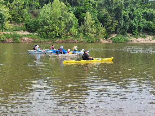
This scenic stretch of the Colorado River is a living river that changes with the seasons. Rainfall and river flow influence water levels, clarity, and current, shaping habitats for abundant birdlife in the birding capital of Texas, along with turtles, deer, and the occasional alligator. Paddle prepared, move quietly, and enjoy the river as nature intended.
Please Note: The LCRA Dam is located upriver. Follow all posted warning signs for your safety. Changing wind and river conditions can add a challenge at times. Paddle at your comfort level and enjoy the ride!
Site Information:
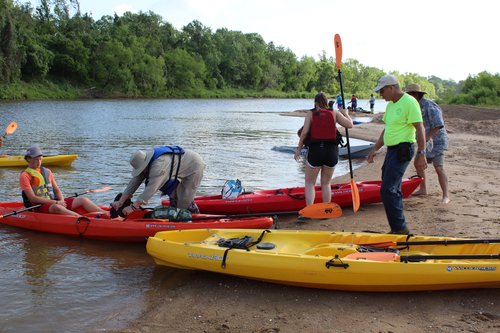
Day-use pass required - check in at Ranger Station.
Park entrance is locked and camping pass/permit is required after sunset for a fee.
Restrooms available at the trail put-in.
Leave no trace - use trash cans at take-out.
Private Property
Respect private property by not trespassing or littering and keeping noise levels down. This river is classified as navigable, which permits public use of the streambed and, if necessary, the banks to portage any hazard. Any other use of private river banks without permission of the landowner can be considered trespassing. Under Texas Penal Code (§30.05), criminal trespass occurs when one enters property after receiving notice not to enter. Notice includes verbal notice, a fence, sign(s), purple paint on posts or trees, or the visible presence of crops grown for human consumption.
Enjoy fishing, wildlife-watching and natural scenery on this paddling trail. Be sure to check the TPWD Paddling Events Calendar for regularly updated activities.
Trail Map
Things to Do and See

Fishing
A variety of sportfish can be found within this trail. We recommend paddlers planning to fish pack light-line and small lures such as jigs, plastic worms, and spinner baits for spin casting. Heavier tackle is needed for bottom fishing and larger game fish attracted to live bait. This stretch of the Colorado River offers great fishing for catfish, bass, alligator gar, gaspergoo, perch, flounder, redfish, and more. High tides may bring in saltwater species like sand trout and even blacktip or bull sharks. Small lures, live or dead bait work well. Please check our Weekly Fishing Reports for timely updates.
Wildlife and Ecology
This paddling trail is an approximately 7-mile round trip from the park to the Bay City Dam and back, following the gentle flow of the Colorado River. Along the way, shifting scenery reveals high banks and sandbars, colorful river-cut cliffs, and stretches shaded by live oaks and coastal-plain plants. The quiet pace invites wildlife sightings, from turtles, deer, raccoons, and turkeys to sandpipers, woodpeckers, vultures, caracaras, and even bald eagles, with the occasional alligator reminding you this is a truly wild river.
Rentals and Shuttles
Rent.fun
Services offered: kayak rentals, with lifejacket and paddle
832-686-3231
Website: Rent.fun Kayak in Bay City
Partnership
This trail was made possible through a partnership between Texas Parks and Wildlife Department, City of Bay City, and Visit Bay City.