Seadrift Paddling Trail
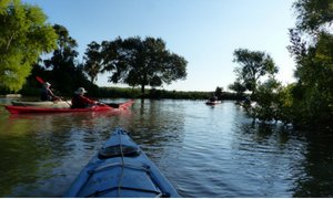
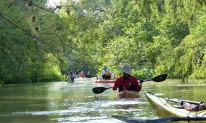
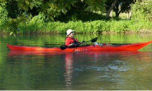
The Seadrift Paddling Trail consists of 20 miles of paddling trails accessed from four access points and offers river, lake, and even some expert level bay paddling opportunities.
Trail Access
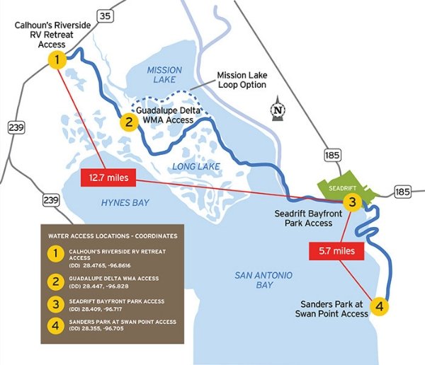
Calhoun's Riverside RV Retreat
- Type:
- Access Point
- GPS Coordinates:
- 28.4765, -96.8616
125 Haeber Lane, Tivoli, TX 77990 off Hwy 35; 361-550-7536
Directions: Haeber Lane is off SH35, immediately east of the River Bridge near Tivoli. Turn south; signage for the Retreat is a block ahead. The Retreat is privately owned and charges for launch and parking. Ample parking is available. The concrete ramp is for small boats and canoes/kayaks. A restroom and shower are available.
Guadalupe Delta Wildlife Management Area
- Type:
- Access Point
- GPS Coordinates:
- 28.4465, -96.8253
River Road Phone: (361) 552-6637; website: http://tpwd.texas.gov/huntwild/hunt/wma/find_a_wma/list/?id=37
Directions: River Road is off SH 35 just west of the River Bridge near Tivoli. Turn south. While the road is public, the property on both sides is private until you enter the GDWMA. Drive 3.4 miles south to the access point. The site is just inside the southern boundary of the GDWMA. A Limited Use Permit or an Annual Public Hunt Permit is required to use the site (available wherever fishing/hunting licenses are sold). The access site is primitive. Launch is from the river bank. Limited parking is available on road side only. No amenities are available. Camping is not permitted. All trash should be packed out. The site offers the best access for which to paddle the Mission Lake Loop since Traylors Cut is immediately downstream, minimizing the upstream paddling required to accomplish.
Seadrift Bayfront Park
- Type:
- Access Point
- GPS Coordinates:
- 28.4089, -96.7232
Pavilion: 699 W Bay Avenue, Seadrift TX 77983; Launch: 1201 W Bay Avenue; Phone: 361-785-2251
Directions: Seadrift is located on SH 185, south of SH 35. In Seadrift, turn south on Railroad Avenue, then merge into Main Street in several blocks. Turn right on Bay Avenue (at the Marina), and the access point is located at the west end of the Park at Bay Avenue and 12th Street, several blocks past the Pavilion. The access point is a concrete ramp. Ample parking is available. Public restrooms are available at the park pavilion.
Calhoun County Sanders Park at Swan Point
- Type:
- Access Point
- GPS Coordinates:
- 28.3899, -96.7078
Directions: Seadrift is located on SH 185, south of SH 35. To find Swan Point, from the east side of Seadrift, turn south on Dierlam Rd. Signage at key turns will direct you to "Boat Ramp." Turn left on Old Settlement Rd. Travel 1.1 miles and turn left on Swan Point Rd. Swan Point Rd. jogs left after 0.6 miles, then right after another 0.1 miles before arriving at a Y; stay right on Swan Point Rd. After 0.1 miles, turn right at T and continue on Swan Point Rd for 0.6 miles. Entrance to Swan Point boat ramp parking lot will be to the right. Site has a boat ramp and ample parking, but no other amenities. Sanders Park offers only picnic tables and access to San Antonio Bay.
Navigating the Trail
Follow this tips and guidelines, and be sure to view our safety information.
Trail Length: ~20 miles
Paddling Time: ~2-8 hours (as mapped, dependent on water levels, route, flow rate, and wind)
Trail Description
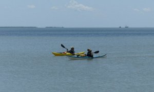
Please note: The stretch of trail across the bay is expert level paddling due to exposure to wind and waves. Please be sure to paddle at your skill level.
The Seadrift Paddling Trail consists of 20 miles of paddling trails accessed from four access points and several paddling options:
3.7 miles from Calhoun's RV Retreat to Guadalupe Delta WMA access at Traylor Cut
8.9 miles from Guadalupe Delta MWA to Seadrift Bayfront Park (Expert Level due to exposure to wind and waves)
3.6 miles loop from River mouth back to GDWMA launch, via Guadalupe Bay to Mission Lake to Traylor Cut back
3.3 miles Sanders Park to Seadrift Bayfront Park
This trail includes a scenic float down the last six miles of the Guadalupe River as it empties into Guadalupe Bay. From that point, expert paddlers can continue with a paddle across Guadalupe Bay and into San Antonio Bay to City Park. This route is the final leg in the famed Texas Water Safari, the toughest canoe race in the world. The area is also popular with waterfowl hunters in season.Trail Maps
Private Property
Respect private property by not trespassing or littering and keeping noise levels down. This river is classified as navigable, which permits public use of the streambed and, if necessary, the banks to portage any hazard. Any other use of private river banks without permission of the landowner can be considered trespassing. Under Texas Penal Code (§30.05), criminal trespass occurs when one enters property after receiving notice not to enter. Notice includes verbal notice, a fence, sign(s), purple paint on posts or trees, or the visible presence of crops grown for human consumption.
Things to Do and See
Enjoy fishing, wildlife-watching and natural scenery on this paddling trail. Be sure to check the TPWD Paddling Events Calendar for regularly updated activities.
Fishing
The area is known for producing red drum, spotted seatrout, black drum, and other popular fish. Spotted seatrout and large red drum are commonly caught all year long. Purchase a fishing map for details.
Wildlife and Ecology
The river delta supports a wide variety of shorebirds and migratory birds, including white pelicans, brown pelicans, herons and egrets, roseate spoonbills, ducks, sandhill cranes, grebes, loons, gulls and terns, willets, curlews, yellowlegs, godwits, dowitchers, plovers and peeps. The Atlantic bottlenose dolphin is spotted along the trail, and whooping cranes winter on the Aransas National Wildlife Refuge nearby, including the south end of Matagorda Island, so is occasionally seen foraging around the delta.
Rentals and Shuttles
Gerry's Kayak in Victoria
http://www.gerryskayaks.com/
(361) 935-3779
Partnership
This trail was made possible through a partnership between Texas Parks and Wildlife Department, City of Seadrift, Calhoun County, West Side Calhoun County Navigation District, Guadalupe Delta Wildlife Management Area-TPWD, Calhoun's Riverside RV Retreat, Guadalupe-Blanco River Authority, Coastal Bend Paddling Club, and San Antonio Bay Partnership.