South Bay Paddling Trail GPS Points
All coastal paddling trials are marked with signs for paddlers to follow. The signs are mounted on white vinyl poles with gold tape on them. The signs are white and have orange numbers that correspond to Global Positioning Satellite (GPS) latitude/longitude coordinates. Paddlers can either use a GPS unit to follow the trail or follow the signs by line-of-sight. Some paddling trails have multiple routes that are depicted by different colors on trail maps.
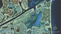
A color satellite map of South Bay Paddling Trail with GPS points identified is available as a PDF. This map is also available in a durable laminated version from select retailers. To get a list of these retailers contact Shoreline Publishing at 713-973-1627.
| ID # | Latitude | Longitude |
|---|---|---|
| 1 | 26° 02' 55.032" N | 97° 10' 53.292" W |
| 2 | 26° 02' 30.732" N | 97° 10' 48.540" W |
| 3 | 26° 02' 32.532" N | 97° 10' 36.120" W |
| 4 | 26° 02' 51.216" N | 97° 10' 17.796" W |
| 5 | 26° 02' 15.972" N | 97° 10' 06.672" W |
| 6 | 26° 01' 35.832" N | 97° 10' 16.896" W |
| 7 | 26° 01' 04.188" N | 97° 10' 13.728" W |
| 8 | 26° 00' 49.068" N | 97° 10' 04.224" W |
| 9 | 26° 00' 42.012" N | 97° 10' 31.332" W |
| 10 | 26° 01' 03.396" N | 97° 11' 15.504" W |
| 11 | 26° 00' 45.720" N | 97° 12' 03.492" W |
| 12 | 26° 01' 10.704" N | 97° 12' 15.552" W |
| 13 | 26° 01' 30.180" N | 97° 12' 19.980" W |
| 14 | 26° 01' 45.912" N | 97° 11' 56.688" W |
| 15 | 26° 02' 07.440" N | 97° 11' 38.616" W |
| 16 | 26° 02' 39.876" N | 97° 11' 06.360" W |