Central and South Texas Coastal Fringe Forest and Woodland
Geology:
This system occupies Holocene eolian sands of the South Texas Sand Sheet and sands of the Pleistocene Ingleside Barrier, which is mapped as Barrier Island and Beach Deposits of the Beaumont Formation.
Landform:
Generally level to gently rolling landscape. Some dunes to a height of more than 15 meters (50 feet) occur, adding significant relief to the regions. Low swales and round pothole wetlands typify low landscape positions, and significant drainage systems (in the form of streams) are generally lacking.
Soils:
Sands, particularly deep sands typify this system.
Parent Description:
This Quercus fusiformis (plateau live oak) dominated system occupies deep sands resulting from eolian deposits of Holocene and Pleistocene age. Ridge and swale topography characterizes these sites, with some large (up to 15 m tall) vegetated dunes present. In addition to forest and woodland, open stands grading into surrounding grasslands occur, as well as dense shrublands dominated (almost to the exclusion of other species) by running clones of Quercus fusiformis (plateau live oak). Northern expressions, occurring on Ingleside Barrier sands from Calhoun to Kleberg County, differ somewhat from southern expressions, occurring on the South Texas Sand Sheet from southern Kleberg, Kenedy, and northern Willacy counties west to Brooks County. These latitudinal expressions differ somewhat in composition, but the transition is subtle and the general character of the system remains relatively unchanged. The association CEGL007785 Quercus fusiformis – Prosopis glandulosa var. glandulosa / Malvaviscus arboreus var. drummondii Forest can be referred to the southern expression, while CEGL002117 Quercus fusiformis – Persea borbonia Forest represents the northern expression. The system occurs within a matrix of deep sand grasslands, but also as large patch forests and woodlands. Depending on the overstory canopy and the development of the shrub layer, the herbaceous cover may resemble the surrounding grasslands, at least in composition. Herbaceous species present may include Schizachyrium littorale (seacoast bluestem), Paspalum monostachyum (gulfdune paspalum), Paspalum plicatulum (brownseed paspalum), Andropogon gerardii (big bluestem), Sorghastrum nutans (Indiangrass), Elionurus tripsacoides (Pan American balsamscale), Trachypogon spicatus (crinkleawn), Acalypha radians (cardinal’s feather), Argythamnia mercurialina (tall wild-mercury), Chamaecrista flexuosa (partridge pea), Cnidoscolus texanus (Texas bull-nettle), Croton argyranthemus (silverleaf croton), Froelichia floridana (Florida snake-cotton), Galactia canescens (hoary milkpea), Eriogonum multiflorum (heartsepal wildbuckwheat), Rhynchosia americana (American snoutbean), Stillingia sylvatica (queen’s delight), Helianthemum georgianum (Georgia sunrose), Zornia bracteata (bracted zornia), and Thelesperma nuecense (Nueces greenthread). In northern expressions, Persea borbonia (redbay) is a conspicuous component of the subcanopy, and may reach the canopy, along with Quercus hemisphaerica (coastal laurel oak), Quercus marilandica (blackjack oak), and Celtis laevigata (sugar hackberry). A relatively continuous shrubby understory may be dominated by species such as Callicarpa americana (American beautyberry), Malvaviscus arboreus (Turk’s cap), and, in the north Ilex vomitoria (yaupon), or the shrub layer may not be well-developed. Other woody species in the understory may include Zanthoxylum hirsutum (tickle-tongue), Condalia hookeri (brasil), Ziziphus obtusifolia (lotebush), Zanthoxylum fagara (colima), Forestiera angustifolia (desert olive), Diospyros texana (Texas persimmon), and in the north, Vaccinium arboreum (farkleberry), Erythrina herbacea (coralbean), and Morella cerifera (wax-myrtle). The epiphytes Tillandsia recurvata (ballmoss) and Tillandsia usneoides (Spanish moss) are commonly encountered, with Tillandsia bailey (Bailey’s ballmoss) less commonly found, and only in the south. Vitis mustangensis (mustang grape) is a conspicuous woody vine throughout, while northern expressions may also contain Ampelopsis arborea (peppervine), Smilax bona-nox (saw greenbrier), and Toxicodendron radicans (poison ivy). The southern occurrences of this deep sand live oak woodland and forest have some woody and herbaceous species more characteristic of the south Texas plains. Most conspicuously, live oak woodland margins in the south have an open overstory co-dominated by Prosopis glandulosa (honey mesquite). Mesquite occurs, but to a less conspicuous extent, in the northern portions of the system. Pothole ponds and swales accumulate water through percolation from adjacent sands, and are characterized by the presence of numerous sedges including Cyperus spp. (flatsedges), Eleocharis spp. (spikerushes), Fimbristylis caroliniana (Carolina fimbry), Fuirena scirpoidea (southern umbrellasedge), Fuirena simplex (western umbrellasedge), Rhynchospora spp. (beaksedges), Schoenoplectus erectus ssp. raynalii (sharp-scale bulrush), Schoenoplectus saximontanus (Rocky Mountain bulrush), and Schoenoplectus pungens var. longispicatus (common threesquare). Other species commonly encountered in these wetlands include Andropogon glomeratus (bushy bluestem), Spartina patens (marshhay cordgrass), Echinodorus berteroi (common burhead), Hydrocotyle bonariensis (largeleaf pennywort), Juncus spp. (rushes), Mikania scandens (climbing hemp-weed), Nymphaea elegans (tropical royalblue waterlily), Phyla lanceolata (lanceleaf frogfruit), Sagittaria longiloba (longlobe arrowhead), and Typha domingensis (southern cattail).
Ecological Mapping Systems
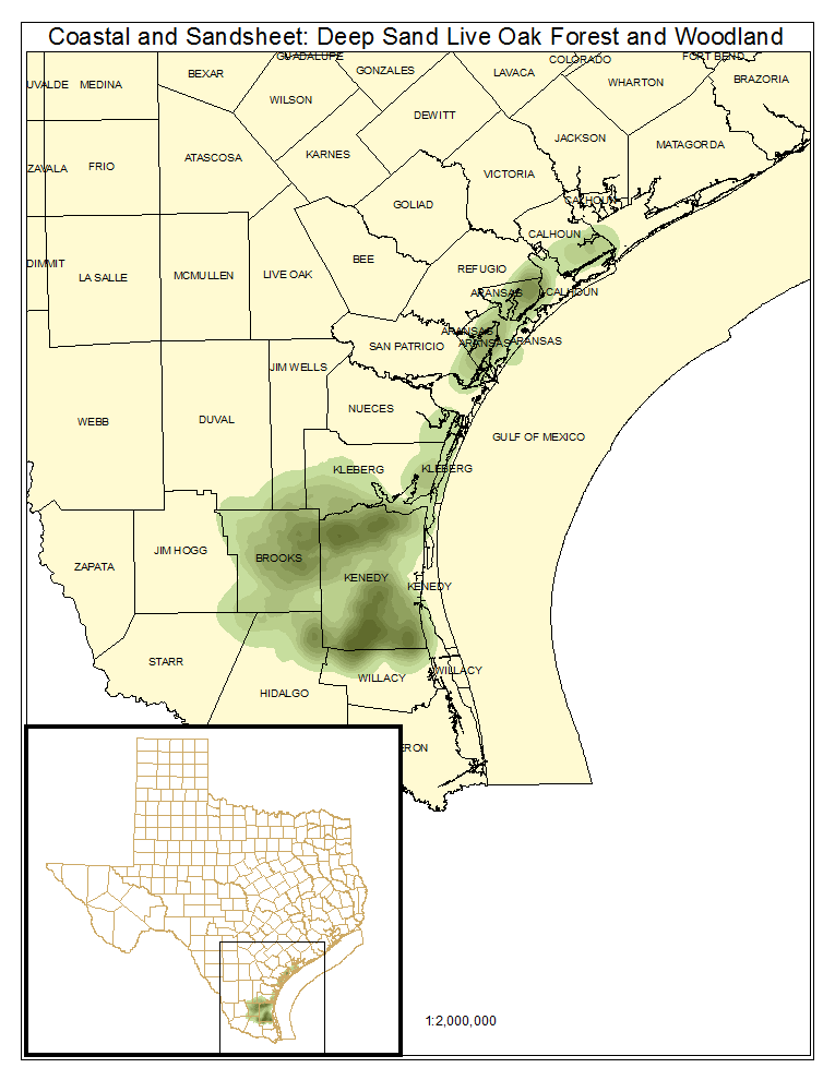
Coastal and Sandsheet: Deep Sand Live Oak Forest and Woodland
This broadleaf evergreen system is dominated by Quercus fusiformis (plateau live oak) in the overstory. This constitutes the typical woodland of the system and generally conforms to the system description.
Distribution Map

Photos

Coastal and Sandsheet: Deep Sand Live Oak - Mesquite Woodland
Quercus fusiformis (plateau live oak) and Prosopis glandulosa (honey mesquite) share dominance in the canopy of this type. It is best developed on the South Texas Sandsheet where it occurs on the margin of live oak forest and woodland. Shrubs typical of South Texas, such as Condalia hookeri (brasil), Zanthoxylum fagara (colima), Diospyros texana (Texas persimmon), and Ziziphus obtusifolia (lotebush) are also commonly encountered in this type.
Distribution Map

Public Land Occurrence
Coastal and Sandsheet: Deep Sand Live Oak Shrubland
This evergreen shrubland is dominated by low-stature Quercus fusiformis (plateau live oak) which sometimes forms extensive clones locally known as running live oak. These shrublands are often found in juxtaposition with live oak forest and woodland. Other shrub species, such as Morella cerifera (wax-myrtle), Ilex vomitoria (yaupon), and Baccharis spp. (baccharis), may be present.
Distribution Map

Photos

Coastal and Sandsheet: Deep Sand Live Oak Swale Marsh
Potholes and swales within the Deep Sand Live Oak Forest and Woodland accumulate moisture seasonally, and are typically dominated by various sedge species, including Cyperus spp. (flatsedges), Eleocharis spp. (spikerushes), Fimbristylis spp. (fimbrys), Fuirena spp. (umbrellasedges), Rhynchospora spp. (beaksedges), and Schoenoplectus spp. (bulrushes).
Distribution Map

Photos
