West Gulf Coastal Plain Sandhill Oak and Shortleaf Pine Forest and Woodland
Geology
Generally associated with Eocene sand formations such as Carrizo, Sparta, and Queen City sands. Also found on sands derived from the Pliocene Willis formation.
Landform
Generally found on high, convex landscape positions, such as hilltops and ridgetops.
Soils
Deep sands of soils such as the Betis, Darco, Letney, Tehran, Tonkawa, and other grossarenic or psammentic soils.
Parent Description
This system occupies deep sands on generally high, convex landforms, and often displays a relatively open overstory canopy. It may occur as pine dominated woodlands, with Pinus palustris (longleaf pine) dominating some sites within the range of this species, and Pinus echinata (shortleaf pine) dominating areas where Pinus palustris (longleaf pine) is absent. In the current landscape, Pinus taeda (loblolly pine) is a common and sometimes dominant pine species. Pines may co-dominate along with deciduous species, or the canopy may be dominated by oak and other deciduous species such as Quercus stellata (post oak), Quercus marilandica (blackjack oak), Quercus incana (bluejack oak), Quercus falcata (southern red oak), Quercus margarettae (sand post oak), and Carya texana (black hickory). Other deciduous trees present may include Sassafras albidum (sassafras), Liquidambar styraciflua (sweetgum), and Quercus nigra (water oak). The shrub stratum can be fairly well-developed, and includes shorter individuals of canopy species in addition to such species as Callicarpa americana (American beautyberry), Ilex vomitoria (yaupon), Vaccinium arboreum (farkleberry), Rhus aromatica (fragrant sumac), Asimina parviflora (dwarf pawpaw), Cornus florida (flowering dogwood), and Smilax bona-nox (saw greenbrier). The herbaceous layer may be quite well-developed or relatively patchy (with areas of bare sandy soil exposed). Commonly encountered species include Schizachyrium scoparium (little bluestem), Pteridium aquilinum (brackenfern), Aristida desmantha (curly threeawn), Ambrosia psilostachya (western ragweed), Cnidoscolus texanus (Texas bull-nettle), Rudbeckia hirta (blackeyed susan), Dichanthelium dichotomum (cypress panicgrass), Pityopsis graminifolia (narrowleaf silkgrass), Croton argyranthemus (silverleaf croton), Tragia urticifolia (nettleleaf noseburn), Froelichia floridana (Florida snake-cotton), Matelea cynanchoides (creeping milkvine), Opuntia humifusa (eastern pricklypear), Sporobolus junceus (pineywoods dropseed), Triplasis purpurea (purple sandgrass), Bulbostylis ciliatifolia (capillary hairsedge), Chamaecrista fasciculata (partridge pea), Berlandiera pumila (soft greeneyes), Commelina erecta var. angustifolia (narrowleaf dayflower), Stylisma pickeringii (bigpod bonamia), Tradescantia reverchonii (Reverchon spiderwort), Rhynchosia spp. (snoutbeans), Tephrosia spp. (tephrosia), and Yucca louisianensis (Gulf Coast yucca). Accurate mapping of this system proved problematic, because this system does not occur on all areas where the typical deep sands are mapped. Mapping only areas of high landscape position (the method used in this effort) tended to under-represent the system as it occurs on the landscape.
Ecological Mapping Systems
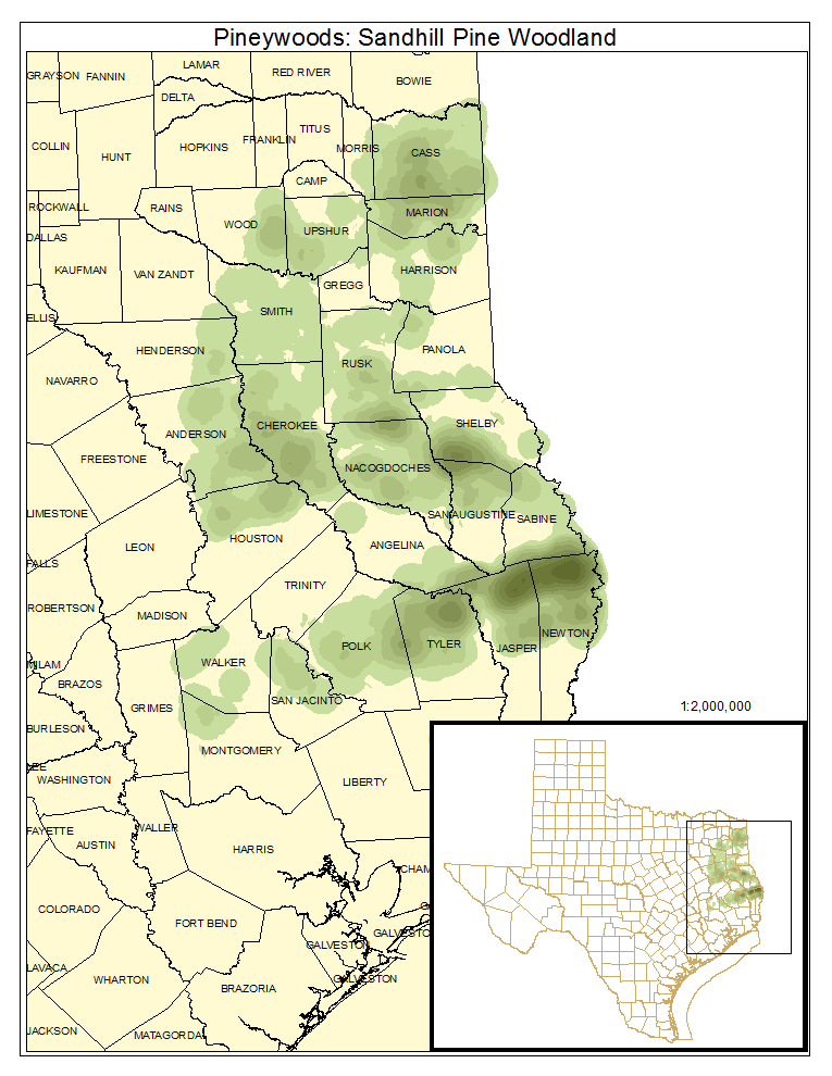
Pineywoods: Sandhill Pine Woodland
Occurrences dominated by pines, including Pinus palustris (longleaf pine) in the south, Pinus echinata (shortleaf pine), and Pinus taeda (loblolly pine). Pinus taeda (loblolly pine) has become more prevalent in current landscapes. About 46% of the system is mapped as this type.
Distribution Map

Photos

Pineywoods: Sandhill Oak / Pine Woodland
Occurrences having a mixed canopy, co-dominated by pines and usually oaks. This is a minor component of the system as mapped.
Distribution Map

Photos

Public Land Occurrence
Pineywoods: Sandhill Oak Woodland
Canopy usually dominated by oak species, but pine and other canopy species such as Carya texana (black hickory) and Liquidambar styraciflua (sweetgum) may also be present.
Distribution Map

Photos

Public Land Occurrence
Pineywoods: Sandhill Grassland or Shrubland
Occurrences where canopy cover is exceedingly sparse, giving rise to an open aspect, with shrub and herbaceous cover dominating. Graminoids such as Schizachyrium scoparium (little bluestem) dominate, but the diversity of forbs may be high. About 18% of the system is mapped as this vegetation type.
Distribution Map

Photos

Public Land Occurrence
- None.