Tamaulipan Mixed Deciduous Thornscrub
Geology
Well-represented on the Eocene Claiborne and Jackson Groups and the Pleistocene Beaumont Formation, but also found on various other formations.
Landform
On gently rolling to nearly level sites, sometime interdigitated with calcareous ridges and low lying drainages and bottomlands.
Soils
Clay, Clay Flat, and Clay Loam Ecological Sites are the typical soils for this system, though it may occur on a variety of other tight soils.
Parent Description
This shrubland is differentiated from Tamaulipan Savanna Grassland as it occupies tighter soils, as opposed to the sandier soils of the savanna grassland. The sites are often lower in the landscape compared to nearby savanna grassland or Tamaulipan Calcareous Shrubland, but would be considered uplands as they are distant from bottomland soils and drainages, and are not well-developed woodlands typical of the lowest landscape positions. To a large degree, all of these systems share numerous shrub species, but show subtle differences in relative dominance. However, this system generally occurs as a closed shrubland or low woodland, usually lacking a purely open herbaceous component. Soils are clays, clay loams, and clay flats and are often calcareous or alkaline to varying degrees. Some sites are highly saline, and these sites are occupied by Tamaulipan Saline Shrubland, but transitions between the systems may be subtle. Prosopis glandulosa (honey mesquite) is very often a conspicuous component of the canopy, sometimes reaching to 6 m in height. This canopy may be dense, but given the open nature of the canopy of individual Prosopis glandulosa (honey mesquite), significant solar radiation reaches the lower strata. Acacia farnesiana (huisache), Celtis ehrenbergiana (granjeno), Ebenopsis ebano (Texas ebony), and Celtis laevigata (sugar hackberry) may also be components of the canopy, but Prosopis glandulosa (honey mesquite) usually dominates. The overstory canopy may be open with only scattered emergent trees over a dense shrub layer at 1 to 3 m in height. Depending on land use history, the shrub understory may be limited to a few species such as Opuntia engelmannii var. lindheimeri (Lindheimer pricklypear), Ziziphus obtusifolia (lotebush), or Celtis ehrenbergiana (granjeno) on relatively recently cleared sites. On more mature sites, a diverse assemblage of species such as Acacia rigidula (blackbrush), Castela erecta (amargosa), Malpighia glabra (Barbados cherry), Opuntia engelmannii var. lindheimeri (Lindheimer pricklypear), Cylindropuntia leptocaulis (tasajillo), Ziziphus obtusifolia (lotebush), Celtis ehrenbergiana (granjeno), Lycium berlandieri (Berlandier wolfberry), Forestiera angustifolia (desert olive), Guaiacum angustifolium (guayacan), Diospyros texana (Texas persimmon), Amyris texana (Texas torchwood), Karwinskia humboldtiana (coyotillo), Havardia pallens (tenaza), Phaulothamnus spinescens (snake-eyes), Schaefferia cuneifolia (desert yaupon), Condalia hookeri (brasil), and Zanthoxylum fagara (colima) may occur. Leucophyllum frutescens (cenizo) and Acacia berlandieri (guajillo) may be present, but occur as scattered individuals as opposed to dominating the aspect of the community as they sometimes do on some shallow-soiled calcareous sites. However, like some shallow-soiled calcareous sites, Acacia rigidula (blackbrush) is the aspect dominant of the shrub layer. The herbaceous layer is usually fairly sparse. Currently, the herbaceous layer may actually be dense with the non-native grass Urochloa maxima (guineagrass). Other non-native species, such as Pennisetum ciliare (buffelgrass), Cynodon dactylon (bermudagrass), Bothriochloa ischaemum var. songarica (King Ranch bluestem), and Dichanthium annulatum (Kleberg bluestem), may also be present to dominant. Native grasses, such as Bothriochloa laguroides ssp. torreyana (silver bluestem), Trichloris spp. (false Rhodes grasses), and Pappophorum bicolor (pink pappusgrass), may be present.
Ecological Mapping Systems
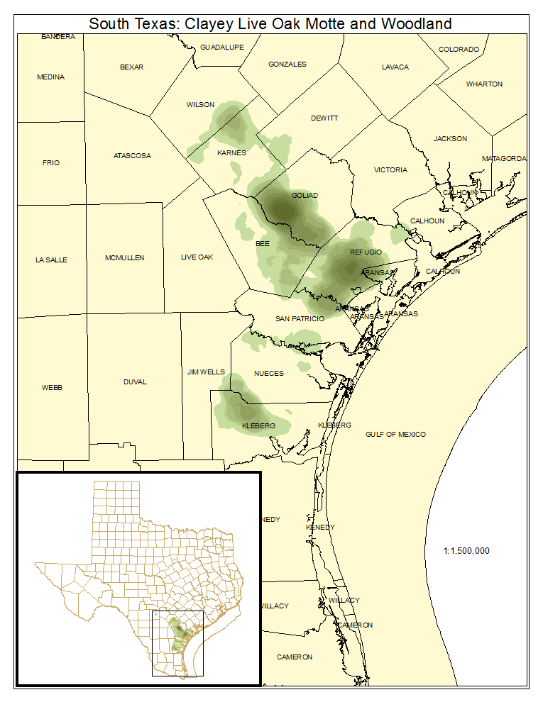
South Texas: Clayey Live Oak Motte and Woodland
Sites along the northern edge of the South Texas Plains on clayey substrates where Quercus fusiformis (plateau live oak) dominates the overstory. The understory is often dominated by numerous shrub species.
Distribution Map

Public Land Occurrence
- None.
South Texas: Clayey Mesquite Mixed Shrubland
Sites often with a sparse to dense overstory of Prosopis glandulosa (honey mesquite). Numerous shrub species occupy the understory, including Acacia farnesiana (huisache), Acacia rigidula (blackbrush), Opuntia engelmannii var. lindheimeri (Lindheimer pricklypear), and Celtis ehrenbergiana (granjeno).
Distribution Map

Photos

South Texas: Clayey Blackbrush Mixed Shrubland
Sites are typically dominated by a dense canopy of Acacia rigidula (blackbrush), but these sites may have numerous species in the canopy, including Prosopis glandulosa (honey mesquite), Celtis ehrenbergiana (granjeno), Condalia hookeri (brasil), and Opuntia engelmannii var. lindheimeri (Lindheimer pricklypear). These shrublands may be tall (to 2 or more meters in height) making them resemble dense woodlands.
Distribution Map

Photos

Public Land Occurrence
- Amistad National Recreation Area: US National Park Service
- Chaparral Wildlife Management Area: Texas Parks & Wildlife Department
- Falcon State Park: Texas Parks & Wildlife Department
- Garner State Park Area: Texas Parks & Wildlife Department
- James E. Daughtrey Wildlife Management Area: Texas Parks & Wildlife Department
- Laguna Atascosa National Wildlife Refuge: US Fish and Wildlife Service
- Lake Casa Blanca State Park: Texas Parks & Wildlife Department
- Lake Corpus Christi State Park: Texas Parks & Wildlife Department
- Lower Rio Grande Valley National Wildlife Refuge: US Fish and Wildlife