Tamaulipan Closed Depression Wetland
Geology
This system occurs over various geologic formations, from eolian sands, to the Lissie Formation, to the Goliad Formation. Occurrences are local and appear to be unrelated to underlying strata.
Landform
Local, internally draining basins or depressions.
Soils
Though this system may occur in a matrix of sandy substrate, the depressions that characterize it are typically lined by clays or clay loams. Lakebed Ecological Sites typify the occurrences.
Parent Description
This system occupies small, internally drained basins occurring over various substrates, but concentrated over the Lissie and Goliad Formations and the South Texas Sandsheet south of the Nueces River. They may be locally referred to as potholes, lagunas, lagunitas, ponds, or copitas. These basins are typically lined by clay or clay loam soils which tend to hinder drainage, resulting in moist conditions over extended periods. Characteristic woody species surrounding these basins include Acacia farnesiana (huisache), Parkinsonia aculeata (retama), and Prosopis glandulosa (honey mesquite) which make up a relatively sparse woodland canopy at a height of about 6 m. Celtis laevigata (sugar hackberry), Celtis ehrenbergiana (granjeno), and Ulmus crassifolia (cedar elm) may sometimes be present. Shrubs of these species, and other species such as Condalia hookeri (brasil), Lycium carolinianum (Carolina wolfberry), Heimia salicifolia (hachinal), and Sideroxylon celastrinum (la coma) may be present but typically do not occur as a dense shrub layer. Sesbania drummondii (rattlebox sesbania) is often encountered particularly in areas with reduced woodland canopy where water may stand for extended periods. The herbaceous layer winthin the woodland may commonly contain species such as Urochloa maxima (guineagrass), Chloracantha spinosa (spiny aster), Clematis drummondii (old man's beard), and Teucrium cubense (Cuban germander). Toward the center of the basin, woody cover is reduced or often absent and the herbaceous layer is often dominated by Cynodon dactylon (bermudagrass), but may also be characterized by a number of sedge species of the genera Eleocharis (including species such as Eleocharis quadrangulata (squarestem spikesedge) and Eleocharis palustris (bigstem spikesedge)) and Cyperus (including species such as Cyperus articulatus (jointed umbrellasedge), Cyperus acuminatus (taperleaf flatsedge), and Cyperus squarrosus (bearded umbrellasedge)), as well as Schoenoplectiella saximontana (annual bulrush). Numerous other species may be present, including Paspalum distichum (knotgrass), Setaria parviflora (knotroot bristlegrass), Eragrostis spicata (spike lovegrass), Calyptocarpus vialis (straggler daisy), Eryngium nasturtiifolium (hierba del sapo), Eclipta prostrata (yerba de tajo), Phyla nodiflora (common frog-fruit), Soliva mutisii (Mutis' burrweed), Rorippa teres (tansyleaf yellowcress), Lindernia dubia (moistbank pimpernel), Rotala ramosior (tooth-cup), Bacopa rotundifolia (disc waterhyssop), Heteranthera limosa (blue mudplantain), Echinodorus berteroi (common burhead), Echinodorus tenellus (mudbabies), Sagittaria longiloba (longlobe arrowhead), Nymphaea elegans (tropical royalblue waterlily), Marsilea macropoda (bigfoot water-clover), Lemna spp. (duckweed) and Wolffia spp. (watermeal).
Ecological Mapping Systems
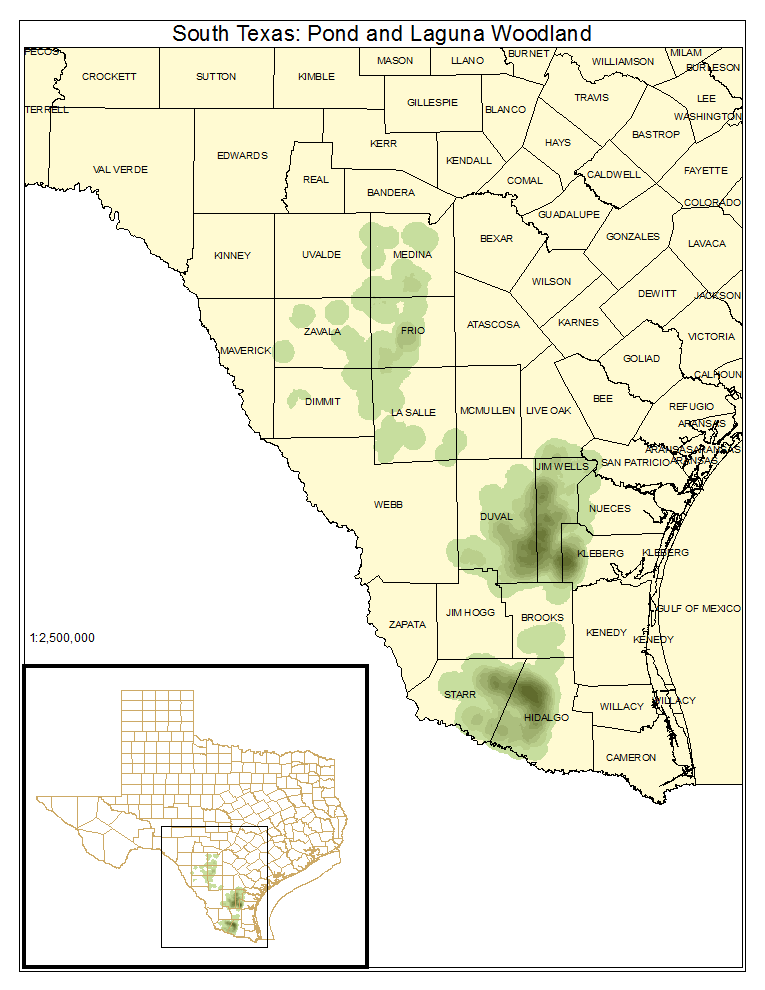
South Texas: Pond and Laguna Woodland
Woodlands to a height of 6 m, or slightly higher, usually dominated by Acacia farnesiana (huisache) and Parkinsonia aculeata (retama) surrounding internally draining basins.
Distribution Map

Photos

Public Land Occurrence
- None.
South Texas: Pond and Laguna Shrubland
Shrublands surrounding internally draining basins which are dominated by low stature Acacia farnesiana (husiache), Parkinsonia aculeata (retama), and species such as Lycium carolinianum (Carolina wolfberry), Celtis ehrenbergiana (granjeno), and Sesbania drummondii (rattlebox sesbania).
Distribution Map

Public Land Occurrence
- None.
South Texas: Pondshore Herbaceous Vegetation
Area directly surrounding the basin transitioning from species such as Cynodon dactylon (bermudagrass) and Calyptocarpus vialis (straggler daisy) at the drier edges of the basin to floating species such as Lemna spp. (duckweed) and Nymphaea elegans (tropical royalblue waterlily) in basins that hold water for extended periods.
Distribution Map

Photos

Public Land Occurrence
- None.