Tamaulipan Ramadero
Geology
Widespread system on various geologic strata.
Landform
Upland drainages in various landscapes. Drainages are extremely flashy from runoff from surrounding landscape. These sites are infrequently flooded during local rainfall events, but because they accumulate runoff, they tend to be slightly more mesic in this otherwise xeric landscape.
Soils
Various upland soils (not Bottomland ecological site types), sometimes mapped specifically as Ramadero Ecological Site.
Parent Description
These woodlands are found along drainages (locally known as ramaderos) that are extremely flashy and are infrequently and briefly flooded during local rain events. The soils are typically clay loams or sandy clay loams, and moisture accumulation due to their topographic position promotes the development of a closed canopy (relative to the surrounding landscape) from 5 to 10 m in height. The overstory canopy is typically dominated by species such as Prosopis glandulosa (honey mesquite), Acacia farnesiana (huisache), Celtis ehrenbergiana (granjeno), and/or Parkinsonia aculeata (retama). Celtis laevigata (sugar hackberry) and/or Ebenopsis ebano (Texas ebony) may also be present in the canopy. Some sites have a relatively open subcanopy, but more commonly the shrub layer is thick, sometimes impenetrable, and varies in height from 1 to 5 m. Species commonly encountered in the shrub layer include Aloysia gratissima (whitebrush), Phaulothamnus spinescens (snake-eyes), Celtis ehrenbergiana (granjeno), Condalia hookeri (brasil), Forestiera angustifolia (desert olive), Diospyros texana (Texas persimmon), Ziziphus obtusifolia (lotebush), Koeberlinia spinosa (allthorn), Malpighia glabra (Barbados cherry), Zanthoxylum fagara (colima), Opuntia engelmannii var. lindheimeri (Lindheimer pricklypear), Guaiacum angustifolium (guayacan), Colubrina texensis (Texas hogplum), and Amyris texana (Texas torchwood). Ground cover can be sparse, or in more open stands, may have a fairly continuous grassy cover. Species encountered in the herbaceous layer include Clematis drummondii (old man's beard), Parietaria pensylvanica (cucumberweed), Salvia coccinea (tropical sage), Calyptocarpus vialis (straggler daisy), Rivina humilis (pigeonberry), Malvastrum americanum (Rio Grande false-mallow), Ruellia spp. (wild petunia), and Verbesina microptera (southern frostweed). Grasses include Trichloris pluriflora (multiflower false Rhodes grass), Bothriochloa barbinodis (cane bluestem), Bouteloua curtipendula (sideoats grama), Setaria scheelei (southwestern bristlegrass), Setaria macrostachya (bigstem bristlegrass), Setaria leucopila (plains bristlegrass), Chloris cucullata (hooded windmillgrass), Digitaria californica (Arizona cottontop), Pappophorum bicolor (pink pappusgrass), Bouteloua trifida (red grama), Bouteloua dactyloides (buffalograss), and Hilaria belangeri (curlymesquite). The introduced grasses Pennisetum ciliare (buffelgrass), Urochloa maxima (guineagrass), and Cynodon dactylon (bermudagrass) often dominate these sites, sometimes to the near exclusion of other herbaceous cover. This system may merge downstream with the Tamaulipan Floodplain system.
Ecological Mapping Systems
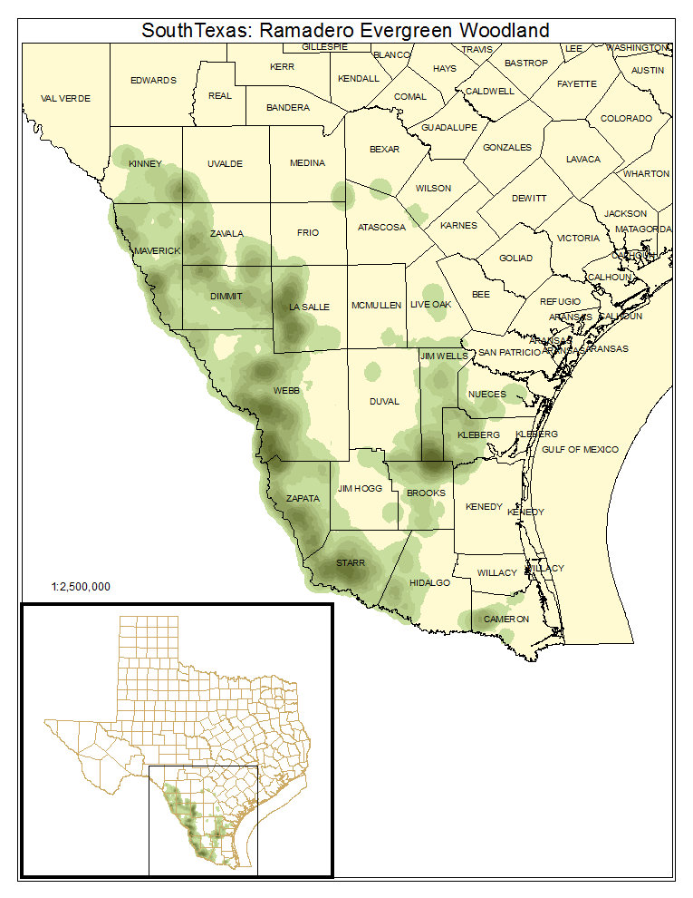
South Texas: Ramadero Evergreen Woodland
Less than three percent of this system as it is mapped is occupied by this type which has a significant broadleaf evergreen component, often Ebenopsis ebano (Texas ebony) but sometimes Quercus fusiformis (plateau live oak) in the northern part of the South Texas Plains.
Distribution Map

Photos

South Texas: Ramadero Woodland
Woodlands 5 to 10 m in height, with a canopy typically dominated or co-dominated by Prosopis glandulosa (honey mesquite), Acacia farnesiana (huisache), Celtis ehrenbergiana (granjeno), Parkinsonia aculeata (retama), and/or Celtis laevigata (sugar hackberry). The shrub layer is often well-developed.
Distribution Map

Photos

South Texas: Ramadero Dense Shrubland
Dense shrublands occupying drainages, with canopy cover reaching near 100% from 0.5 to 3.0 m in height. These shrublands may be dominated by numerous species. Aloysia gratissima (whitebrush) may sometimes form dense stands in these sites.
Distribution Map

Photos

Public Land Occurrence
- Chaparral Wildlife Management Area: Texas Parks & Wildlife Department
- Falcon State Park: Texas Parks & Wildlife Department
- Laguna Atascosa National Wildlife Refuge: US Fish and Wildlife Service
- Lake Casa Blanca State Park: Texas Parks & Wildlife Department
- Lower Rio Grande Valley National Wildlife Refuge: US Fish and Wildlife
South Texas: Ramadero Shrubland
Typical shrublands along drainages making up the majority of the system. These sites are dominated by a suite of shrub species including Prosopis glandulosa (honey mesquite), Acacia farnesiana (huisache), Celtis ehrenbergiana (granjeno), Diospyros texana (Texas persimmon), and Ziziphus obtusifolia (lotebush).
Distribution Map

Photos

Public Land Occurrence
- Bentsen-Rio Grande Valley State Park: Texas Parks & Wildlife Department
- Chaparral Wildlife Management Area: Texas Parks & Wildlife Department
- Falcon State Park: Texas Parks & Wildlife Department
- Lake Casa Blanca State Park: Texas Parks & Wildlife Department
- Lower Rio Grande Valley National Wildlife Refuge: US Fish and Wildlife