West Gulf Coastal Plain Pine - Hardwood Flatwoods
Geology
High Pleistocene terraces, mapped in the northern portion of East Texas as Quaternary Fluviatile Terrace (or Tile) Deposits.
Landform
Very gently undulating to flat surfaces, with local topographic relief provided by ridges and swales.
Soils
Soils tend to be fine-textured. They typically have a somewhat impermeable subsurface horizon, which leads to a perched water table. Saturation results from local rainfall run- on, and alternates with seasonal drying, leading to a xerohydric hydroperiod.
Parent Description
This system primarily occurs within the Flatwoods EPA Level IV ecoregion, but is also found associated with the Pleistocene Fluvial Terraces ecoregion in the northern portion of East Texas. This woodland or forest system is often dominated by more mesic species on interior ridges, including Pinus taeda (loblolly pine), Pinus echinata (shortleaf pine), Pinus elliottii (slash pine), Quercus stellata (post oak), Quercus alba (white oak), Quercus falcata (southern red oak), and Carya texana (black hickory). Within the range of Pinus palustris (longleaf pine), occurrences that represent West Gulf Coastal Plain Wet Longleaf Pine Savanna and Flatwoods may be mapped as this system. On the somewhat wetter sites of the swales, species such as Quercus nigra (water oak), Quercus phellos (willow oak), Quercus laurifolia (laurel oak), Nyssa sylvatica (blackgum), Liquidambar styraciflua (sweetgum), and Fraxinus pennsylvanica (green ash) may be dominant. Sites that are even wetter would likely be mapped as West Gulf Coastal Plain Nonriverine Wet Hardwood Flatwoods. Triadica sebifera (Chinese tallow) may invade this system. Mid-story species that may be encountered include Acer rubrum (red maple), Ilex opaca (American holly), Ulmus alata (winged elm), and small members of the overstory. Morella cerifera (wax-myrtle), Ilex decidua (possumhaw), and Ilex vomitoria (yaupon) are commonly encountered shrubs. Herbaceous cover is generally sparse, with species such as Chasmanthium spp. (woodoats), Andropogon glomeratus (bushy bluestem), and Gelsemium sempervirens (Carolina jessamine). Sites dominated by Pinus taeda (loblolly pine) or Pinus elliottii (slash pine) may often represent plantations or managed forests.
Ecological Mapping Systems
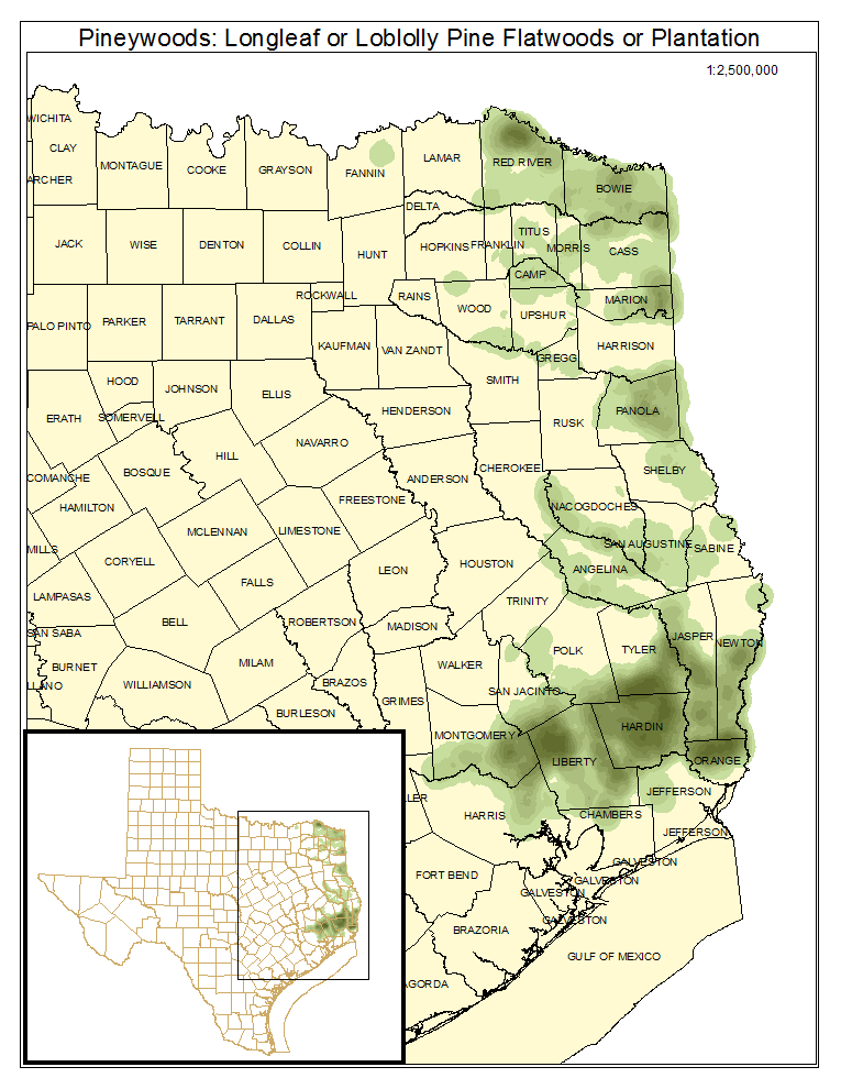
Pineywoods: Longleaf or Loblolly Pine Flatwoods or Plantation
This mapped type on flatwoods sites are dominated by Pinus taeda (loblolly pine), Pinus elliottii (slash pine), and to a lesser extent, Pinus echinata (shortleaf pine). Within the range of Pinus palustris (longleaf pine), this type may represent occurrence of West Gulf Coastal Plain Wet Longleaf Pine Savanna and Flatwoods.
Distribution Map

Photos

Public Land Occurrence
- Angelina National Forest: US Forest Service
- Big Thicket National Preserve: US National Park Service
- Caddo National Grasslands Wildlife Management Area: Texas Parks & Wildlife Department
- Lake Houston Wilderness Park: City of Houston
- Martin Dies, Jr. State Park: Texas Parks & Wildlife Department
- Sabine National Forest: USDA Forest Service
- Sam Houston National Forest Wildlife Management Area: Texas Parks & Wildlife Department
- Wright Patman Lake: US Army Corps of Engineers
Pineywoods: Longleaf or Loblolly Pine / Hardwood Flatwoods or Plantation
This mapped type has a mix of Pinus spp. (pines) and hardwoods in the canopy. This is a fairly minor component of the system.
Distribution Map

Photos

Public Land Occurrence
- Angelina National Forest: US Forest Service
- Big Thicket National Preserve: US National Park Service
- Lake Houston Wilderness Park: City of Houston
- Martin Dies, Jr. State Park: Texas Parks & Wildlife Department
- Sabine National Forest: USDA Forest Service
- Sam Houston National Forest Wildlife Management Area: Texas Parks & Wildlife Department
- Wright Patman Lake: US Army Corps of Engineers
Pineywoods: Hardwood Flatwoods
This mapped type lacks significant evergreen canopy.
Distribution Map

Photos

Public Land Occurrence
- Angelina National Forest: US Forest Service
- Big Thicket National Preserve: US National Park Service
- Caddo National Grasslands Wildlife Management Area: Texas Parks & Wildlife Department
- Lake Houston Wilderness Park: City of Houston
- Roy E. Larsen Sandyland Sanctuary: The Nature Conservancy
- Sam Houston National Forest Wildlife Management Area: Texas Parks & Wildlife Department
- Wright Patman Lake: US Army Corps of Engineers