Western Great Plains Floodplain
Geology
This system generally occurs on Quaternary Alluvium.
Landform
Valley floors of large rivers and perennial streams. This system tends to occupy broad valley bottoms with deep alluvial deposits. In Phase 1, this system is found within the Clear Fork of the Middle Brazos watersheds.
Soils
This system occurs on Loamy Bottomland, Clayey Bottomland, and Draw ecoclasses.
Parent Description
This system is characteristic of valley floors of large rivers and perennial streams where significant alluvial deposition occurs. Broad alluvial deposits commonly occur and are generally mapped as bottomland soils. This system can be expressed in numerous cover types including forests, woodlands, shrublands, and herbaceous vegetation (where marshes may develop in the floodplain soils, or mesic prairie dominated by Andropogon gerardii (big bluestem) and Panicum virgatum (switchgrass) may be conspicuous). Populus deltoides (eastern cottonwood), Sapindus saponaria var. drummondii (western soapberry), Prosopis glandulosa (mesquite), Salix nigra (black willow), Ulmus americana (American elm), and/or Celtis laevigata var. reticulata (netleaf hackberry) may be important components of forests or woodlands of this system. Juniperus ashei (Ashe juniper), Juniperus pinchotii (redberry juniper), and/or Quercus fusiformis (plateau live oak) may be present to dominant, but such evergreen dominated sites generally occur on the eastern edge of the range of this system. As this is the eastern extent of the overall distribution of the system, some species occur in the system at the western edge of their range, and may not be represented further west within the range of the system. Such species include Quercus fusiformis (plateau live oak) and Ulmus americana (American elm). Shrublands may also have Prosopis glandulosa (mesquite) and Salix nigra (black willow) as important components. Some shrublands in this system, especially those on more saline sites, may be dominated by the non-native Tamarix spp. (saltcedar). Woodlands may sometimes be dominated by the non-natives Tamarix spp. (saltcedar), Ulmus pumila (Siberian elm), or Elaeagnus angustifolia (Russian olive). Herbaceous vegetation may include marshes occupying floodplain sites, with species such as Schoenoplectus spp. (bulrush) and/or Typha spp. (cattails). Some sites may be dominated by tallgrass species such as Andropogon gerardii (big bluestem) and Panicum virgatum (switchgrass). More typically, sites lacking significant woody cover may be dominated by Pleuraphis mutica (tobosa), Nassella leucotricha (Texas wintergrass), and Panicum obtusum (vine mesquite). Non-native graminoids are also commonly encountered and include Cynodon dactylon (bermudagrass), Sorghum halepense (Johnsongrass), Bromus arvensis (Japanese brome), and Bothriochloa ischaemum var. songarica (King Ranch bluestem). Shrublands are commonly dominated by Prosopis glandulosa (honey mesquite) and are mapped as Western Great Plains Mesquite Woodland and Shrubland (CES303.668).
Ecological Mapping Systems
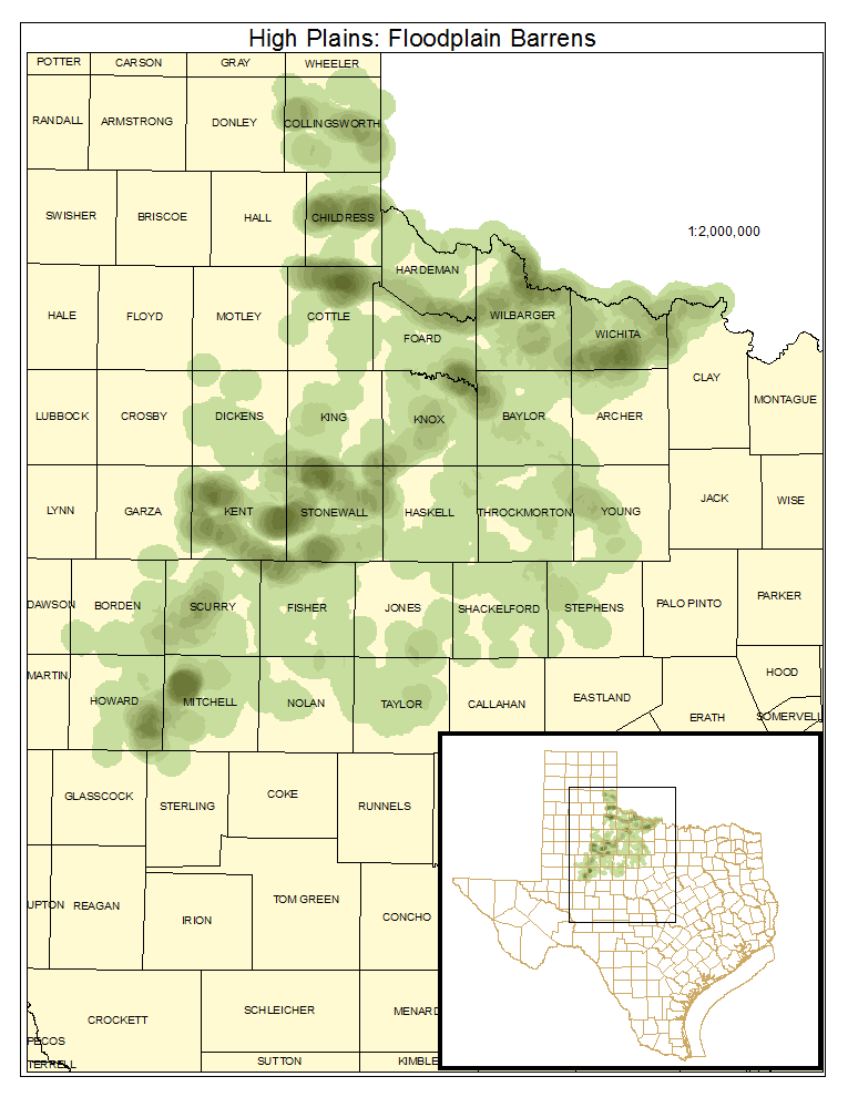
High Plains: Floodplain Barrens
Areas within the floodplain that lack significant vegetative cover. These occurrences represent mud, sand, and gravel bars, but may also be disturbed sites.
Distribution Map

High Plains: Floodplain Juniper Forest
Forest or woodland as described for the system, but with Juniperus ashei (Ashe juniper) or Juniperus pinchotii (redberry juniper) as the overstory dominant. This is a very minor component of the system.
Distribution Map

Photos

Public Land Occurrence
- None.
High Plains: Floodplain Live Oak Forest
Forest or woodland as described for system, but with Quercus fusiformis (plateau live oak) as the overstory dominant. This is a minor component of the system.
Distribution Map

Photos

Public Land Occurrence
- None.
High Plains: Floodplain Hardwood / Juniper Forest
Forest or woodland as described for system. Overstory is dominated by a mix of evergreen species (such as Juniperus ashei (Ashe juniper), Juniperus pinchotii (redberry juniper), and/or Quercus fusiformis (plateau live oak)) and deciduous species.
Distribution Map

Photos

Public Land Occurrence
- None.
High Plains: Floodplain Hardwood Forest
Forest or woodland as described for system with a deciduous overstory canopy.
Distribution Map

Photos

High Plains: Floodplain Juniper Shrubland
Shrubland on floodplain dominated by Juniperus ashei (Ashe juniper) or Juniperus pinchotii (redberry juniper). This is a very minor component of the system, at least in Phase 1.
Distribution Map

Photos

Public Land Occurrence
- None.
High Plains: Floodplain Deciduous Shrubland
Shrubland on floodplain, dominated by deciduous shrub species such as Prosopis glandulosa (mesquite), Salix nigra (black willow), Sapindus saponaria var. drummondii (western soapberry), Ziziphus obtusifolia (lotebush) and/or Celtis laevigata (sugar hackberry). Tamarix spp. (saltcedar) may also be present to dominant in the shrub layer.
Distribution Map

Photos

Public Land Occurrence
- None.
High Plains: Floodplain Herbaceous Vegetation
This herbaceous vegetation may be represented by marshes on floodplains, where Schoenoplectus spp. (bulrush), Eleocharis spp. (spikerush), and/or Typha spp. (cattail) dominate. Patches of tallgrass prairie that may be dominated by species such as Andropogon gerardii (big bluestem) or Panicum virgatum (switchgrass) may also be mapped as this vegetation type.
Distribution Map

Photos
