Conservation Committee
Wednesday, 9:00 a.m.
May 23, 2012
Texas Parks and Wildlife Department
Commission Hearing Room
4200 Smith School Road, Austin, TX 78744
Chairman T. Dan Friedkin, Committee Chair
Scott Boruff, Committee Liaison
Approval of Previous Meeting Minutes
- Update on TPWD Progress in Implementing the TPWD Land and Water Resources Conservation and Recreation Plan
- Migratory Game Bird Proclamation Update
- Lesser Prairie Chicken
- Bastrop State Park
- Internal Affairs Report
- Chronic Wasting Disease Response Plan and Proposed Regulatory Response, including Rulemaking
- Acceptance of Land Donation — Harris County — 2.5 Acres Adjacent to Sheldon Lake State Park (Action Item No. 6)
Staff: Corky Kuhlmann - Acceptance of Land Donation — Aransas County — Approximately 80 Acres at the Big Tree area at Goose Island State Park (Action Item No. 8)
Staff: Ted Hollingsworth - Request for Easement — Harris County — Hydrocarbon Pipelines at San Jacinto Battleground State Historic Site (Action Item No. 9)
Staff: Ted Hollingsworth - Definition of Existing Easement — Harris County — Pipeline Corridor at San Jacinto Battleground State Historic Site — Request Permission to begin the Public Notice and Input Process
Staff: Ted Hollingsworth - Land Acquisition — Stephens County — 640 Acres at Palo Pinto Mountains State Park — Request Permission to begin the Public Notice and Input Process
Staff: Ted Hollingsworth - Lease Termination — Jackson County — Lake Texana State Park — Request Permission to begin the Public Notice and Input Process
Staff: Ted Hollingsworth - Request for Surface Use Agreement — Dimmit and LaSalle Counties — Oil and Gas Development on the Chaparral Wildlife Management Area (WMA) (Executive Session Only)
Staff: Ted Hollingsworth - Texas Commission on Environmental Quality — Contested Case Rules (Executive Session Only)
Staff: Ann Bright - Personnel Matters — Selection of New Internal Auditor (Executive Session)
(Action Item No. 2)
Staff: Carter Smith
Committee Agenda Item No. 1
Presenter: Carter Smith
Conservation Committee
Update on TPWD Progress in Implementing the
TPWD Land and Water Resources Conservation and Recreation Plan
May 23, 2012
I. Executive Summary: Executive Director Carter Smith will briefly update the Commission on the status of the agency’s efforts to implement the Land and Water Resources Conservation and Recreation Plan (the “Plan”).
II. Discussion: In 2001, the 77th Texas Legislature directed that the Texas Parks and Wildlife Department (TPWD) develop a Land and Water Resources Conservation and Recreation Plan (Tex. Park & Wild. Code §11.104). In 2002, the Texas Parks and Wildlife Commission (the Commission) adopted the first Plan. A revised Plan was adopted by the Commission in January 2005. In November 2009, the Commission approved a new Plan effective January 1, 2010. The 2010 Plan is available on the TPWD web site. Executive Director Carter Smith will update the Conservation Committee on TPWD’s recent progress in achieving the Plan’s goals, objectives and deliverables.
The Plan consists of the following four goals:
- Practice, Encourage and Enable Science-based Stewardship of Natural and Cultural Resources
- Increase Access To and Participation In the Outdoors
- Educate, Inform and Engage Texas Citizens in Support of Conservation and Recreation
- Employ Efficient, Sustainable and Sound Business Practices
Committee Agenda Item No. 5
Presenter: Ted Hollingsworth
Conservation Committee
Definition of Existing Easement–Harris County
Pipeline Corridor at San Jacinto Battleground State Historic Site
May 23, 2012
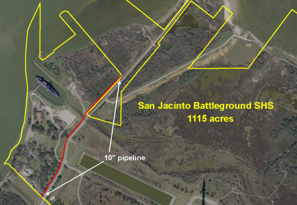
I. Executive Summary: Surveys associated with a request from Chevron Phillips Chemical Company LP (Chevron) to expand an existing pipeline corridor at San Jacinto Battleground State Historic Site (San Jacinto) revealed that a 10” pipeline installed in 1969 lies partially outside the easement granted in 1969.
II. Discussion: San Jacinto, located 20 miles east of downtown Houston, consists of just over 1,000 acres, centered on the campsites and primary field of battle where a volunteer Texan army defeated a numerically superior Mexican army to wrest independence from Mexico on April 21, 1836.
Today San Jacinto is located in the heart of the petrochemical refining complexes of Baytown, Deer Park, Pasadena and La Porte. As a result, numerous pipelines located in several corridors have crossed the site for many decades. Staff has worked diligently over the years to confine these corridors to small areas and minimize impacts to resources, operations and aesthetics.
Chevron approached TPWD in 2011 with a plan to add two (2) pipelines to its existing corridor through the park. Knowing that a reach of the existing corridor was confined to the State Highway right-of-way (ROW), and that the ROW had never been surveyed, Chevron and its consultants worked closely with TPWD staff to locate the existing corridor and San Jacinto boundaries. In so doing, it was discovered that a 10” pipeline installed in 1969 wanders out of the ROW and into the park. Staff proposes to issue an easement covering the existing pipeline. Chevron has agreed to pay easement fees from the current TPWD rate schedule and to seek a Surface Use Agreement from TPWD any time future operations require work within the easement in the park. Staff requests permission to begin the public notice and input process.
Committee Agenda Item No. 5
Exhibit A
Location Map Showing the Location of San Jacinto Battleground in Harris County
Committee Agenda Item No. 5
Exhibit B
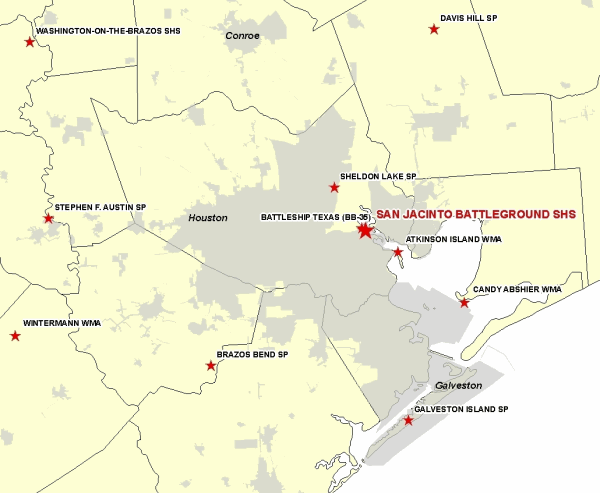
Vicinity Map Showing San Jacinto Battleground, 20 Miles East of Houston
Committee Agenda Item No. 5
Exhibit C
Site Map Showing Location of Pipeline Requiring Easement Definition
Committee Agenda Item No. 6
Presenter: Ted Hollingsworth
Conservation Committee
Land Acquisition-Stephens County
640 Acres at Palo Pinto Mountains State Park
May 23, 2012
I. Executive Summary: Staff has negotiated an Option to Buy 640 acres of land adjacent to the new Palo Pinto Mountains State Park.
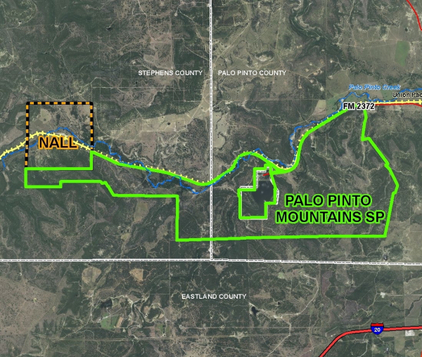
II. Discussion: In 2011, Texas Parks and Wildlife Department (TPWD) used proceeds from the sale of Eagle Mountain Lake State Park to acquire 3,333 acres of land in southwest Palo Pinto and southeast Stephens counties for the purpose of establishing a new state park in the crosstimbers region west of Fort Worth. Budget limitations kept TPWD from acquiring the Nall Ranch at the time, but due to its configuration and natural features, it has remained high on TPWD’s list of priorities for acquisition. Having sold the Fortress Cliffs Ranch at Palo Duro Canyon State Park, staff recommends conversion of land sale proceeds, which include a federal interest, for the acquisition of the Nall Ranch, and has negotiated an Option to Buy that contemplates a closing in September.
Staff requests permission to begin the public notice and input process.
Attachments-3
Committee Agenda Item No. 6
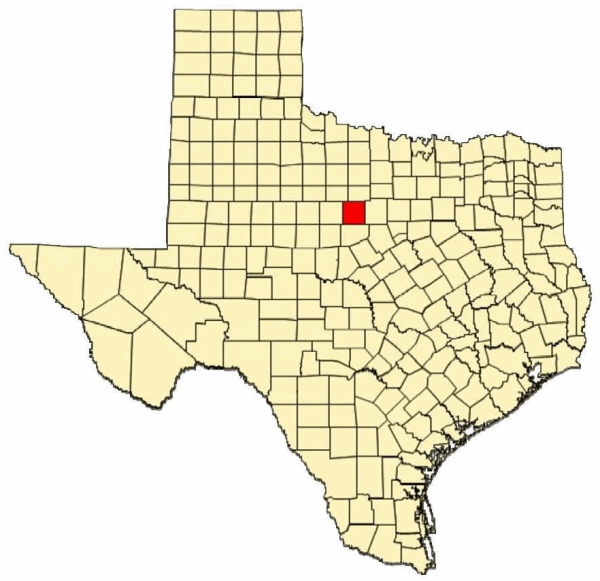
Exhibit A
Location of Proposed Acquisition in Stephens County, Palo Pinto Mountains State Park
Committee Agenda Item No. 6
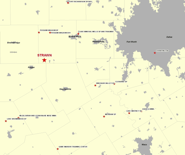
Exhibit B
Vicinity Map for Palo Pinto Mountains State Park at Strawn
Committee Agenda Item No. 6
Exhibit C
Site Map for Subject 640-Acre Addition to Palo Pinto Mountains State Park
Committee Agenda Item No. 7
Presenter: Ted Hollingsworth
Conservation Committee
Lease Termination-Jackson County
Lake Texana State Park
May 23, 2012
I. Executive Summary: Texas Parks and Wildlife Department (TPWD) staff has notified the Lavaca-Navidad River Authority (LNRA) of the agency’s intention to terminate the current lease for Lake Texana State Park. LNRA and TPWD are currently in discussions to ensure the transfer occurs with a minimum amount of public impact.
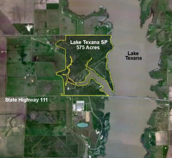
II. Discussion: Lake Texana State Park is located on the shores of its namesake lake in Jackson County. The 575 acre site was developed during the creation of Lake Texana on the Navidad River by the Bureau of Reclamation and was leased to TPWD in 1977 for a term of 50 years. The site opened to the public in September 1981 and contains a day use area and approximately 140 campsites. Visitation to the site was 43,877 in FY11, with FY11 revenues of $209,303 and total expenses of $516,747 (plus additional fringe benefit costs of approximately $95,000).
In accordance with the 82nd General Appropriation Act, and consistent with the TPWD Land and Water Resources Conservation and Recreation Plan, State Parks Division staff has been evaluating sites to determine whether or not local ownership and operation might be appropriate. As a result of these evaluations staff has determined that termination of the current lease for Lake Texana is necessary and should be effective August 31, 2012. The leased property will revert to the LNRA, which has expressed a willingness to assume operation of the site.
Committee Agenda Item No. 7
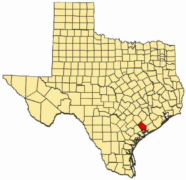
Exhibit A
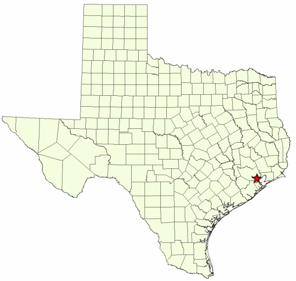
Location Map for Lake Texana State Park in Jackson County
Committee Agenda Item No. 7
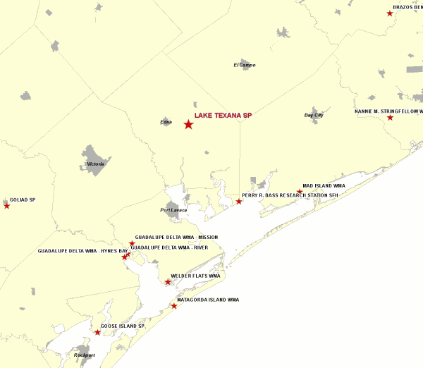
Exhibit B
Vicinity Map for Lake Texana SP, Jackson County
Committee Agenda Item No. 7
Exhibit C
Lake Texana State Park