Freshwater
Links:
Fishing
- Possession and Transport of Exotic Aquatic Species
- Licenses & Regulations
- ShareLunkers
- Fish Identification
- Fish Consumption
- Texas Freshwater Fisheries Center
Water Resources
- Texas Reservoir Levels
- US Army Corps of Engineers
- Texas Water Issues
- Golden Alga
- Aquatic Vegetation
TPWD
District Fisheries Office
11942 FM 848
Tyler, TX 75707
903-566-1615 x 213
Jake Norman, Biologist
More
Texas Lakes
Pat Mayse Lake
Public Access Facilities
Return to Pat Mayse fishing page
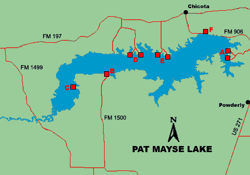
For details, choose a point on the map or a name in the chart below.

|
|
|
|
|
|
|
|
|
|
||
|
A: Sanders Cove |
||||||||||
|
B: Lamar Point |
||||||||||
|
C: Clay Bluff |
||||||||||
|
F: Tailrace |
Sanders Cove
- Located off FM 906 southeast of the dam
- Concrete boat ramps, one 1-lane and one 2-lane. Maximum parking capacity of 50.
- Fee required
- Open all year
- Operated by US Army Corps of Engineers (903) 732-4956
Lamar Point
- Located off FM 1500, which runs north from FM 1499 off 271, between Paris and Powderly
- Single-lane concrete ramp with maximum parking capacity of 30
- Fee required
- Open all year
- Operated by US Army Corps of Engineers (903) 732-3020
Clay Bluff
- Take FM 1500 north from FM 1499. Turn left on CR 34770 north of the old store.
- Single-lane concrete ramp
- No fee required
- Open all year
- Operated by Lamar County Pct. 3 (903) 784-6085
Pat Mayse West
- Located South of Forest Chapel off FM 197, west of the dam
- Two single-lane concrete ramps with parking for 15 vehicles
- Fee required
- Open year round
- Operated by US Army Corps of Engineers (903) 732-4955
Pat Mayse East
- Located south of Chicota on FM 197, west of the dam
- Two single-lane concrete ramps with maximum parking capacity of 30
- Fee required
- Open all year
- Operated by US Army Corps of Engineers (903) 732-3020
Tailrace Area
- Located below the dam, north on the gravel road off FM 906
- Bank access and gravel parking lot
- No fee required
- Operated by US Army Corps of Engineers (903) 732-3020