Fishing
- Possession and Transport of Exotic Aquatic Species
- Licenses & Regulations
- ShareLunkers
- Fish Identification
- Fish Consumption
- Texas Freshwater Fisheries Center
Water Resources
- Texas Reservoir Levels
- US Army Corps of Engineers
- Texas Water Issues
- Golden Alga
- Aquatic Vegetation
TPWD
District Fisheries Office
505 Staples Road
San Marcos, Texas 78666
(512) 353-0072
Patrick Ireland, Biologist
About the
Area
Local Information
- LCRA Parks & Recreation Areas
- Lake Travis Chamber of Commerce
- Burnet Chamber of Commerce
- Austin Chamber of Commerce
Nearby State Parks
More
Texas Lakes
Lake Travis
Public Access Facilities
Return to Lake Travis fishing page
BOATER ADVISORY: Zebra mussels have invaded this reservoir! CLEAN, DRAIN AND DRY your boat, trailer, livewells/bait buckets, and other gear before traveling to another water body. Draining water is required by law and possession and transport of zebra mussels is illegal.
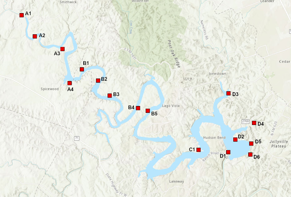
The Lower Colorado River Authority and Travis County Parks operate 15 parks on the reservoir. Several of these parks provide campgrounds, beaches, picnic areas, boat ramps and opportunities for shoreline fishing. Entrance and/or launch fees are charged at some parks. For details, choose a point on the map or a name in the chart below.
|
|
|
|
|
|
|
|
|
|
||
| A1: Camp Creek Park | ||||||||||
| A2: Shaffer Bend | ||||||||||
| A3: Narrows Recreation Area | ||||||||||
| A4: Grelle Recreation Area | ||||||||||
| B1: Turkey Bend | ||||||||||
| B2: Muleshoe Bend | ||||||||||
| B3: Gloster Bend | ||||||||||
| B4: Pace Bend/Collier Cove | ||||||||||
| B5: Pace Bend/Tatum Cove | ||||||||||
| C1: Arkansas Bend | ||||||||||
| D1: Mansfield Dam Park | ||||||||||
| D2: Bob Wentz at Windy Point | ||||||||||
| D3: Sandy Creek | ||||||||||
| D4: Cypress Creek | ||||||||||
| D5: Hippie Hollow | ||||||||||
| D6: Tom Hughes Park |