Central Texas Coastal Prairie River Floodplain
Geology
Typically occupying Quaternary alluvium adjacent to the Beaumont or Lissie Formations.
Landform
Terraces and margins of large creeks and rivers of the central coast including Tres Palacios Creek and the lower reaches of the Lavaca, Navidad, Guadalupe, San Antonio, and Nueces Rivers, as well as the Aransas and Mission Rivers.
Soils
Bottomland ecological site types, including loamy, clayey, and sandy sites.
Parent Description
This system occupies bottomland soils along the coastal portions of the Navidad, Lavaca, Guadalupe, San Antonio, Mission, Aransas, and Nueces Rivers (and their tributaries) as they cross the prairie surface of the Lissie and Beaumont Formations. The extent of floodplain forest along the Mission and Aransas rivers is somewhat limited. Those rivers that continue upstream beyond these Pleistocene formations transition to forests of the Southeastern Great Plains Floodplain system. The Nueces River shares some affinity with the Tamaulipan Floodplain system to the south, and drainages further to the south and west of the Nueces, as well as the Nueces upstream of the prairie formations are attributed to that system. Floodplain systems north and east of the Navidad River are attributed to the Columbia Bottomlands Forest and Woodland system. This system is characterized by a woodland and forest dominated by species such as Celtis laevigata (sugar hackberry), Celtis laevigata var. reticulata (netleaf hackberry), Ulmus crassifolia (cedar elm), Carya illinoinensis (pecan), Ulmus americana (American elm), Prosopis glandulosa (honey mesquite), and Fraxinus berlandieriana (Mexican ash) or Fraxinus pennsylvanica (green ash). Mixed deciduous / evergreen canopy may include Quercus fusiformis (plateau live oak) and Ehretia anacua (anacua) as significant components of the overstory. Sites dominated by Quercus fusiformis (plateau live oak) typically occur on less saturated sites such as slightly elevated situations. Less common species in the canopy may include Acer negundo (boxelder), Gleditsia triacanthos (honey locust), Quercus macrocarpa (bur oak), Populus deltoides (eastern cottonwood), Platanus occidentalis (American sycamore), Morus rubra (red mulberry), and Acacia farnesiana (huisache). Some wetter sites may be dominated by Salix nigra (black willow) or, less commonly, Taxodium distichum (baldcypress). Acer negundo (boxelder), Sapindus saponaria var. drummondii (western soapberry), Ungnadia speciosa (Mexican buckeye) and saplings of the overstory species may form a subcanopy. The shrub layer is often not well-developed, and contains species such as Sabal minor (dwarf palmetto), Ilex vomitoria (yaupon), Ilex decidua (possumhaw), Diospyros texana (Texas persimmon), Sideroxylon lanuginosum (gum bumelia), Prosopis glandulosa (honey mesquite), Acacia farnesiana (huisache), Condalia hookeri (brasil), and/or Cornus drummondii (roughleaf dogwood). Sabal minor (dwarf palmetto) or Ilex vomitoria (yaupon) may sometimes form a dense shrub understory. Some sites may represent dense shrublands dominated by Cephalanthus occidentalis (common buttonbush) or Forestiera acuminata (swamp privet), with a sparse overstory. Vines are commonly encountered, including species such as Ampelopsis arborea (peppervine), Vitis mustangensis (mustang grape), Smilax bona-nox (saw greenbrier), Toxicodendron radicans (poison ivy), and Campsis radicans (trumpet creeper). The ground layer can be well-developed and often dominated by graminoids, including Carex cherokeensis (Cherokee sedge), Carex crus-corvi (crowfoot sedge), Elymus virginicus (Virginia wildrye), Phanopyrum gymnocarpon (savannah panicum), Chasmanthium latifolium (creek oats), Leersia spp. (cutgrasses), Paspalum langei (rustyseed paspalum), Panicum obtusum (vine mesquite) Tripsacum dactyloides (eastern gamagrass), Carex bulbostylis (narrowleaf sedge), Carex tetrastachya (Britton's sedge), Oplismenus hirtellus (basketgrass), and Dichanthelium sphaerocarpon (roundseed panicgrass). Forbs, such as Malvaviscus arboreus var. drummondii (Drummond Turk's cap), Chloracantha spinosa (spiny aster), Verbesina virginica (frostweed), Calyptocarpus vialis (straggler daisy), Commelina erecta (erect dayflower), Allium canadense var. canadense (Canada wild onion), Myosotis macrosperma (scorpion weed), Nemophila phacelioides (baby blue-eyes), and the somewhat rare Tauschia texana (Texas tauschia) and Spigelia texana (Texas pinkroot), may also be found in these woodlands. Chloracantha spinosa (spiny aster) may sometimes form large, nearly monotypic in aspect, stands. Wetter, herbaceous dominated sites occur in these floodplains and may contain species such as Cyperus spp. (flatsedges), Eleocharis spp. (spikerushes), Zizaniopsis miliacea (Texas millet), Paspalum denticulatum (longtom), and Typha domingensis (southern cattail). The non-native Triadica sebifera (Chinese tallow) may be present to dominant in the canopy of occurrences of this system. Non-native grasses such as Cynodon dactylon (bermudagrass), Bothriochloa ischaemum var. songarica (King Ranch bluestem), Urochloa maxima (guineagrass), and Sorghum halepense (Johnsongrass) may also be present and sometimes dominate the ground layer to the exclusion of other species.
Ecological Mapping Systems
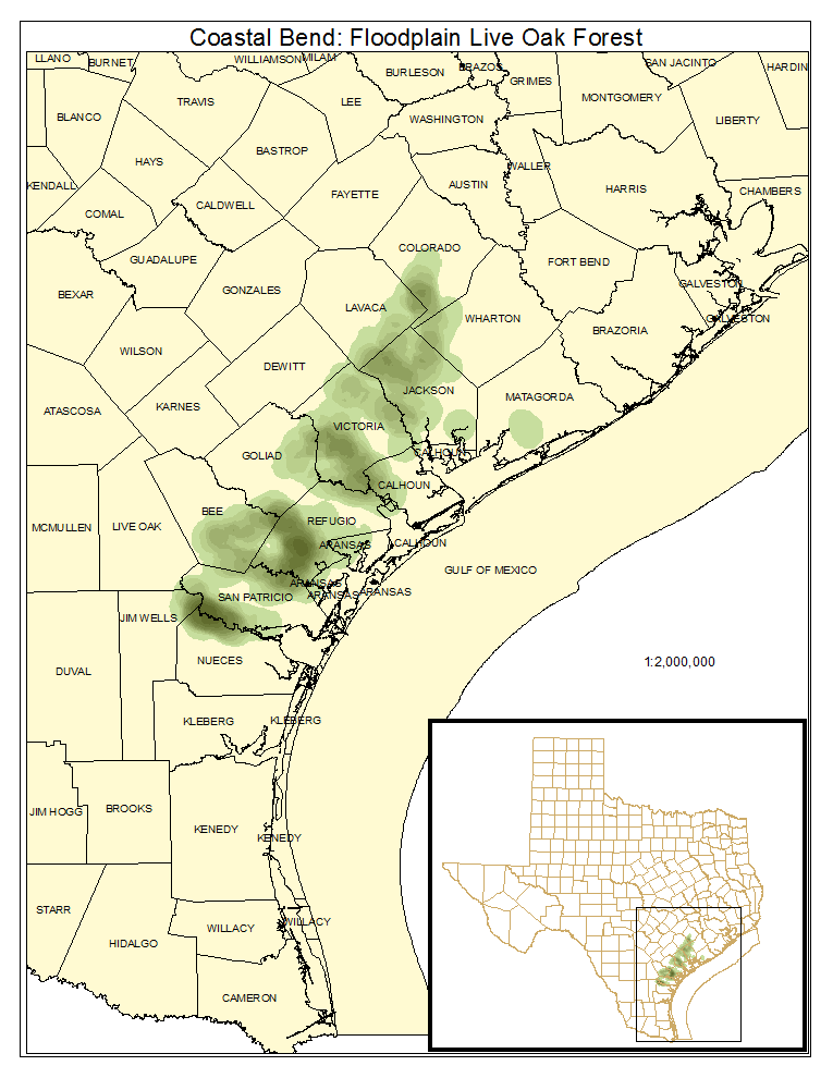
Coastal Bend: Floodplain Live Oak Forest
As described for the system, but with the canopy dominated by Quercus fusiformis (plateau live oak).
Distribution Map

Photos

Public Land Occurrence
Coastal Bend: Floodplain Live Oak / Hardwood Forest
Forests containing a mix of deciduous and broadleaf evergreen in the canopy. Broadleaf evergreen species include Quercus fusiformis (plateau live oak) and Ehretia anacua (anacua).
Distribution Map

Photos

Public Land Occurrence
Coastal Bend: Floodplain Hardwood Forest
As described for the system with primarily deciduous hardwoods in the canopy. Almost 45% of the system is mapped as this type.
Distribution Map

Photos

Coastal Bend: Floodplain Evergreen Shrubland
Evergreen shrublands on floodplains with species such as Sabal minor (dwarf palmetto), Rosa bracteata (Macartney rose), Zanthoxylum fagara (colima), Ehretia anacua (anacua), Baccharis halimifolia (eastern baccharis), and Acacia farnesiana (huisache).
Distribution Map

Photos

Public Land Occurrence
- None.
Coastal Bend: Floodplain Deciduous Shrubland
Shrublands dominated by species such as Prosopis glandulosa (honey mesquite), Acacia farnesiana (huisache), Cephalanthus occidentalis (common buttonbush), Forestiera acuminata (swamp privet), and/or Cornus drummondii (roughleaf dogwood). Some sites mapped as this type may be dominated by Chloracantha spinosa (spiny aster). Celtis laevigata (sugar hackberry) and Ulmus crassifolia (cedar elm) are common within this type.
Distribution Map

Photos

Public Land Occurrence
- None.
Coastal Bend: Floodplain Grassland
More than 22% of this system is mapped as this type, though most sites represent managed pasture and may be dominated by species such as Cynodon dactylon (bermudagrass), Bothriochloa ischaemum var. songarica (King Ranch bluestem), and Paspalum notatum (bahiagrass).
Distribution Map

Public Land Occurrence
- None.
Coastal Bend: Floodplain Herbaceous Wetland
Herbaceous wetlands typically dominated by sedges, wetland grasses, such as Paspalum denticulatum (longtom) or Zizaniopsis miliacea (Texas millet), and wetland forbs such as Polygonum spp. (smartweeds).
Distribution Map

Photos
