Conservation Committee
Wednesday, 9:00 am, January 23, 2008
Commission Hearing Room4200 Smith School Road
Austin, TX 78744
Approval of Previous Meeting Minutes
- Land and Water Plan Update
Staff: Robert Cook - Land Transfer - Taylor County - Transfer of Approximately 91.3 Acres at Abilene State Park - Permission to Begin the Public Notice and Input Process
Staff: Corky Kuhlmann - Land Transfer - Bexar County - Transfer of 23 Acres to National Park Service - San Antonio Missions National Historical Park - Permission to Begin the Public Notice and Input Process
Staff: Ted Hollingsworth - Land Sale - Palo Pinto County - Sale of Two Lots at Lake Mineral Wells Trailway (Action Item No. 13)
Staff: Ted Hollingsworth - Conservation Easement - Bastrop County - Acceptance of Conservation Easement at Bastrop State Park (Executive Session) (Action Item No. 14) Withdrawn
Staff: Ted Hollingsworth - Possible Land Donation - Palo Pinto County (Executive Session Only)
Staff: Ted Hollingsworth - Access Issues at Big Bend Ranch State Park (Executive Session Only)
Staff: Ted Hollingsworth - Facility Boundary Strategy for San Jacinto Battleground State Historic Site - Harris County (Executive Session Only)
Staff: Ted Hollingsworth
Committee Agenda Item No. 1
Presenter: Robert L. Cook
Conservation Committee
Land and Water Plan Update
January 2008
I. Executive Summary: Executive Director Robert L. Cook will briefly update the Commission on the status of the agency's efforts to implement the Land and Water Resources Conservation and Recreation Plan (the Plan).
II. Discussion: In 2001, the 77th Texas Legislature directed that the Texas Parks and Wildlife Department (TPWD) develop a Land and Water Resources Conservation and Recreation Plan (Tex. Park & Wild. Code §11.104). In November 2002, the Texas Parks and Wildlife Commission (the Commission) adopted the first Plan. A revised Plan was adopted by the Commission in January 2005. The Plan is available on the TPWD web site. Executive Director Robert L. Cook will update the Conservation Committee on TPWD's recent progress in achieving the Plan's Goals and Objectives as they relate to the Conservation Committee.
The Plan consists of 8 Goals and a total of 56 Objectives. The Goals stated in the Plan are as follows:
- Goal 1: Improve access to the outdoors.
- Goal 2: Preserve, conserve, manage, operate, and promote agency sites for recreational opportunities, biodiversity, and the cultural heritage of Texas.
- Goal 3: Assist landowners in managing their lands for sustainable wildlife habitat consistent with their goals.
- Goal 4: Increase participation in hunting, fishing, boating and outdoor recreation.
- Goal 5: Enhance the quality of hunting, fishing, boating and outdoor recreation.
- Goal 6: Improve science, data collection and information dissemination to make informed management decisions.
- Goal 7: Maintain or improve water quality and quantity to support the needs of fish, wildlife and recreation.
- Goal 8: Continuously improve TPWD business management systems, business practices and work culture.
Committee Agenda Item No. 2
Presenter: Corky Kuhlmann
Conservation Committee
Land Transfer - Taylor County
Abilene State Park
January 2008
I. Executive Summary: Texas Parks and Wildlife Department (TPWD) has a request from The Texas Trails Council, Boy Scouts of America to transfer approximately 91.3 acres of land at Camp Tonkawa Boy Scout Camp/Abilene State Park, Abilene, Texas.
II. Discussion: The Camp Tonkawa Boy Scout Camp consists of approximately 191.3 acres of land of which 91.3 acres is leased by the Boy Scouts from TPWD and was originally part of Abilene State Park. This lease originated on June 7, 1949 for a term of 19 years, with a renewed lease expiring in 2018. The property on which the camp is located was transferred from the City of Abilene to TPWD in 1933.
TPWD has received a request from The Texas Trails Council, Boy Scouts of America for the transfer of 91.3 acres of State Park land to be used as an addition to Camp Tonkawa Boy Scout Camp. This transfer would provide more opportunities for the scouts to build new facilities and or renovate existing facilities. To ensure compliance with deed restrictions, staff has been discussing with staff from the City of Abilene the transfer of the 91.3 acres back to the City, which would enable the City to enter a transaction directly with the Boy Scouts.
Staff would like to begin the process of providing public notice and obtaining public input regarding a proposed transfer of approximately 91.3 acres of land at Camp Tonkawa Boy Scout Camp/Abilene State Park, Taylor County, Texas.
Attachments - 1
- Exhibit A – Location Map
Committee Agenda Item No. 2
Exhibit A
Location Map
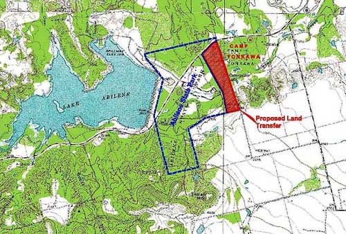
For help in interpreting this map, please contact Corky Kuhlmann.
Committee Agenda Item No. 3
Presenters: Ted Hollingsworth
Conservation Committee
Land Transfer - Bexar County
January 2008
I. Executive Summary: The Texas Parks and Wildlife Commission voted in 2000 to transfer its remaining interest in the San Jose Mission State Historic Site (SHS) to the National Park Service (NPS). Title conflicts prevented the transfer of the site at the time. Although the title conflicts have not been resolved, NPS now requests that we proceed with the transfer. NPS will become responsible for resolving any remaining title issues.
II. Discussion: San Jose Mission SHS was acquired between 1941 and 1977. In 1978, Congress created the San Antonio Missions National Historical Park, the boundary of which includes all of the SHS. In 1983, Texas Parks and Wildlife Department (TPWD) entered into a cooperative agreement with the NPS that placed all TPWD properties that comprise Mission San Jose under NPS management. NPS also manages artifacts associated with the site under a loan agreement.
Although TPWD no longer treats Mission San Jose as an SHS, the department still owns 17 acres and leases 6 acres. In 2000, TPWD staff recommended transfer of all interest at San Jose Mission to NPS, and the TPW Commission concurred. The transfer has not occurred due to title conflicts. However, the NPS now advises that it will accept transfer of all interests of TPWD at San Jose Mission, without the necessity of resolving those conflicts. NPS has ordered an appraisal of the property per their procedures. Staff requests permission to begin the process of public notification and solicitation of public input. A local public hearing will be held before staff returns to the TPW Commission with a recommendation.
Attachments - 1
- Exhibit A – Location Map
Committee Agenda Item No. 3
Exhibit A
San Jose Mission Location Map
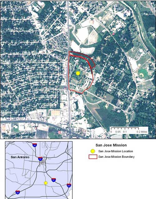
For help in interpreting this map, please contact Ted Hollingsworth.
Committee Agenda Item No. 6
Presenters: Ted Hollingsworth
Conservation Committee
(Executive Session Only)
Possible Land Donation - Palo Pinto County
January 2008
I. Executive Summary: Staff will brief and update the Texas Parks and Wildlife Commission on the status of efforts to acquire land for a new State Park in Palo Pinto County through donation or a combination of donation and purchase.
II. Discussion: Through a successful partnership with the Trust for Public Land and others, Eagle Mountain Lake was sold to a public conservation buyer earlier this year with net proceeds of approximately $9.2 million to Texas Parks and Wildlife Department (TPWD). The sale proceeded with the caveat that the proceeds of the sale would be used to acquire and/or develop a new state park more consistent with the letter and intent of the Land and Water Conservation and Recreation Plan.
The goal of staff is to structure one or more transactions that would result in the acquisition of 4000 - 6000 contiguous acres of land within the land sale proceeds budget created by the sale of Eagle Mountain Lake, with sufficient funds remaining for site assessment, planning, and "Phase One" site development for public use.
Attachments - 1
- Exhibit A – Location Map
Committee Agenda Item No. 6
Exhibit A
Location Map for Potential New Park Donation
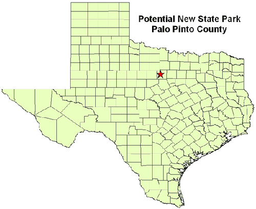
For help in interpreting this map, please contact Ted Hollingsworth.
Committee Agenda Item No. 7
Presenters: Ted Hollingsworth
Conservation Committee
(Executive Session Only)
Access Issues at Big Bend Ranch State Park
January 2008
I. Executive Summary: Staff is working with Presidio and Brewster Counties and with the Big Bend Advisory Committee to mitigate or eliminate barriers to public use.
II. Discussion: Big Bend Ranch State Park is Texas' largest state park, at more than 300,000 acres. It offers the greatest potential for true wilderness experiences of any site in the state. Texas Parks and Wildlife Department (TPWD) has recently completed a Public Use Plan aimed at providing controlled public access to this very special site, while protecting its unique biological and aesthetic resources.
Responding to a recommendation from the Advisory Committee, in January 2007, TPWD made a formal request to Presidio County to dedicate three historic roads into Big Bend Ranch as public roads. TPWD continues to work with Presidio County officials to achieve the goal of dedicated permanent public access into the park.
Attachments - 2
Committee Agenda Item No. 7
Exhibit A
Location of Big Bend Ranch State Park
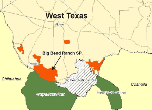
For help in interpreting this map, please contact Ted Hollingsworth.
Committee Agenda Item No. 7
Exhibit B
Location of Historic Access Roads to Big Bend Ranch State Park
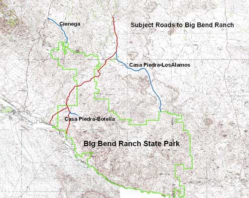
For help in interpreting this map, please contact Ted Hollingsworth.
Committee Agenda Item No. 8
Presenters: Ted Hollingsworth
Conservation Committee
(Executive Session Only)
Facility Boundary Strategy for San Jacinto Battleground State Historic Site
Harris County
January 2008
I. Executive Summary: Recent archeological and archival research gives us a much clearer picture of the Battle of San Jacinto that took place April 21, 1836. Staff seeks ways to protect components of the battleground not currently included in the State Historic Site.
II. Discussion: The battleground at San Jacinto, now managed by Texas Parks and Wildlife Department (TWPD) as the San Jacinto Battleground State Historic Site (SHS), preserves the location where Texas won independence from Mexico on April 21, 1836, in one of the most decisive battles in the history of the Western Hemisphere. This SHS is arguably the most significant cultural resource in Texas. Since it was almost sixty years after the battle before veterans marked the locations of key events on the ground, and since Texian and Mexican accounts of the battle vary, historians have questioned the traditional location and interpretation of the battle. Dramatic changes due to subsidence, dredging, agriculture and industry, further complicate the historic landscape. Over the past ten years, TPWD staff, historians and archeologists working under contract to TPWD, have meticulously reconstructed the battleground of 1836, revisited early accounts of the battle, and recast our understanding of how the battle unfolded. Staff is exploring options for protecting sites associated with the battle through potential conservation easements and acquisitions.
Attachments - 1
- Exhibit A – Location Map
Committee Agenda Item No. 8
Exhibit A
Location of San Jacinto Battleground SHS and Battle-related Sites

For help in interpreting this map, please contact Ted Hollingsworth.