Fishing
- Possession and Transport of Exotic Aquatic Species
- Licenses & Regulations
- ShareLunkers
- Fish Identification
- Fish Consumption
- Texas Freshwater Fisheries Center
Water Resources
- Texas Reservoir Levels
- US Army Corps of Engineers
- Texas Water Issues
- Golden Alga
- Aquatic Vegetation
12861 Galm Road #7
San Antonio, Texas 78254
(210) 688-9460 or 688-9516
Mitch Nisbet, Biologist
Local Information
- National Park Service
HCR #3, Box 5J
Del Rio, Texas 78840
(830) 775-7491
amis_interpretation@nps.gov
Nearby State Parks:
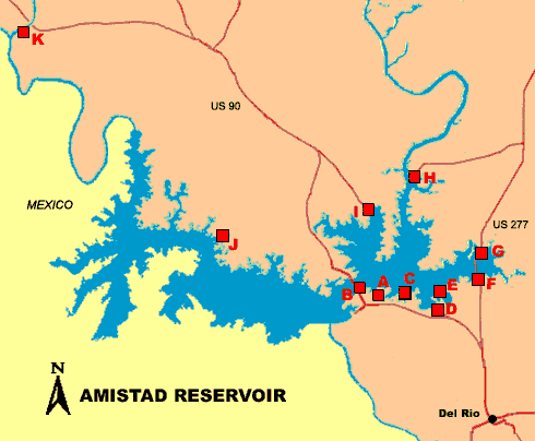
Amistad Reservoir
Public Access Facilities
Return to Amistad fishing page
BOATER ADVISORY: Zebra and Quagga mussels have invaded this reservoir! CLEAN, DRAIN AND DRY your boat, trailer, livewells/bait buckets, and other gear before traveling to another water body. Draining water is required by law and possession and transport of invasive mussels is illegal.
Lake access and facilities are provided by the National Park Service. Any boat with a motor must have a boat pass ($4 per day, $10 for a 3-day pass, or $40 per year) to enter the lake. For more details, choose a point on the map or a name in the chart below. Visit the NPS website for information on camping facilities and fees.
|
|
|
|
|
|
|
|
|
|
||
|
A: Diablo East |
||||||||||
| B: Governors Landing | ||||||||||
| D: Spur 454 | ||||||||||
| E: San Pedro | ||||||||||
|
F: 277 South |
||||||||||
| G: 277 North | ||||||||||
|
H: Rough Canyon |
||||||||||
| I: Spur 406 | ||||||||||
|
J: Box Canyon |
||||||||||
|
K: Pecos River |
Diablo East
- Take US 90 west from Del Rio and turn right just before crossing Lake Amistad.
- Long, steep, concrete 4-lane boat ramp
- Open all year
- Maintained by National Park Service (830) 775-7491
Governors Landing
- Located beneath US 90 bridge. Take spur 349 to Amistad Dam, then take first right turn.
- No boat ramp; bank fishing available
- Open all year
- Maintained by National Park Service (830) 775-7491
Black Brush Point
- Located off of US 90 West approximately 6 miles out of Del Rio
- Concrete ramp, accessible when lake surface is above 1081 feet elevation
- Fishing pier available
- Open all year
- Maintained by National Park Service (830) 775-7491
Spur 454
- Take Spur 454 off US 90 West and follow to boat ramp
- Open all year
- Maintained by National Park Service (830) 775-7491
San Pedro
- Take Spur 454 off US 90 West, then take second right
- Maintained by National Park Service (830) 775-7491
US 277 South
- Located at east end of the lake, south end of US 277 bridge
- Boat launch and fishing pier available
- Open all year when conditions permit
- Maintained by National Park Service (830) 775-7491
US 277 North
- Located at north end of US 277 bridge
- Concrete ramp is located east side of campground. When lake level is below the bridge, boats may be launched from the gravel bank.
- Open all year when conditions permit
- Maintained by National Park Service (830) 775-7491
Rough Canyon
- Located approximately 20 miles out of Del Rio on R2 off US 277 North
- Long, steep 4-lane concrete ramp, usable at most lake levels
- Open all year
- Maintained by National Park Service (830) 775-7491
Spur 406
- Located on the north side of the lake. From US 90, turn southeast on Spur 406 and follow to end of road.
- Open all year
- Maintained by National Park Service (830) 775-7491
Box Canyon
- Take US 90 from Del Rio. Approximately 2 miles after crossing Lake Amistad, turn left onto Box Canyon Estates Road.
- Concrete ramp, usable at most lake levels
- Fishing pier available
- Open all year
- Maintained by National Park Service (830) 775-7491
Pecos River
- Located off US 90 approximately 40 miles west of Del Rio, near the point where the Pecos joins the Rio Grande
- Concrete ramp
- Fishing pier
- Open all year
- Maintained by National Park Service (830) 775-7491