Freshwater
Links:
Fishing
- Possession and Transport of Exotic Aquatic Species
- Licenses & Regulations
- ShareLunkers
- Fish Identification
- Fish Consumption
- Texas Freshwater Fisheries Center
Water Resources
- Texas Reservoir Levels
- US Army Corps of Engineers
- Texas Water Issues
- Golden Alga
- Aquatic Vegetation
TPWD
District Fisheries Office
8684 LaVillage Avenue
Waco, Texas 76712
(254) 666-5190
John Tibbs, Biologist
About the
Area
Nearby State Parks
More
Texas Lakes
Comanche Trails Park Lake
Fish Habitat Structures
Add short descriptions. All descriptions of depth and distance from shore are dependent on water level and may change throughout the year as water level fluctuates. Coordinates are also available in downloadable files.
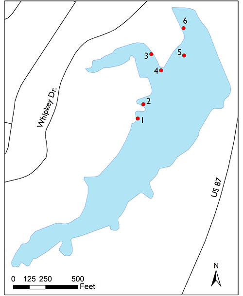
| Site | Latitude | Longitude |
Depth | Description |
|---|---|---|---|---|
| 1 | 32.222473 |
-101.472453 | 4-6 feet | 12 – 20-inch-tall root wad structures laid out in a row, 30-40 feet from shore |
| 2 | 32.222778 | -101.472318 | 6-7 feet | 3 – 20-inch-tall root wad structures |
| 3 | 32.223853 | -101.472136 | 6-8 feet | 7 – 20-inch-tall root wad structures, 30-40 feet from shore |
| 4 | 32.223508 | -101.471882 | 8-10 feet | 5 – 40-inch-tall trophy tree structures 30-50 feet from shore |
| 5 | 32.223835 | -101.471309 | 10-12 feet | 5 – 60-inch-tall trophy tree structures. |
| 6 | 32.224417 | -101.471334 | 3-6 feet | 18 – 20-inch-tall root wad structures laid out in a row, 30-40 feet from shore |