Fishing
- Licenses & Regulations
- ShareLunkers
- Fish Identification
- Fish Consumption
- Texas Freshwater Fisheries Center
Water Resources
- Texas Reservoir Levels
- US Army Corps of Engineers
- Texas Water Issues
- Golden Alga
- Aquatic Vegetation
5325
N. 3rd
Abilene, Texas 79603
(325) 692-0921
Michael Homer, Biologist
Local Information
- Stamford Chamber of Commerce
PO Box 1206
Stamford, Texas 79553
(325) 773-2411 - Stamford Marina
Rt 2, Box 850
Haskell, Texas 79521
(325) 773-2095 - Anchor Marina
Rt 2, Box 1775
Haskell, Texas 79521
(940) 864-3779 - Haskell County (940) 864-2451
Stamford Reservoir
Quick Links: Fishing Regulations | Angling Opportunities | Cover & Structure | Tips & Tactics
Lake Characteristics
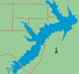
Location: 10 miles east of Stamford on
Paint Creek, a tributary of the Clear Fork of the Brazos River
Surface area: 5,124 acres
Maximum depth: 36 ft., mean depth
11 ft.
Impounded: 1953
Water Conditions
Current Lake Level
Conservation Pool Elevation: 1,417 ft. msl
Fluctuation: Severe, 4-10
feet annually
Normal Clarity: Turbid, visibility 1-2 ft.
Reservoir Controlling Authority
City of Stamford
201 E. McHarg St.
Stamford, Texas 79553
(325) 773-2723
Aquatic Vegetation
Stands of bulrush and some cattail, pondweed and lily pads
Predominant Fish Species
Lake Records
Current
Fishing Report
Stocking History
Latest Survey Report
Lake Maps
A contour map is available. Download the map or pick up a copy at the Abilene fisheries office, (325) 692-0921.
Fishing Regulations
All species are currently managed under statewide regulations.
Angling Opportunities
| Species | Poor | Fair | Good | Excellent |
|---|---|---|---|---|
| Largemouth Bass | ||||
| Blue & Channel Catfish | ||||
| Crappie | ||||
| White Bass | ||||
| Sunfish |
Fishing Cover/Structure
The primary structure in this lake is rock, with areas of bulrush and cattail. TPWD has placed fish habitat structures in the lake, with support from local governments and fishing clubs. Anglers may use GPS in conjunction with a fish finder to locate these structures.
Use the Habitat Structure Viewer for an interactive map of fish habitat structures and downloadable GPS coordinates.
Tips & Tactics
Low water levels and turbid water can make fishing a challenge. Water levels can and do fluctuate dramatically. Anglers should focus on the cover and structure available in the lower reservoir near the dam and power plant. Spring and summer are the best times of year for largemouth bass. Focus attention on bulrush or cattail points with soft plastics or flipping jigs when the lake is up. In low water conditions, concentrate on stumps and rocks with crankbaits or spinnerbaits. Spinnerbaits and suspending baits are good options for summer and topwater lures are good early and late in the day. Diving baits that have a lot of action and bump the bottom will attract strikes when visibility is poor. Crappie are abundant in the reservoir. Locate structure such as old trees or rock drop-offs or humps, then vertically fish jigs or minnows as close to the structure as possible.
