
Conservation Opportunity Areas of Texas
About the Model
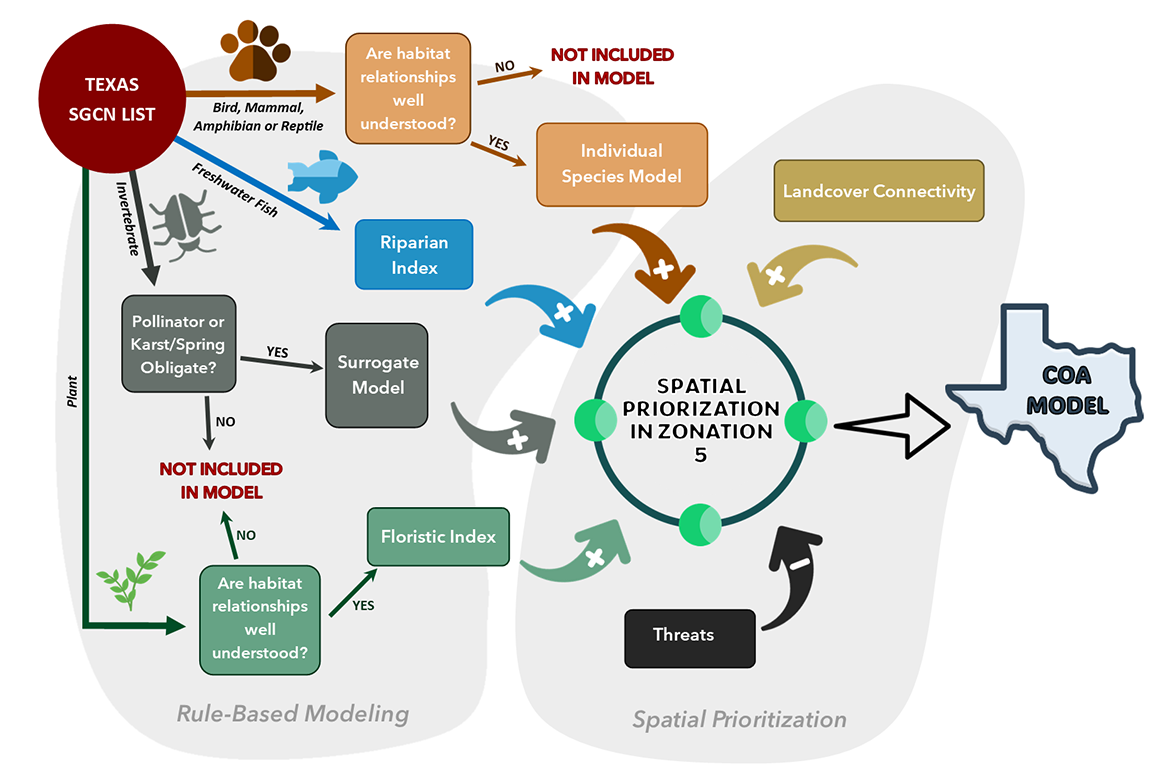
The Conservation Opportunity Areas (COA) of Texas model highlights places across the state where conservation or restoration actions can have the greatest impact. It uses the Ecological Mapping Systems of Texas dataset along with several other ecological factors, including:
- Species of Greatest Conservation Need (SGCN) and other target species
- Conservation threats
- Landcover connectivity
- Restoration potential
- Landscape fragmentation
Together, these inputs help users identify areas that support important species, habitat and natural communities. The COA is designed as a landscape-level decision-support tool that can guide strategic conservation planning, restoration efforts and management actions, including those outlined in the Texas State Wildlife Action Plan.
Land use or other activities within these areas will not be subject to any new regulations or restrictions due to this model. The data presented are based on the best available information at the time of data analysis; as such, recent changes to the landscape and to wildlife habitat may not be reflected.
How to Use the Model
The COA can support a wide range of conservation and planning needs:
- Land Use Planning: identifying areas to avoid or prioritize
- Grant Applications: strengthening proposals and decisions with ecological justification
- Habitat Restoration: prioritizing restoration efforts where it could have the greatest impact
- Public Education: helping Texans learn about local habitats and their ecological value
Current Model Version
The current version of the model is v2026.
Integration of TPWD's Natural Resource Divisions
The COA ties together conservation priorities from all three Natural Resource Divisions: Coastal Fisheries, Wildlife and Inland Fisheries and displays their spatial data in one place.
Coastal Fisheries
Coastal SGCN species and habitat data inform the Conservation Opportunity Coastal Index, a companion model that highlights conservation, research, and restoration opportunities along the Texas coast.
Wildlife
SGCN and target species important to the Wildlife Division are incorporated directly into the COA model.
Inland Fisheries
Data from the Native Fish Conservation Areas database are included as an input layer representing Inland Fisheries priorities, with both modeled inputs and a separate summary layer available.
Methodology Summary
The COA model incorporates a variety of ecological datasets, including observation records and habitats for SGCN and other target species, riparian and coastal priorities, mapped conservation threats, and connectivity between valuable landcover types. Spatial prioritization software evaluates all input data to produce a modeled conservation value.
These values are combined with information on potential restoration effort and landscape fragmentation to create qualitative categories that highlight habitat importance and potential management actions (conservation vs. restoration focus). These categories can be used to identify areas where natural communities, critical habitats, SGCN and other indicator species may occur, supporting ecosystem-based management and planning.
The Conservation Opportunity Coastal Index combines expert input, key coastal habitat data, and 40 years of species observations. It includes major habitat types such as oyster and serpulid reefs, seagrass beds, mangroves, and salt marshes, along with environmental factors like salinity and proximity to tidal passes and river inlets. The index focuses on species closely tied to these habitats, and while it does not predict species presence, localized observations help highlight areas where targeted research or conservation efforts may be most effective.
COA Updates
The COA will be updated as new data become available, including changes to the SGCN list and updated datasets, such as the Ecological Mapping Systems of Texas. Although the model is designed to support updates to the Texas State Wildlife Action Plan, updates within the 10-year SWAP cycle will occur. Information regarding updates to the COA model and associated applications can always be available on this page.
Recent Updates:
- July 2026: COA v2026 officially launched and available for online viewing or download by ecoregion. Download data on the Native Fish Conservation Areas and Conservation Opportunity Coastal Index directly from the COA Web Viewer.
Access the COA Data
- Download Data by Ecoregion
Download COA data in Geodatabase (GDB) format and can be opened in GIS programs such as ArcGIS or QGIS. This option is best for planners, researchers, and GIS users who need spatial data for analysis. - COA Data Explorer
View the COA model in an Esri Experience Builder. Explore conservation values across Texas, zoom to your area of interest, and learn more about the model inputs and categories. - COA Variable and Categorization Methodology (v2026)
A supporting PDF summarizing how COA categories were developed. Useful for grant applications, project justification, and understanding how conservation and restoration potential were assigned. - COA Metadata (v2026): Coming Soon
Detailed metadata describing all COA model inputs, processing steps, and attribute definitions. Ideal for GIS users and partners who need technical documentation.