- Table of Contents
- Foreword
- Introduction
- Texas Waterway Map
- Map Key
- East Texas Waterways
- Central Texas Waterways
- Major Waterways:
- Blanco River
- Bosque River
- Brazos River
- Colorado River
- Concho River
- Frio River
- Guadalupe River
- Lampasas River
- Lavaca River
- Leon River
- Little River
- Llano River
- Medina River
- Navidad River
- Nueces River
- Paluxy River
- Pedernales River
- San Antonio River
- San Bernard River
- San Gabriel River
- San Marcos River
- San Saba River
- Wichita River
- Seasonal and Restrictive Waterways
- Major Waterways:
- West Texas Waterways
An Analysis of Texas Waterways
A Report on the Physical Characteristics of Rivers, Streams, and Bayous in Texas
Major Waterways of Central Texas
Lampasas River
The Lampasas River rises in western Hamilton County and flows approximately 100 miles southeast through Lampasas, Burnet, and Bell Counties. The river unites with the Leon River to form the Little River just south of Belton. Flowing through rugged hill country, the Lampasas contains heavily vegetated banks. The waterway is characterized by low water levels most of the time. However, during periods of heavy rains, the river becomes an exciting recreational corridor to a scenic and interesting area.
Farm-to-Market 1047 to Rumley
(Not mapped)
47 miles
The upper reaches of the Lampasas River flow through a region of Central Texas that is typical of the Edwards Plateau. Here, limestone bluffs are prominent and thick vegetation is abundant along both banks of the river. The upper reaches contain low water levels for most of the year and the river is suitable for recreational use only during periods of high water following a good rain. In addition, the river along this section is very narrow, and overhanging branches and limbs are a problem to recreationists. There are many access points on the 47-mile section between FM 1047 and Ranch Road 580. Waterway features and distance between each are as follows:
FM 1047 crossing - 15 miles
southwest of Hamilton. County
road crossing off US 84-8 miles
west of Evant. (7 miles)
US 84 crossing - 7 miles west of
Evant. (2 miles)
County road crossing off US 281 -
24 miles north of Lampasas.
(7 miles)
County road crossing off US 281 -
22 miles north of Lampasas.
(4 miles)
County road crossing off US 281 -
21 miles north of Lampasas.
(1.5 miles)
US 281 crossing - 15 miles north
of Lampasas. (12 miles)
Ranch Road 1690 crossing - 13
miles northeast of Lampasas.
(8 miles)
Ranch Road 580 crossing - 10 miles
northeast of Lampasas.
Approximately 50 feet of shoreline
are available on the road right-of-way. (6 miles)
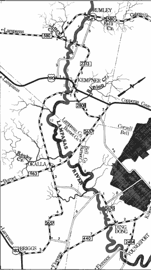
Lampasas River
Rumley to Youngsport
42 Miles
Rumley to Youngsport
42 miles
This 42-mile section of the Lampasas River flows through the counties of Lampasas, Burnet, and Bell. Located upstream from Stillhouse Hollow Reservoir, the river passes through limestone formations typical of the Edwards Plateau. During high water periods, recreational use of this section if feasible. Many small rapids add interest and excitement to this section. Normal water levels are relatively low, and several shallow areas are found. However, after heavy rains around the upper reaches in Hamilton County, recreational use is possible. Water quality is very good. There also exists an abundance of public road crossings along this stretch of the Lampasas. However, some of the crossings are fenced, and access is difficult at these points. Waterway features and distance between each are as follows:
Ranch Road 580 crossing - 10 miles northeast of Lampasas and 1 mile east
of Rumley. Reportedly, 50 feet of shoreline are available on the highway
right-of-way.
Ranch Road 2313 crossing - 5 miles
north of Kempner. Reportedly,
50 feet of shoreline are available
on the highway right-of-way.
(4 miles)
Lucy Creek - on the right. (0.5 mile)
County road crossing - between
Ranch Road 2313 and US 190,
4 miles of Kempner. (0.5 mile)
US 190 crossing - 1 mile west of
Kempner. Reportedly, fifty feet of
shoreline are available on the
highway right-of-way. (3 miles)
County road crossing - off US 190,
1 mile south of Kempner.
(2 miles)
Binion Creek on the left - 1 mile
below the previous crossing.
(1 mile)
Rocky Creek on the right - 1 mile
above FM 963 crossing.
(10 miles)
FM 963 crossing - 1 mile north of
the small town of Okalla.
(1 mile)
County road crossing - off FM 2670,
9 miles southwest of Killeen.
(8 miles)
FM 440 crossing - 10 miles south
west of Killeen at Ding Dong.
Steep banks are found at this
crossing. (5 miles)
County road crossing - west of
FM 2484, 11 miles south of
Killeen. (6 miles)
County road crossing - east of
FM 2484, 11 miles south of
Killeen. (1 mile) Stillhouse
Hollow Reservoir is located just
below this site.
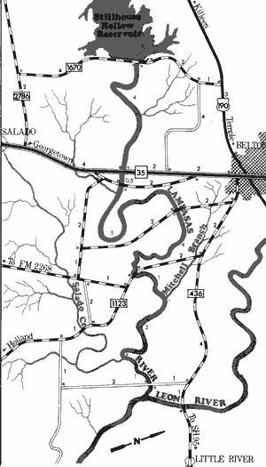
Lampasas River
Stillhouse Hollow Reservoir to Leon River
17.5 Miles
Stillhouse Hollow Reservoir to Leon River
17.5 miles
This 17.5 mile section of the Lampasas River below Stillhouse Hollow Dam in Bell County depends upon water releases from the dam before recreational use is feasible. A flow of between 200 and 300 cubic feet per second (CFS) reportedly, is the optimum level for safe recreational use.
The banks are heavily vegetated with elm, willow, and sycamore, and become fairly steep at most of the road crossings. Access points are plentiful on this section, since there are six public roads which cross the river. Water quality is clear below Stillhouse Hollow Dam, but becomes increasingly muddy as the river moves downstream. By the time the Lampasas reaches the confluence with the Leon River, the water moves very slowly between steep, muddy banks. There are no rapids of any consequence along this section of the waterway. Waterway features and distance between each are as follows:
FM 1670 crossing - immediately below
Stillhouse Hollow Dam.
IH 35 crossing - 2 miles south of Belton.
(4 miles)
County road crossing off IH 35 - 2 miles
south of Belton. (0.5 mile)
County road crossing off IH 436 - 2 miles
southeast of Belton. (5 miles)
FM 1123 crossing - 3 miles southeast of
Belton. (4 miles)
Mitchell Branch - enters on the left.
(1 mile)
Salado Creek - enters on the right.
(2 miles)
County road crossing off FM 436 - 5 miles
southeast of Belton. (1 mile) About 0.5
mile downstream from the previous
crossing, the Lampasas River meets
the Leon river to form the Little River.
Lavaca River
A coastal river flowing through Lavaca and Jackson Counties, the Lavaca has only a small watershed and depends entirely upon runoff for its flow. Thus, the stream is intermittent in its upper reaches and its flow is restricted. However, rainfall in the coastal plains is usually substantial and as the river nears the vicinity of Edna in Jackson County, the flow becomes sufficient for recreational use. Like most coastal river, the Lavaca River is scenic and hazards to recreational use are virtually nonexistent.
Moulton to Navidad Community Crossing
(Not mapped)
68 miles
The upper reaches of the Lavaca River are basically intermittent because of several factors. The river is not spring-fed, there is only a small watershed, and the river depends entirely upon runoff for its flow. During periods of heavy rainfall when flooding conditions are present, the upper reaches have sufficient water for recreational use. However, the river on this section is entirely seasonal, and recreational use of the lower section near the Gulf appears more feasible.
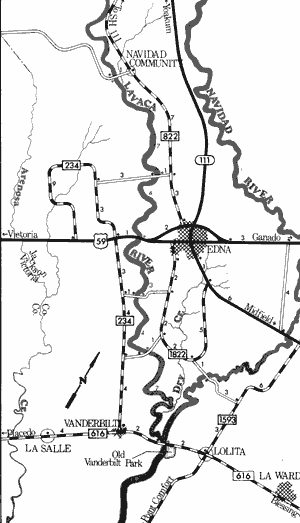
Lavaca River
Navidad Community Crossing to Old Vanderbilt Park
25.5 Miles
Navidad Community Crossing to Old Vanderbilt Park
25.5 miles
This 25.5-mile section of the Lavaca River in Jackson County is typical of those rivers flowing within the coastal plains. The river takes a meandering course and flows slowly to the Gulf of Mexico. The banks of the waterway are heavily vegetated with coastal hardwoods. No particular hazards exist, with the exception of an occasional log jam. The river is not very wide, and overhanging limbs and branches are a problem to recreationists. Because of heavy rains associated with the coastal plains, this section usually has sufficient water for recreational use. Waterway features and distance between each are as follows:
Navidad Community Crossing - county road
crossing off FM 822, 9 miles northwest
of Edna.
County road crossing - off FM 822, 3 miles
northwest of Edna. (7 miles)
US 59 crossing - 1 mile west of Edna.
(4 miles)
County road crossing - between FM 1822
and FM 234, 3 miles south of Edna.
(3 miles)
County road crossing - between FM 1822
and FM 234, 5 miles south of Edna.
(4 miles)
FM 616 crossing - 10 miles southeast of
Edna. (7 miles)
Old Vanderbilt Park - 2 miles west of Lolita.
Good access is available. (0.5 mile)
The Lavaca River empties into Lavaca
Bay 10 miles downstream.
Top of Page | Table of Contents