- Table of Contents
- Foreword
- Introduction
- Texas Waterway Map
- Map Key
- East Texas Waterways
- Central Texas Waterways
- Major Waterways:
- Blanco River
- Bosque River
- Brazos River
- Colorado River
- Concho River
- Frio River
- Guadalupe River
- Lampasas River
- Lavaca River
- Leon River
- Little River
- Llano River
- Medina River
- Navidad River
- Nueces River
- Paluxy River
- Pedernales River
- San Antonio River
- San Bernard River
- San Gabriel River
- San Marcos River
- San Saba River
- Wichita River
- Seasonal and Restrictive Waterways
- Major Waterways:
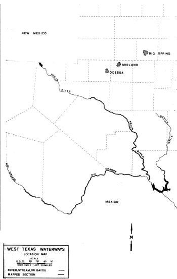
- West Texas Waterways
An Analysis of Texas Waterways
A Report on the Physical Characteristics of Rivers, Streams, and Bayous in Texas
Major Waterways of West Texas
This section contains maps and an analysis of the more popular and scenic sections of rivers in West Texas. It has been found that West Texas waterways are characterized by fluctuating water levels, an arid desert environment, many excellent rapids and outstanding scenic qualities.
Devil's River
Devil's River
Rising in northwest Sutton County, the Devils River flows south through Val Verde County to join the Rio Grande near Del Rio. The total length of the river is approximately 100 miles. Because of the arid nature of the region through which it flows, the Devils River is intermittent for much of its length. In some stretches, the river goes completely underground then rises again downstream. Many springs add water to the river throughout its course. Also, most of the creeks that flow into the river are spring-fed. Therefore, the normal volume of water in the river progressively increases downstream. The water-quality of the Devils River is excellent, and many consider it to be the cleanest naturally flowing stream remaining in Texas. The water is filtered through sand and gravel deposits and is so clear that the bottom can seen even in deep pools. Water levels are subject to extreme fluctuations, from flash floods to a trickle; therefore, the river's potential for recreational use is seasonal, except in the far downstream sections. The overall scenic beauty, water quality, remoteness, and white-water recreational experiences found on the Devils River mark it as one of the few rivers in Texas retaining truly "wild" characteristics.
Farm-to-Market 189 to Baker's Crossing
(Not mapped)
36 miles
The upper reaches of the Devils River, from FM 189 to the southernmost crossing of State Highway 163 is intermittent. In some stretches, the river flows completely underground, but eventually rises again downstream. Many springs feed the river, and the volume of water in the river progressively increases as the river moves downstream. Water levels are subject to extreme fluctuations, from flash floods to a trickle. Therefore, the potential for recreational use of this upper section is restricted to seasonal use. The water quality is exceptional since it flows over sand and gravel. Numerous rapids exist.
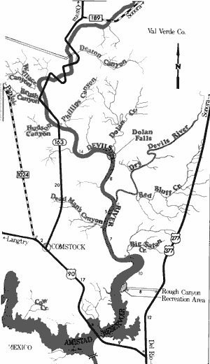
Devil's River
State Highway 163 to Rough Canyon Recreation Area
44 Miles
State Highway 163 to Rough Canyon Recreation Area
44 miles
This 44-mile section of the Devils River is one of the finest wilderness waterways in Texas. Recreational use is possible below the southernmost SH 163 crossing at the low water bridge. The property around the bridge is private. Although the water levels may fluctuate, there is usually enough water for recreational use on a year-round basis. The river flows through a narrow valley which becomes almost canyon-like at times. In many places the riverbed is solid rock which has been channeled and fluted by water action. Numerous rapids exist, and in some cases it is necessary to portage hazardous areas.
Dolan Falls is located approximately 14 miles downstream from the SH 163 crossing, just below the Dolan Creek junction. This is a magnificent falls, and is one of the largest falls in Texas which spans the width of a major watercourse. A portage is necessary at this point. Below Dolan Falls the Devils River begins to widen and deepen gradually, and there is an abundance of rapids. This area is largely uninhabited and stream bank activities are mostly restricted to ranching. Just downstream from where the Dry Devils River intersects the main stream, the Devils River begins to widen out and take on the characteristics of an arm of Amistad Reservoir. The last 20 miles of this section consist of still water and low canyon walls. The open lake is hazardous during storm and wind conditions. Rough Canyon Recreation Area, which is administered by the National Park Service (8 miles west of US 277/377), is a potential access point. Waterway features and distance between each are as follows:
SH 163 crossing (Baker's Crossing) - 20 miles
north of Comstock. A private camp is
located just above the crossing. Camping
facilities are available for a fee.
Dolan Creek - enters on the left. (14 miles)
Dolan Falls - a major waterfall is located just
below Dolan Creek. In this area, the river
drops approximately 25 feet.
Dry Devils River - enters on the left. (8 miles)
Dead Man's Canyon - enters on the right.
(5 miles)
Big Satan Creek - enters on the left. (7 miles)
Rough Canyon Recreation Area - on Amistad
Reservoir, 12 miles northwest of Del Rio.
An area for primitive camping is available.
(10 miles)
Pecos River
The Pecos River has its beginnings in Mora County, New Mexico, then flows southeast for approximately 500 miles where it joins the Rio Grande. Of its total length, approximately 350 miles are located in Texas. Red Bluff Reservoir, a small lake established for hydroelectric power, is located in Loving and Reeves Counties near the Texas-New Mexico border. The river flows through flat, semi-arid lands along the upper section, where the shoreline varies from no trees and few bushes to dense saltcedar thickets. In the lower regions, particularly below Pandale, the river flows through picturesque canyons and rugged desert terrain.
Red Bluff Lake Dam to Farm-to-Market 11
(Not mapped)
175 miles
The Pecos River rises in Mora County, New Mexico and flows southeast into Texas where it joins the Rio Grande. Red Bluff Reservoir is located in Loving and Reeves Counties near the Texas-New Mexico border. Below Red Bluff Reservoir, the Pecos contains only a very limited flow of water. Here, the river passes through an arid region of West Texas where rainfall is sporadic and minimal. The water level remains relatively low until the Pecos reaches the vicinity of Reeves and Ward Counties. Except for periods when heavy rainfall occurs, the upper reaches of the Pecos contain insufficient water for most types of recreational use.
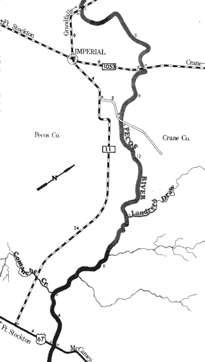
Pecos River
Farm-to-Market 11 to US Highways 67 and 385
39 Miles
Farm-to-Market 11 to US Highways 67 and 385
39 miles
This 39-mile section of the Pecos River forms the partial boundary between Crane and Pecos Counties. The river flows through semi-arid to arid ranching and farming country, and the flow of water is minimal. The river is narrow and lined with saltcedar thickets. Agricultural and oil field pollutants have reportedly caused deterioration of the water quality along this stretch. The Pecos River is the life-blood of this arid region. That is, virtually all activities in this area depend upon the Pecos for their existence. However, the river is isolated and little or no development is found along the banks. The narrow width of the stream and minimum water flow do not always provide good conditions for recreational use. However, a reasonable amount of recreational activity is possible during periods of adequate rainfall. During these periods, flash floods are a potential hazard. Waterway features and distance between each are as follows:
FM 11 crossing - 6 miles north of Imperial.
FM 1053 crossing - 6 miles northeast of
Imperial. (8 miles)
County road crossing - off FM 11, 6 miles
east of Imperial. (6 miles)
Landreth Draw - enters on the left. (12 miles)
Comanche Creek - enters on the right.
(9 miles)
US 67 & 385 crossing - 21 miles south of
Crane. (4 miles)
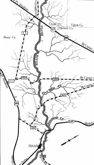
Pecos River
US Highway 67 to Farm-to-Market 1980
30 Miles
US Highway 67 to Farm-to-Market 1980
30 miles
Forming the partial boundary of Pecos, Crane, and Crockett Counties, this 30-mile section of the Pecos River flows through open ranching country and except for scattered ranching activities, relatively little development is present. This is semi-arid to arid country and desert plants like sagebrush, cacti, and yucca are the common vegetative species. The Pecos is a narrow stream at this point and has a relatively low flow of water at most times of the year. During periods of rainy weather, this section has sufficient water for recreational use; however, caution is called for during these periods as flash floods are a potential hazard. Water quality is rather poor because of agricultural and oil field pollutants. The land along the river is relatively flat and the river flows slowly between narrow banks. An occasional rapid or area of fast water exists. Waterway features and distance between each are as follows:
US 67 & 385 crossing - 30 miles northwest of
Iraan.
FM 1901 crossing - 22 miles northwest of
Iraan. (10 miles)
Five-Mile Creek - enters on the left. (5 miles)
FM 305 crossing - 14 miles northwest of Iraan.
(2 miles)
Simson Creek - enters on the left. (5 miles)
SH 349 crossing - 6 miles north of Iraan.
(1 mile)
FM 1980 crossing - 1 mile east of Iraan. (7 miles)
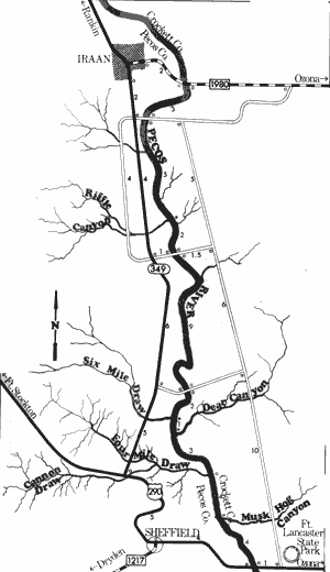
Pecos River
Farm-to-Market 1980 to US Highway 290
33 Miles
Farm-to-Market 1980 to US Highway 290
33 miles
This is a 33-mile section of the Pecos River forming the partial boundary between Pecos and Crockett Counties. The river begins to enter increasingly rugged country and numerous side canyons and creeks intersect at various points. The large bluffs and mesas located away from the river create a canyon effect. The climate is semi-arid to arid, and the water level is relatively shallow during most periods of the year. However, during rainy periods the water level is excellent for recreational use. Flash floods are not uncommon on the Pecos and extreme caution needs to be exercised during periods of heavy rains.
The riverbed itself is relatively narrow as it flows through the wide flood plain. Some very good rapids exist along this stretch, particularly at the junction of side canyons where boulders have been washed into the river by creeks. Long quiet pools exist between these rapids. Several road crossings divide this section into convenient segments for recreational use. Waterway features and distance between each are as follows:
FM 1980 - 2 miles east of Iraan.
County road crossing - off SH 349, 2 miles
south of Iraan. (3 miles)
Riffle Canyon - enters on the right. (5 miles)
County road crossing - off SH 349, 6 miles
south of Iraan. (2 miles)
County road crossing - off SH 349, 12 miles
south of Iraan. (9 miles)
Six Mile Draw - enters on the right. (2 miles)
Dear Canyon - enters on the left. (1 mile)
Four Mile Draw - enters on the right. (3 miles)
Musk Hog Canyon - enters on the left.
(4 miles)
US 290 crossing - 4 miles east of Sheffield.
(4 miles)
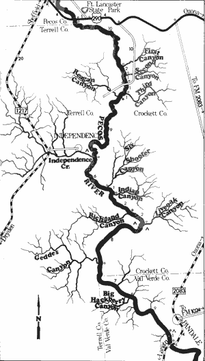
Pecos River
US Highway 290 to Pandale Crossing
64 Miles
US Highway 290 to Pandale Crossing
64 miles
This section of the Pecos River is located in Pecos, Terrell, Crockett, and Val Verde Counties. This isolated stretch is approximately 64 miles in length following through some very wild and rugged country with the land on both sides being semi-arid to arid ranchland. No development other than ranching activities exist. The Pecos River and its tributary creeks cut through this rolling terrain and form deep canyons.
The water level during normal periods is rather shallow for the first half of this section. However, from the point where Independence Creek joins the Pecos, there is usually adequate water for recreational use. During periods of heavy rainfall, flash floods frequent both the side canyons and the Pecos Canyon itself. Many rapids are found along this section, particularly at the mouths of side canyons where boulder outwashes are present. Waterway features and distance between each are as follows:
US 290 crossing - 4 miles east of Sheffield.
First Canyon - enters on the left. (10 miles)
Second Canyon - enters on the left. (2 miles)
County road crossing - off US 290, 14 miles
southeast of Sheffield. (1 mile)
Third Canyon - enters on the left. (1 mile)
Reagan Canyon - enters on the right. (1 mile)
Independence Creek - enters on the right.
(9 miles)
Private Camp - A guest ranch is located at
the mouth of Independence Creek, and
access to the river is available at this
point for a fee. Facilities for camping are
available.
Six Shooter Canyon - enters on the left.
(6 miles)
Indian Canyon - enters on the left. (1 mile)
Richland Canyon - enters on the right. A private
camp is located in this vicinity. (2 miles)
Liveoak Canyon - enters on the left. A private
camp is located in this vicinity. (2 miles)
Geddes Canyon - enters on the right. (8 miles)
Big Hackberry Canyon - enters on the right.
(7 miles)
Private Camp - on the left. (9 miles)
Pandale Crossing - FM 2083 crossing, 4 miles
south of Pandale. (3 miles)
Two additional private camps are located on
this section. Exact locations are not
available.
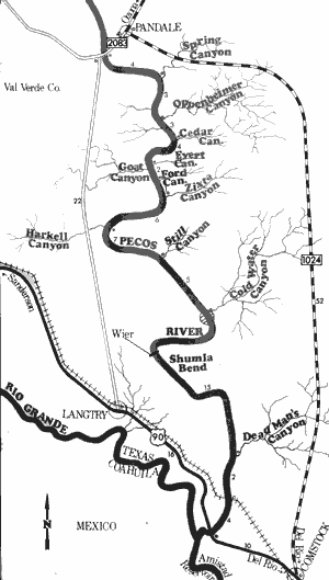
Pecos River
Pandale Crossing to US Highway 90
55 Miles
Pandale Crossing to US Highway 90
55 miles
This isolated 55-mile section of the Pecos River in Val Verde County is the best section of the entire river for recreational use. The Pecos River and its tributary creeks have worn away at the Chihuahuan Desert to form a spectacular network of canyons. These canyons progressively increase in depth downstream from the Pandale Crossing to eventually rise several hundred feet above the river in the vicinity of the US 90 high bridge.
Many rapids exist along this section, particularly at the mouths of the side canyons where outwashes of boulders and rocks have been deposited in the river by flash floods. Some of the rapids are tricky but all are negotiable. The water level during most periods of the year is shallow but sufficient water is available for recreational use at all times. During and shortly after rainy periods, this section of the Pecos has excellent water levels for recreational purposes. Flash flooding is common during heavy rains and extreme care needs to be exercised during periods when this hazard exists. A few miles upstream from the US 90 high bridge, the backwaters of Amistad Reservoir are found. The sheerest and tallest canyon walls on the Pecos are located at this point. Waterway features and distance between each are as follows:
Pandale Crossing - FM 2083 crossing, 4 miles
south of Pandale.
Spring Canyon - enters on the left. (4 miles)
Oppenheimer Canyon - enters on the left.
(3 miles)
Cedar Canyon - enters on the left. (3 miles)
Evert Canyon - enters on the left. (4 miles)
Goat Canyon - enters on the right. (0.5 mile)
Ford Canyon - enters on the left. (2 miles)
Zixta Canyon - enters on the left. (1 mile)
Harkell Canyon - enters on the right. (6 miles)
Still Canyon - enters on the left. (7 miles)
Cold Water Canyon - enters on the left. A
major rapid is located at the mouth of the
canyon. (5 miles)
Weir - a dam is located on the river, and a
portage is required.
Dead Man's Canyon - enters on the left.
(15 miles)
High Bridge - Southern Pacific Railroad bridge
is 321 feet above normal river level. (1 mile)
US 90 crossing - 10 miles west of Del Rio.
(4 miles). The old highway crossing goes
down to the river. This is the last road
crossing above Amistad Reservoir.
Top of Page | Table of Contents