- Table of Contents
- Foreword
- Introduction
- Texas Waterway Map
- Map Key
- East Texas Waterways
- Central Texas Waterways
- Major Waterways:
- Blanco River
- Bosque River
- Brazos River
- Colorado River
- Concho River
- Frio River
- Guadalupe River
- Lampasas River
- Lavaca River
- Leon River
- Little River
- Llano River
- Medina River
- Navidad River
- Nueces River
- Paluxy River
- Pedernales River
- San Antonio River
- San Bernard River
- San Gabriel River
- San Marcos River
- San Saba River
- Wichita River
- Seasonal and Restrictive Waterways
- Major Waterways:
- West Texas Waterways
An Analysis of Texas Waterways
A Report on the Physical Characteristics of Rivers, Streams, and Bayous in Texas
Major Waterways of West Texas
Rio Grande (Part One)
The Rio Grande rises in the State of Colorado, flows southward through New Mexico, then forms the International Boundary between the Mexican States of Chihuahua, Coahuila, Nuevo Leon, Tamaulipas, and the State of Texas. Its total length is approximately 1,896 miles, with approximately 1,248 miles being located along the southern border of Texas. The remoteness and scenic beauty of the lands through which it flows mark sections of the Rio Grande as possibly the only river in Texas which has potential for inclusion in the National Wild and Scenic Rivers System.
Texas-New Mexico Border to Presidio
(Not mapped)
258 miles
The Rio Grande, from El Paso downstream to Presidio, is virtually a dry riverbed because of extensive irrigation in New Mexico. However, the river becomes a permanent stream once again when the Rio Concho enters the streambed from Mexico, just upstream from Presidio-Ojinaga.
The stretch from El Paso to Presidio contains insufficient water for recreational use. The river bordering Hudspeth and Presidio Counties, particularly in the vicinity of the Quitman Mountains, is very scenic. From Presidio downstream for approximately 300 miles, the river flows through a series of some of the most rugged and spectacular canyons in the United States.
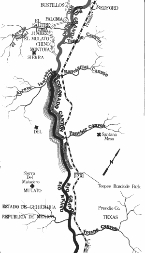
Rio Grande River
Presidio to Lajitas (Including Colorado Canyon)
50 Miles
Presidio to Lajitas (Including Colorado Canyon)
50 miles
Located in Presidio County, this section of the Rio Grande always contains sufficient water levels for recreational use. The Rio Concho joins the Rio Grande above Presidio and a healthy flow of water enters the riverbed. The river along this section follows a chain of mountains on the Mexican side. However, the Texas side between Presidio and Redford is currently being irrigated for crops. The scenery becomes increasingly rugged as the river moves downstream. This entire 50-mile section is closely paralleled by the river road, or El Camino del Rio (FM 170).
In the vicinity of and below Redford, the Rio Grande flows through rugged terrain and a series of large rapids exist. These rapids are some of the better rapids on the Rio Grande. In addition, Colorado Canyon is a short, but extremely scenic canyon which is also noted for its exciting rapids. The canyon is formed as the river flows around the bulk of Colorado Mountain. Below Colorado Canyon, the river flows through relatively flat desert terrain enroute to its rendezvous with the Mesa de Anguila and Santa Elena Canyon. Waterway features and distance between each are as follows:
US Border Port of Entry - on US 67 between Presidio and Ojinaga.
Fort Leaton State Park - The ruins of an old fortress are located adjacent to the river.
The site is now a State Historical Park. (5 miles)
Alamito Creek - enters on the left. Alamito Creek is one of the major drainages of the
Rio Grande on the United States side. (3 miles)
Torneros Creek - enters on the left. (2 miles)
Bofecillos Canyon - enters on the left. (5 miles)
Village of Redford - This small village is located along the banks of the river. (1 mile)
Tapado Canyon - enters on the left.
(10 miles)
Anvil and Davit Rocks - two distinct rock
formations located along the river. The
old river road (FM 170) passes close
to the formations. (2 miles)
Colorado Canyon - The canyon actually is
formed by Colorado Mountain and a
Mountain chain on the Mexican side
of the river. The canyon itself is
approximately 8 miles long. (2 miles)
Roadside park - located on FM 170
adjacent to the river at the downstream
end of Colorado Canyon. (8 miles)
Fresno Creek - enters on the left. (6 miles)
Contrabando Creek - enters on the left.
(1 mile)
Lajitas - a small village located outside of
the western boundary of Big Bend
National Park. A road behind the trading
post leads down to a side slough of the
river. This slough is not the main channel,
but usually contains sufficient water for
recreational use. (5 miles)
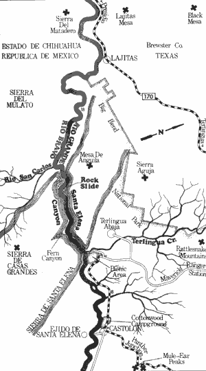
Rio Grande River
Lajitas to Castolon (Including Santa Elena Canyon)
26 Miles
Lajitas to Castolon (Including Santa Elena Canyon)
26 miles
This 26-mile section of the Rio Grande containing Santa Elena Canyon is one of the most famous and popular segments of the river. The National Park Service requires that a permit (primarily for safety purposes) be obtained before recreational use is allowed. The entire section is extremely scenic with the main feature being spectacular Santa Elena Canyon, which has been formed by the river cutting down through the Mesa de Anguila.
Recreational use of this section is possible at almost any time. However, the best conditions exist at normal or slightly above normal water levels. This section and particularly the area of the rockslide are considered extremely dangerous at high water levels. Water levels above 5 feet are considered hazardous.
The section from Lajitas to the canyon entrance flows through progressively rugged country, and many fine rapids exist. Santa Elena Canyon is extremely scenic, rising above the river approximately 1500 feet. Although the walls of the canyon rise straight up, several tall grassy banks are available for camping and day use. Most of these banks afford adequate protection from subsequent rises in water level. Below the exit of the canyon the Mesa de Anguila exists on the Mexican side, while open desert terrain is backdropped by the Chisos Mountains on the Texas side. Waterway features and distance between each are as follows:
Lajitas - a small village located outside of the western boundary of Big Bend National Park.
A road behind the trading post leads down to a side slough of the river. This slough
is not the main channel, but usually contains sufficient water for recreational use.
Conical Peak - A conical peak composed of brown igneous and white limestone rocks
is found. (6 miles)
Sentinel Peak - a second conical peak composed entirely of limestone seems to guard
the canyon entrance. Hence, the name Sentinel Peak. (5 miles)
Santa Elena Canyon Entrance - the river flows through a massive crack in the
Mesa de Anguila. (1 mile)
Mirror Canyons - two side canyons on either
side of the river appear to be identical.
These side canyons are located just
inside the entrance to Santa Elena
Canyon. (0.0 mile)
Rockslide - The rockslide is formed where
the sheer vertical wall on the Mexican
side has broken off and fallen into the
river. Large boulders virtually choke off
the river. This slide area is dangerous
even at normal water levels and it is
recommended that only experts with
experience in fast water ever attempt
to run it. Two alternatives are available
to by-pass the rockslide. One is to line
and portage down the Texas side at
normal water levels. The other alternative
for periods of high water is to portage
over the top of the slide along the
Mexican wall of the canyon. This
portage is safer but very strenuous.
(0.25 mile)
Fern Canyon - A unique side canyon on
the Mexican side containing spring-fed
pools, ferns, and crystal clear water.
(4 miles)
Cow or Sheep Cave - A large cave located
high above the river on the Mexican side.
(2 miles)
Santa Elena Canyon Exit - the canyon
abruptly ends as the river issues from
the Mesa de Anguila. (1 mile)
Terlingua Creek - located immediately
below the canyon exit. A National Park
Service campground is located at the
mouth of the creek. (0.0 mile)
Castolon - a small village located along the
river. Good access is available. (7 miles)
Castolon to Talley
(Not mapped)
40 miles
Although this section is located between two extremely scenic desert canyons, it is also a good recreational waterway. The river below Santa Elena Canyon follows the Mesa de Anguila in Mexico for several miles, then flows through relatively flat desert terrain enroute to Mariscal Canyon. Small bluffs and outcroppings of rocks prevail, and giant reeds along with typical desert plants, dominate the landscape. Here, occasional glimpses of the scenic Chisos Mountains and the mountains in Mexico can be seen. Water levels are adequate and safe at most times for recreational use. This section of the Rio Grande is an excellent recreational waterway, but the popularity of the major canyons greatly reduces the amount of usage this segment receives.
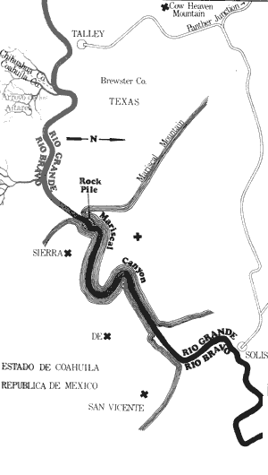
Rio Grande River
Talley to Solis (Including Mariscal Canyon)
12 Miles
Talley to Solis (Including Mariscal Canyon)
12 miles
Mariscal Canyon is a scenic desert canyon located in the southernmost part of Big Bend National Park. The canyon is formed where the Rio Grande cuts through Mariscal Mountain. With canyon walls rising to a maximum of 1800 feet in height, Mariscal Canyon is given the distinction of having the sheerest walls of any canyon on the river. This section is approximately 12 miles in length and the best water level for recreational use has been reported to be 3 feet.
Access to the river is relatively difficult, since the only road going to the canyon is an unimproved park road. Unless there have been recent heavy rains, the road is passable to passenger vehicles. Access to Mariscal Canyon is available at either Panterra or Talley upstream from the canyon and at Solis downstream. A National Park Service permit for travel over primitive roads and a campfire/boat permit is required before recreational use is possible.
The first part of this section flows through increasingly rugged desert country, and a few small rapids exist. The entrance to the canyon appears as a crack in Mariscal Mountain. Of the only two potentially hazardous places in the canyon, the first hazard is located within 100 yards of the entrance to the canyon. This is the Rockpile, a miniature version of Santa Elena Canyon's famous Rockslide. However, the Rockpile is considered passable. The second obstacle, located about one-half mile below the Rockpile, is known as the "tight squeeze". Here, a large boulder fills up the river leaving only two chutes, one about five feet wide on the left and the other about ten feet wide with a tight turn on the right. The "tight squeeze" is passable on the right.
Below the "tight squeeze" several miles of scenic canyon exists. There is a break in the middle of the canyon where the walls recede from the river for about a quarter of a mile. A dry creek enters at this point.
At one point on the Mexican side, Indian petroglyphs are etched on a boulder near the creek's mouth. An old Indian trail and some old dugouts where Mexicans often live are other points of interest. Several miles of open desert country are between the canyon exit and Solis. Waterway features and distance between each are as follows:
Talley - The road leading to Talley is a
primitive park road. A few miles before the
river is reached, the road branches. The
left road leads to Talley, the right to
Panterra.
Mariscal Canyon Entrance - The entrance
appears as a crack in Mariscal
Mountain. (1.5 miles)
Rockpile - A miniature version of Santa
Elena Canyon's Rockslide. The Rockpile
is passable but is considered angerous.
It is located just inside the entrance to
the canyon.
Tight Squeeze - Here a large boulder fills
up the river forming two constricted
channels. The right channel is passable.
(1 mile)
The Break - At this point the canyon
walls recede from the river for approximately one-fourth mile. A dry creek
enters from Mexico, and an old Indian
trail, Indian petroglyphs and some
Mexican dugouts exist. (2.5 miles)
Mariscal Canyon Exit - The river issues
from the crack in Mariscal Mountain.
(4.5 miles)
Solis - The only identifying structure is a
small cabin on the Mexican side.
Typical desert scenery is found from
the canyon exit to Solis. (2.5 miles)
Top of Page | Table of Contents