Conservation Committee
Wednesday, 9:00 am, May 27, 2009
Texas Parks and Wildlife DepartmentCommission Hearing Room
4200 Smith School Road, Austin, TX 78744
Commissioner Mark E. Bivins, Committee Chair
Scott Boruff, Committee Liaison
Approval of Previous Meeting Minutes
- Update on TPWD Progress in Implementing the TPWD Land and Water Resources Conservation and Recreation Plan
- East Texas Timberland Divestitures
- Conservation Reserve Program (CRP) Land Conversion Issues
- Status on the Update of the Texas Parks and Wildlife Department Land and Water Resources Conservation and Recreation Plan
Staff: Scott Boruff - Rate Schedule Regarding Damages to Department Properties
Staff: Scott Boruff, Ted Hollingsworth - Excavation of Archeological Site at Seminole Canyon State Park and Historic Site
Staff: Tim Roberts - Proposed Changes to the Issuance of Marl, Sand, Shell, and Gravel Permit Rules – Permission to Publish Proposed Changes in the Texas Register
Staff: Rollin MacRae - Acceptance of Land Donation – Bexar County – Approximately 3,000 Acres – Government Canyon State Natural Area (Action Item No. 12)
Staff: Ted Hollingsworth - Acceptance of Land Donation and Land Exchange from Brazos River Authority – Palo Pinto County – Approximately 700 Acres for 200 Acres of Submerged Lands at Possum Kingdom State Park (Action Item No. 13)
Staff: Ted Hollingsworth - Land Acquisition – Bandera County – 732 Acres at Lost Maples State Natural Area (Action Item No. 14)
Staff: Ted Hollingsworth - Border Fence – Update on Condemnation Litigation Against TPWD Involving 2.989 Acres at the Anacua Unit of the Las Palomas Wildlife Management Area. (Executive Session Only)
Staff: Ann Bright - Land Exchange – Galveston County – Receipt of 11 Acres in Exchange for 6 Acres – Galveston Island State Park (Executive Session and Action Item No. 10)
Staff: Corky Kuhlmann - Land Transfer – Taylor County – 91.3 Acres at Camp Tonkawa Boy Scout Camp/Abilene State Park (Executive Session and Action Item No. 11)
Staff: Corky Kuhlmann
Committee Agenda Item No. 1
Presenter: Carter Smith
Conservation Committee
Update on TPWD Progress in Implementing the
TPWD Land and Water Resources Conservation and Recreation Plan
May 27, 2009
I. Executive Summary: Executive Director Carter Smith will briefly update the Commission on the status of the agency's efforts to implement the Land and Water Resources Conservation and Recreation Plan (the Plan).
II. Discussion: In 2001, the 77th Texas Legislature directed that the Texas Parks and Wildlife Department (TPWD) develop a Land and Water Resources Conservation and Recreation Plan (Tex. Park & Wild. Code §11.104). In November 2002, the Texas Parks and Wildlife Commission (the Commission) adopted the first Plan. A revised Plan was adopted by the Commission in January 2005. The Plan is available on the TPWD web site. Executive Director Carter Smith will update the Conservation Committee on TPWD's recent progress in achieving the Plan's Goals and Objectives as they relate to the Conservation Committee.
The Plan consists of 8 Goals and a total of 56 Objectives. The Goals stated in the Plan are as follows:
- Goal 1: Improve access to the outdoors.
- Goal 2: Preserve, conserve, manage, operate, and promote agency sites for recreational opportunities, biodiversity, and the cultural heritage of Texas.
- Goal 3: Assist landowners in managing their lands for sustainable wildlife habitat consistent with their goals.
- Goal 4: Increase participation in hunting, fishing, boating and outdoor recreation.
- Goal 5: Enhance the quality of hunting, fishing, boating and outdoor recreation.
- Goal 6: Improve science, data collection and information dissemination to make informed management decisions.
- Goal 7: Maintain or improve water quality and quantity to support the needs of fish, wildlife and recreation.
- Goal 8: Continuously improve TPWD business management systems, business practices and work culture.
Committee Agenda Item No. 2
Presenter: Scott Boruff
Conservation Committee
Status on the Update of the Texas Parks and Wildlife Department
Land and Water Resources Conservation and Recreation Plan
May 27, 2009
I. Executive Summary: Staff will update the Texas Parks and Wildlife Commission on the status and schedule for writing and publishing the updated Texas Parks and Wildlife Department Land and Water Resources Conservation and Recreation Plan (Land and Water Plan) in December 2009.
II. Discussion: In December 2008, Texas Parks and Wildlife Department (TPWD) staff organized the state into twelve watershed-based strategic planning regions and organized Texas Conservation and Recreation Forums (TxCRF) in each region. Consisting of inter-divisional TPWD staff and external conservation stakeholders, each TxCRF meets regularly to discuss regional conservation priorities and strategies. The first task of these forums has been to provide input to TPWD for the updating of the Land and Water Plan. As of May 2009, each forum has met, with several forums having conducted multiple meetings. More than 100 organizations and 3,000 individuals have been contacted. As a result of the recommendations provided by these forums, staff has recommended a reorganization of the Land and Water Plan intended to simplify the plan, make it easier to read and use, and tying it more directly to the day-to-day operations of staff. For example, the eight goals found in the 2005 edition of the plan may be consolidated into fewer goals. Staff also reviewed strategic conservation plans from a number of other states, and recommends Texas adopt a format similar to that found in the state of Missouri's plan.
A web site is being developed that includes the latest information on the forums, and the Land and Water Plan updating process and schedule. The web site will provide a vehicle for public comment on the draft plan beginning in July. A statewide series of public meetings is scheduled beginning in late July and running through early September. A final plan will be presented to the Texas Parks and Wildlife Commission for adoption.
Committee Agenda Item No. 3
Presenters: Scott Boruff
Ted Hollingsworth
Conservation Committee
Rate Schedule Regarding Damages to Department Properties
May 27, 2009
I. Executive Summary: Staff proposes to simplify negotiation of damages and fees for use of Texas Parks and Wildlife Department (TPWD) lands resulting from mineral activities, utility easements, pipelines and other uses of the surface by third parties, by adoption of a standardized damage and fee schedule.
II. Discussion: The size and location of TPWD lands, especially State Park (SP) and Wildlife Management Area (WMA) lands, regularly places them in the path of proposed seismic, mineral recovery, pipeline, utility, and other infrastructure projects. In cases where there is no reasonable and prudent alternative to the use of TPWD lands, staff negotiates with applicants for damages associated with initial project impacts, and fees for continuing occupancy of the land. These negotiations can be contentious and time-consuming, especially in the absence of a standardized fee schedule.
Under Parks and Wildlife Code §11.071, the TPW Commission has the authority to “regulate the use of department lands for oil, gas and other mineral recovery and associated activities.” Furthermore, under §13.001, the TPW Commission “shall have the exclusive authority to determine sound biological management practices for all lands under its control.” Based on these authorities, the TPW Commission may adopt guidelines, policies or rules establishing damage and fee schedules to compensate for impacts to TPWD lands by third parties. The adoption of rules would require appropriate publication in the Texas Register for public comment, but would result in a more enforceable rate schedule.
Staff seeks guidance from the Commission regarding proposed damage and fee schedules, and whether or not the Commission would direct staff to implement these schedules as TPWD Policy or initiate the process of adoption as rules.
Committee Agenda Item No. 4
Presenter: Tim Roberts
Conservation Committee
Excavation of Archeological Site at Seminole Canyon State Park and Historic Site
May 27, 2009
I. Executive Summary: Recent archeological excavations by TPWD staff and volunteers at a burned rock midden in Seminole Canyon State Park and Historic Site offers a unique opportunity to interpret the activities of the prehistoric inhabitants of this area that took place away from the much more visible and widely publicized rock shelters. The site sits at the top of the canyon rather than down in the shelters within the canyon, and could be interpreted as a summer kitchen of sorts for the inhabitants of the nearby rock shelters. The burned rock middens at this site represent the remnants of earth ovens that were used to roast various foods, but probably primarily sotol and lechuguilla.
II. Discussion: Excavations conducted by members of the TPWD cultural resources program and volunteers at the archeological site, a Late Archaic and Late Prehistoric upland burned rock midden site at Seminole Canyon State Park and Historic Site, Val Verde County, revealed two burned rock middens dating to the Late Archaic and Late Prehistoric periods. These middens represent the remnants of earth ovens that appear to have been used periodically over the course of approximately 1,200 years. The chipped stone artifact assemblage discovered in association with the middens includes numerous scrapers, and knives associated with the harvesting, processing, and cooking of sotol or lechuguilla.
A total of 11 projectile points, spanning the Late Archaic and Late Prehistoric periods and representing the transition from atlatl hunting technology to bow and arrow technology, were discovered during the present excavations. However, no animal bones or evidence of butchering was identified at this site. Instead, it appears that the projectile points were perhaps manufactured or sharpened at this site for use elsewhere.
The recovery of several mussel shells from the Rio Grande, located about three miles south of the site, indicates that mussels were part of the diet of the hunter-gatherer occupants of this site, also known as the Lost Midden site.
Perhaps as interesting as the archeology at this site, is the setting within which it was discovered. While evidence of most upland archeological sites can be observed on the ground surface, the present site was buried within a sediment-filled basin. While geomorphological analyses are continuing, it appears that this basin may represent the early stages of a sinkhole beginning to form. Although the basin was largely filled with sediments prior to the creation of the earth ovens in this area, prehistoric inhabitants may have recognized a difference in vegetation in this area due to increased moisture being trapped within the underlying basin. Whatever the initial attraction, the prehistoric inhabitants made use of this rare occurrence of thick soil deposits to dig pits for their earth ovens.
An interpretive brochure about prehistoric earth oven technology, with specific reference to archeological discoveries at this site, has been created for distribution at Seminole Canyon State Park and Historic Site, and other publication venues are being explored. A technical report is also being prepared, and a paper on the results of the excavation will be presented at the Texas Archeological Society's Annual Meeting in Del Rio in October 2009.
Attachments - 2
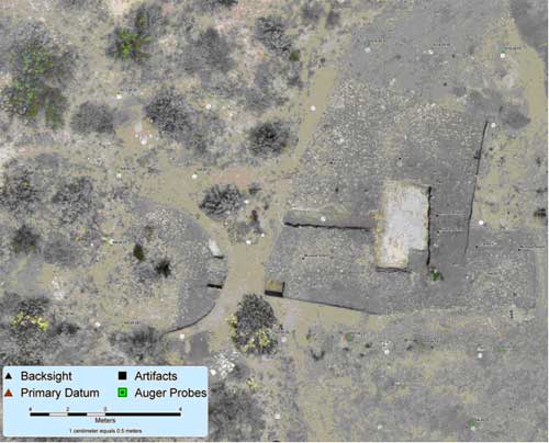
- Exhibit A – Aerial photograph of archeological site
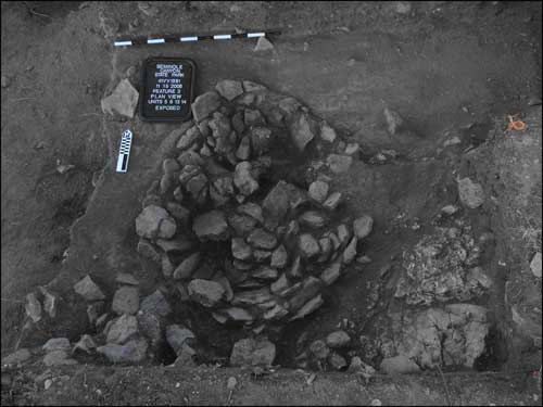
- Exhibit B – Photograph looking down onto intact earth oven feature
Committee Agenda Item No. 4
Exhibit A
Aerial photograph of archeological site, Seminole Canyon State Park and Historic Site, showing the distribution of the burned rock middens.
Committee Agenda Item No. 4
Exhibit B
Photograph looking down onto intact earth oven feature at archeological site, Seminole Canyon State Park and Historic Site, Val Verde County.
Committee Agenda Item No. 5
Presenter: Rollin MacRae
Proposed Changes to the Issuance of Marl, Sand, Shell,
and Gravel Permits
May 27, 2009
I. Executive Summary: Staff will brief the Commission on proposed amendments to the rules governing issuance of Marl, Sand, Shell, and Gravel permits. The proposed amendments to 31 Texas Administrative Code §69, Subchapter H would streamline and improve public notice provisions and clarify the conditions of permits.
II. Discussion: The public notice provisions of permit issuance are outdated not having been substantially revised in 25 years. Currently, permit issuance procedures require the posting of notices in local newspapers and the Texas Register. These requirements have proven to be time consuming, expensive, and ineffective. Procedures also require that persons directly affected in the local area receive mailed notification, and these typically result in public response. Staff proposes to replace the use of newspaper and Texas Register notice by webpage publication and email notices, which will reduce applicant cost and staff time, and improve public awareness. Likewise, pricing and payment rules have not been revised in 12 years and should be adjusted to assure that the Department receives fair value for materials extracted from areas under Commission control. Therefore, staff requests permission from the Commission to publish the following proposed changes to the Marl, Sand, Shell, and Gravel permit rules in the Texas Register for public comment.
- Changes proposed to Section 69.105 would eliminate the requirements for publication in the Texas Register and newspapers, and implement notice by electronic media.
- Changes proposed to Section 69.108 would delete the requirement for erosion and sediment studies, which the Commission had done on the most affected area on the Brazos River in 1998-2000, and which conclusively found none of the impacts postulated.
- Changes proposed to section 69.115 reduce the maximum for general permits from 1000 cubic yards to 100 cubic yards. General permits were intended to cover small projects, especially infrastructure such as pipelines. The 1000 cubic yard limit was a back-fit number from the initial application fee, and was not intended to express intent to allow that amount. The 1000 yard limit implies an inappropriate expectation of allowable disturbance.
- Changes proposed to Section 69.117 correct the time limit for processing general permits to allow staff time to incorporate comments received into the permit, and to replace publication in a newspaper with electronic media notification and mailed notice to adjacent properties.
- Changes proposed to Section 69.119 update the application fee for general permits from $250 to $500 to better reflect costs of staff effort in reviewing and issuing permits.
- Changes to section 69.121 adjust the price charged for sand and gravel mined from state rivers. The present fee has a minimum royalty of $0.20 per ton or 8 percent of the selling price, whichever is higher. The change would raise the minimum to $0.50 per ton or 10 percent of the selling price. (Recent payments at the 8 percent level are in the range of $0.40 to $0.50.)
Committee Agenda Item No. 9
Presenter: Ann Bright
Conservation Committee
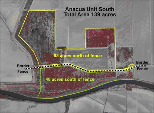
Border Fence
Update on Condemnation Litigation against TPWD Involving 2.989 Acres at the
Anacua Unit of the Las Palomas Wildlife Management Area
May 27, 2009
I. Executive Summary: Staff will brief the Commission on litigation initiated by the federal government against the Texas Parks and Wildlife Department (TPWD) to condemn 2.989 acres at the Anacua Unit of the Las Palomas Wildlife Management Area (the Anacua Unit) for the construction of tactical infrastructure, commonly known as the border fence.
II. Discussion: The federal government is constructing the border fence roughly parallel to the Rio Grande through several South Texas counties. The border fence passes through the Anacua Unit. In July, 2008, the TPW Commission voted in public session not to negotiate a settlement offer for the voluntary transfer of land within the Anacua Unit to the federal government for construction of the fence. On August 25, 2008, the federal government filed a condemnation action against TPWD in the U.S. District Court for the Southern District of Texas, Brownsville Division. On December 17, 2008, U.S. District Judge Andrew Hanen ordered the transfer of possession of 2.989 acres within the Anacua Unit to the federal government. As a result of the condemnation action and transfer of possession, the federal government now has title to 2.989 acres within the Anacua Unit. The only remaining issue in the litigation is the amount and type of compensation to be paid by the federal government to TPWD. Proceedings in the litigation have been temporarily stayed while TPWD and the federal government discuss settlement options.
Attachments - 3
Committee Agenda Item No. 9
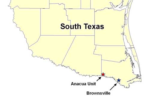
Exhibit A
Location of Anacua Unit – Lower Rio Grande Valley
Committee Agenda Item No. 9
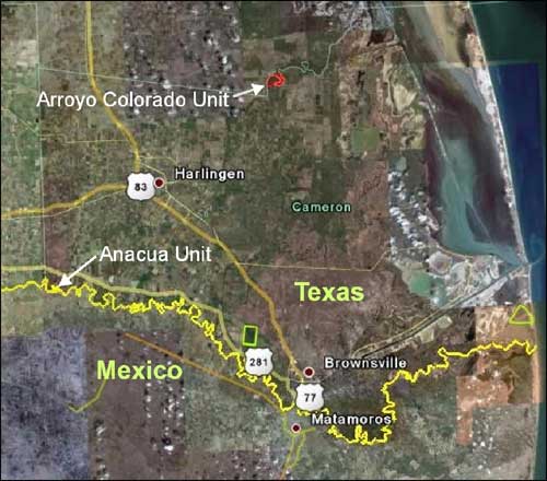
Exhibit B
Vicinity Map
Committee Agenda Item No. 9
Exhibit C
Vicinity Map
Top of Page^