Conservation Committee
Wednesday, January 25, 2012
9:00 a.m.
Texas Parks and Wildlife Department
Commission Hearing Room
4200 Smith School Road, Austin, TX 78744
Chairman T. Dan Friedkin, Committee Chair
Scott Boruff, Committee Liaison
Approval of Previous Meeting Minutes
- Update on TPWD Progress in Implementing the TPWD Land and Water Resources Conservation and Recreation Plan
Staff: Carter Smith - Edwards Aquifer Recovery Implementation Program (RIP) and Designation of a State Scientific Area – Request Permission to Publish Proposed Rules in the Texas Register
Staff: Cindy Loeffler, Colette Barron Bradsby - Proposed Land Sale – Randall and Armstrong Counties – Sale of Approximately 2,014 Acres at Palo Duro Canyon State Park – Request Permission to begin the Public Notice and Input Process
Staff: Ted Hollingsworth - Request for Storage Lease – Anderson County–Natural Gas Storage Lease at Gus Engeling Wildlife Management Area (Action Item No. 3)
Staff: Ted Hollingsworth - Land Donation – Galveston County – Approximately 47 Acres at Galveston Island State Park (Action Item No. 4)
Staff: Corky Kuhlmann - Request for Utility Easement – Hall County – Transmission Line from TUCO to Wheeler – Caprock Canyon Trailway (Executive Session)
Staff: Ted Hollingsworth - Briefing regarding Water Distribution Pipeline Easement at Monahans Sandhills State Park – Ward and Winkler Counties (Executive Session)
Staff: Ted Hollingsworth
Committee Agenda Item No. 1
Presenter: Carter Smith
Conservation Committee
Update on TPWD Progress in Implementing the
TPWD Land and Water Resources Conservation and Recreation Plan
January 25, 2012
I. Executive Summary: Executive Director Carter Smith will briefly update the Commission on the status of the agency’s efforts to implement the Land and Water Resources Conservation and Recreation Plan (the “Plan”).
II. Discussion: In 2001, the 77th Texas Legislature directed that the Texas Parks and Wildlife Department (TPWD) develop a Land and Water Resources Conservation and Recreation Plan (Tex. Park & Wild. Code §11.104). In 2002, the Texas Parks and Wildlife Commission (the Commission) adopted the first Plan. A revised Plan was adopted by the Commission in January 2005. In November 2009, the Commission approved a new Plan effective January 1, 2010. The 2010 Plan is available on the TPWD web site. Executive Director Carter Smith will update the Conservation Committee on TPWD’s recent progress in achieving the Plan’s goals, objectives and deliverables as they relate to the Conservation Committee.
The Plan consists of the following four goals:
- Practice, Encourage and Enable Science-based Stewardship of Natural and Cultural Resources
- Increase Access To and Participation In the Outdoors
- Educate, Inform and Engage Texas Citizens in Support of Conservation and Recreation
- Employ Efficient, Sustainable and Sound Business Practices
Committee Agenda Item No. 2
Presenters: Cindy Loeffler
Colette Barron Bradsby
Conservation Committee
Edwards Aquifer Recovery Implementation Program (EARIP) and Designation of a
State Scientific Area — Request to Publish Proposed Rules in the Texas Register
January 25, 2012
I. Executive Summary: The Edwards Aquifer Recovery Implementation Program (EARIP) is an open, voluntary, collaborative, consensus-based stakeholder process with a goal to help recover federally listed threatened and endangered species that depend on the Edwards Aquifer. The EARIP was initiated by the USFWS in 2006, and modified in 2007 to meet Senate Bill 3 State of Texas requirements. TPWD participation in the EARIP is extensive with participation from the Legal Division, Coastal Fisheries Division, Inland Fisheries Division and the Wildlife Division. The final product of the EARIP will be a plan to protect the federally listed endangered or threatened species while managing the use of the Edwards Aquifer. For the past four years the EARIP has been working to reach consensus on a set of strategies for protecting spring flows, especially during extreme drought periods. This plan is to be completed by September 1, 2012.
II. Discussion: The set of strategies for protecting spring flows has been coined the “Bottom Up” approach because it sets forth an incremental, phased approach to reduce aquifer pumping, increase ecosystem restoration measures and to monitor progress of these actions. Key measures included in the “Bottom Up” approach for reducing aquifer pumping include increased conservation by smaller communities, an innovation called Aquifer Storage and Recovery (ASR), voluntary suspension of irrigation pumping during drought and additional mandatory Critical Period pumping restrictions. Ecosystem restoration measures include habitat restoration, exotic species management and recreation management.
Designation of a State Scientific Area in the San Marcos River is proposed for addressing recreational impacts to Texas wild-rice. Since the San Marcos River is also a popular recreation destination, species protection must be balanced with the needs of recreational users. The City of San Marcos and Texas State University support the TPWD State Scientific Area designation as a tool to achieve the necessary balance. The proposed TPWD rule would designate the San Marcos River from Spring Lake Dam to the San Marcos Waste Water Treatment Plant as a State Scientific Area and would prohibit uprooting of Texas wild-rice. A public awareness campaign would be conducted and river access sites will be developed to maximize recreational opportunities and minimize the potential to harm the endangered plant. Staff has met with representatives of the City of San Marcos, Texas State University and others to gather input regarding the proposed rule. Public input has also been gathered during public meetings and from the TPWD website. Staff requests permission to publish proposed rules in the Texas Register.
Attachments – 1
Committee Agenda Item No. 2
Exhibit A
SAN MARCOS RIVER STATE SCIENTIFIC AREA RULE
PROPOSAL PREAMBLE
1. Introduction.
The Texas Parks and Wildlife Department (TPWD) proposes new §57.910, concerning the San Marcos River State Scientific Area (SMRSSA). The intent of the proposed new rule is to offer additional protection to Texas wild-rice (Zizania texana). The San Marcos River in Hays County is home to the world’s only naturally occurring populations of Texas wild-rice (Zizania texana), which are located primarily along a two-mile stretch of the headwaters of the San Marcos River adjacent to the City of San Marcos and the main campus of Texas State University. Texas wild-rice is habitat-specific, requiring complete submergence in a minimum of one foot of clear, clean, flowing water in order to survive and remain viable. Construction activities, urbanization and increased water-related recreational activities in the San Marcos River have increased the risk potential for wild-rice populations, mainly as a result of physical disturbance, exacerbated during drought-induced low-flow conditions when reduced water depths bring humans and animals into very close proximity with wild-rice plants that are already under stress.
In 1978, Texas wild-rice was listed by the US Fish and Wildlife Service as an endangered species and therefore is protected under federal law. However, in 2007 the Texas Legislature enacted Senate Bill 3, which required the Edwards Aquifer Authority, the groundwater district that manages and regulates the San Antonio segment of the Edwards Aquifer, to cooperate with the Texas Commission on Environmental Quality, the Texas Parks and Wildlife Department, the Texas Department of Agriculture, the Texas Water Development Board, and other stakeholders to develop a recovery implementation program with the U.S. Fish and Wildlife Service for species associated with the aquifer that are listed as threatened or endangered under federal law. As a consequence, the Edwards Aquifer Recovery Implementation Plan (EARIP) has been developed and adopted, a component of which is a Habitat Conservation Plan (HCP) to protect those species that depend on a healthy aquatic ecosystem for survival. The designation of the SMRSSA is a mechanism within the HCP for offering additional protection for the remaining populations of Texas wild-rice, and was developed by the department in cooperation with the City of San Marcos, Texas State University, the Edwards Aquifer Authority, and many other stakeholders on the EARIP.
The proposed new rule would designate an approximately two-mile segment of the San Marcos River in Hays County as a state scientific area, within which it would be unlawful to uproot wild-rice. In addition, the proposed new rule would allow the designation of restricted areas of the river associated with Texas wild-rice stands that would be temporarily off-limits to entry when the river’s streamflow falls below 120 cfs (cubic feet per second). The 120 cfs limit was developed by the Chief Science Officer at the River Systems Institute at Texas State University in consultation with the City of San Marcos and other resource managers. The U.S. Fish and Wildlife Service has established a minimum flow of 100 cfs as the trigger for federal actions to protect habitat of the various threatened and endangered species in the San Marcos river system. By establishing a threshold that is slightly higher than the 100 cfs trigger, the department intends to afford protection to wild-rice populations when environmental conditions are approaching, but not at, absolute critical levels that would trigger federal actions. The department and other cooperators will clearly mark restricted areas with equipment such as booms or buoys, will install signage at river access points to inform the public, and will conduct extensive public education and outreach efforts to ensure that to the greatest extent possible the recreational public is made aware of regulations to protect wild-rice populations. The proposed new rule affects only activities in public waters and does not affect the use of any private property. When conditions necessitate the temporary designation of restricted areas, the river will not at any point within the area be completely blocked to public access or use.
2. Fiscal Note.
Ms. Cindy Loeffler, Water Resources Branch Chief, has determined that for each of the first five years that the proposed new rule is in effect there will be no fiscal implications for the department as a result of enforcing or administering proposed new rule. There could be minimal fiscal implications to other units of state and local governments related to implementation costs; however, there is no prearranged commitment on the part of any entity to contribute any specific amount to implementation, nor is such a commitment required by the proposed new rule.
3. Public Benefit/Cost Note.
Ms. Loeffler also has determined that for each of the first five years that the proposed new rule is in effect:
(A) The public benefit anticipated as a result of enforcing or administering the proposed new rule will be the protection of an important ecosystem enjoyed by the public. Compliance with the EARIP Habitat Conservation Plan will also ensure local control of the Edwards Aquifer as a public water source
(B) Under the provisions of Government Code, Chapter 2006, a state agency must prepare an economic impact statement and a regulatory flexibility analysis for a rule that may have an adverse economic effect affect on small businesses and micro-businesses. As required by Government Code, §2006.002(g), the Office of the Attorney General has prepared guidelines to assist state agencies in determining a proposed rule’s potential adverse economic impact on small businesses. Those guidelines state that an agency need only consider a proposed rule’s “direct adverse economic impacts” to small businesses and micro-businesses to determine if any further analysis is required. For that purpose, the department considers “direct economic impact” to mean a requirement that would directly impose recordkeeping or reporting requirements; impose taxes or fees; result in lost sales or profits; adversely affect market competition; or require the purchase or modification of equipment or services. The department has determined that there will be no adverse economic impacts on small businesses or microbusinesses as a result of the proposed new rule, since it does not directly regulate any businesses and does not prohibit river access or use, only the specific acts of uprooting wild-rice or entering a restricted area of the river when such entry is prohibited. Accordingly, the department has not prepared a regulatory flexibility analysis under Government Code, Chapter 2006.
The proposed new rule will not result in negative economic impacts to persons required to comply, since the rule prohibits only the uprooting of wild-rice and entry into restricted areas at certain times. The activities that may be most impacted by the proposed rule are recreational activities. However, even recreational activities will not be completely prohibited since the proposed rule will not completely block access or public use of the river.
(C) The department has not drafted a local employment impact statement under the Administrative Procedures Act, §2001.022, as the agency has determined that the rule as proposed will not impact local economies.
(D) The department has determined that Government Code, §2001.0225 (Regulatory Analysis of Major Environmental Rules), does not apply to the proposed rule.
(E) The department has determined that there will not be a taking of private real property, as defined by Government Code, Chapter 2007, as a result of the proposed rule, as the rule would not affect private real property.
4. Request for Public Comment.
Comments on the proposed new rule may be submitted to Cindy Loeffler, Texas Parks and Wildlife Department, 4200 Smith School Road, Austin, Texas 78744; (512) 389-8715; e-mail: cindy.loeffler@tpwd.state.tx.us.
5. Statutory Authority.
The new rule is proposed under Parks and Wildlife Code, §81.501, which authorizes the commission to create state scientific areas for the purposes of education, scientific research, and preservation of flora and fauna of scientific or educational value; §13.101, which authorizes the commission to promulgate regulations, governing the health, safety, and protection of persons and property in state scientific areas, including regulations governing the conservation of natural features and destructive conduct; and §88.006, which authorizes the department to adopt regulations governing the provisions of Chapter 88, which governs endangered plants.
The proposed new rule affects Parks and Wildlife Code, Chapter 13, Subchapter B; Chapter 81, Subchapter F; and, Chapter 88.
§57.910. San Marcos River State Scientific Area.
(a) Purpose. The San Marcos River State Scientific Area is established for the purpose of education, scientific research, and preservation of flora and fauna of scientific or educational value, specifically, the preservation of Texas wild-rice (Zizania texana).
(b) Boundaries. The San Marcos State Scientific Area consists of the public waters of the San Marcos River from midstream to the boundary of public waters in the area within the following boundaries:
(1) 29 53 26.04 Lat N, 97 55 55.29 Long W (northeast boundary near Spring Lake Dam);
(2) 29 53 22.71 Lat N, 97 56 19.01 Long W (southeast boundary near the San Marcos Water Treatment Plant);
(3) 29 51 52.63 Lat N, 97 55 56.07 Long W (southwest boundary near the San Marcos Water Treatment Plant); and
(4) 29 51 53.92 Lat N, 97 55 31.94 Long W (northwest boundary near Spring Lake Dam).
(c) Restricted Areas. When the streamflow of the San Marcos River is measured at 120 cubic feet per second at the San Marcos River gaging station (United States Geological Survey gage 081705000 San Marcos River at San Marcos), the department may restrict areas by means of clearly marked booms, buoys, and/or signage to reflect the fact that the area is restricted to unauthorized entry.
(d) Prohibited Acts. It is an offense for any person to:
(1) move, remove, deface, alter, or destroy any sign, buoy, boom, or other such marking delineating the boundaries of the San Marcos River State Scientific Area or a restricted area within the area;
(2) uproot Texas wild-rice within the San Marcos State Scientific Area;
(3) enter an area that is marked by signage, booms, buoys, or other apparatus clearly identifying the area as a restricted area, except as may be permitted by the department or the U.S. Fish and Wildlife Service;.
(e) Penalties. The penalty for violation of this section is prescribed by Parks and Wildlife Code, §13.112.
This agency hereby certifies that the proposal has been reviewed by legal counsel and found to be within the agency’s authority to adopt.
Issued in Austin, Texas, on
Committee Agenda Item No. 3
Presenter: Ted Hollingsworth
Conservation Committee
Proposed Land Sale – Randall and Armstrong Counties
Sale of Approximately 2,014 Acres at Palo Duro Canyon State Park
January 25, 2012
I. Executive Summary: TPWD has received contract offers for the purchase of a portion of the Fortress Cliffs Ranch at Palo Duro Canyon State Park.
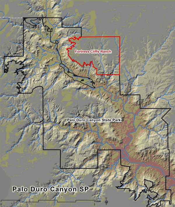
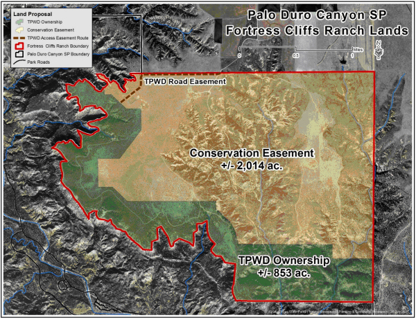
II. Discussion: In 2008, in a dual transaction straddling FY2008 and FY2009, Texas Parks and Wildlife Department (TPWD) acquired the 2867-acre Fortress Cliffs Ranch in order to protect the 5-mile face and rim of Fortress Cliffs, which dominate much of the viewshed from the state park within the canyon. The ranch was on the market and facing the prospect of being broken into small canyon-front home lots, which could have severely compromised the aesthetics of the park.
The acquisition included a house valued approximately $1 million, and roughly 1,500 acres of grassland used as pasture by previous owners, neither of which were considered to add significantly to the mission of the park. At the time of acquisition, it was intended that these assets would be evaluated and the portion of the ranch with minimal value to TPWD would be sold. Using computer modeling and site visits to map views from the park, evaluate recreational access and outline public use options, staff proposed the sale of the house and approximately 2,014 acres of land, primarily grassland with some cedar brush and a side canyon complex known as Tubbs Draw. The sale tract is configured to include a quarter mile of canyon rim, to maximize its attractiveness to potential buyers. The entire sale tract will be restricted by a conservation easement held by TPWD. The property can only be subdivided into two tracts in the future, no development can occur near the rim, and the terms of the easement will run with the land in perpetuity.
A local broker was retained and public marketing of the tract began in December 2010. An offer for purchase has been presented to TPWD consisting of terms and conditions staff believes to be in the best interest of TPWD. Staff requests permission to begin the public notice and input process.
Committee Agenda Item No. 3
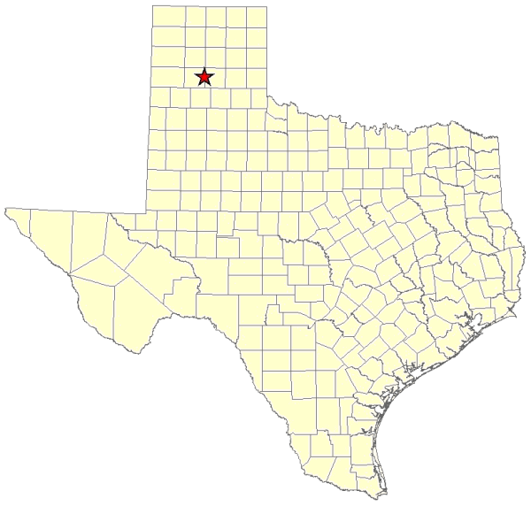
Exhibit A
Location Map for Palo Duro Canyon State Park – Randall and Armstrong Counties
Committee Agenda Item No. 3
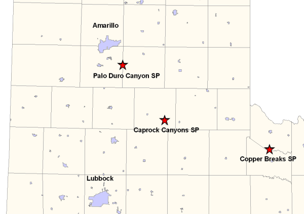
Exhibit B
Vicinity Map for Palo Duro Canyon State Park
Committee Agenda Item No. 3
Exhibit C
Palo Duro Canyon SP Map Showing the Fortress Cliffs Ranch
Committee Agenda Item No. 3
Exhibit D
Site Map of Fortress Cliffs Ranch
Committee Agenda Item No. 6
Presenters: Ted Hollingsworth
Conservation Committee
Request for Utility Easement—Caprock Canyon Trailway
TUCO to Wheeler Transmission Line—Hall County
January 25, 2012
I. Executive Summary: Southwestern Public Service Company requests the Texas Parks and Wildlife Commission grant an easement for the proposed crossing of the Caprock Canyons Trailway by an electric transmission line.
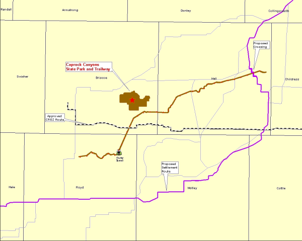
II. Discussion: Southwestern Public Service (SPS) has filed an application with the Public Utility Commission (PUC) to amend SPS’s Certificate of Convenience and Necessity (CCN) for a proposed 345 kV transmission line from the TUCO substation to Wheeler (PUC Docket No. 38877). The proposed transmission line will or may run through Hale, Floyd, Motley, Cottle, Briscoe, Hall, Childress, Donley, Collingsworth, and Wheeler Counties. TPWD staff have intervened and participated in this CCN matter. One of the preferred routes would cross the Caprock Canyon Trailway. Southwestern Public Service has requested that TPWD grant an easement for crossing the Caprock Canyons Trailway in Hall County. Staff will brief and seek input from the Commission regarding the negotiation of this easement and may seek permission to begin the public notice and input process.
Committee Agenda Item No. 6
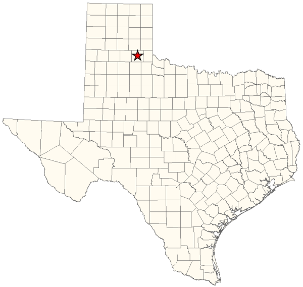
Exhibit A
Location Map for Hall County
Committee Agenda Item No. 6
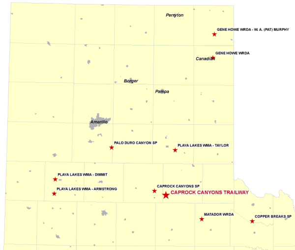
Exhibit B
Vicinity Map for Caprock Canyon Trailway
Committee Agenda Item No. 7
Presenter: Ted Hollingsworth
Conservation Committee
Water Distribution Pipeline Easement at Monahans Sandhills State Park
January 25, 2012
I. Executive Summary: The Colorado River Municipal Water District has responded to terms and conditions of a draft lease authorized by the TPW Commission in November 2011.
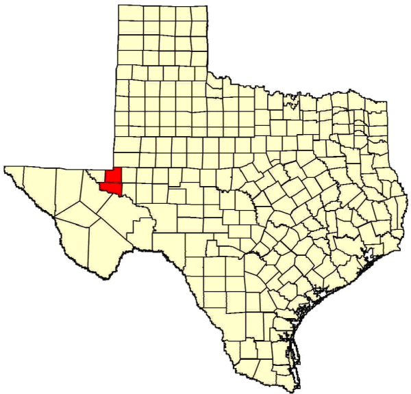
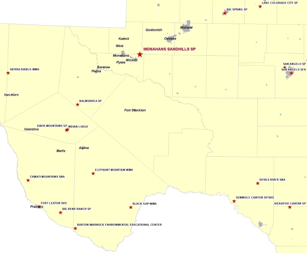
II. Discussion: Monahans Sandhills State Park (SP) covers 3,840 acres straddling Ward and Winkler counties southwest of Odessa. As the name implies, the park preserves an excellent example of arid land sand dunes, some up to 70 feet high. The site protects a range of resources such as an important archeological site and the Dunes sagebrush lizard, a candidate species for federal listing.
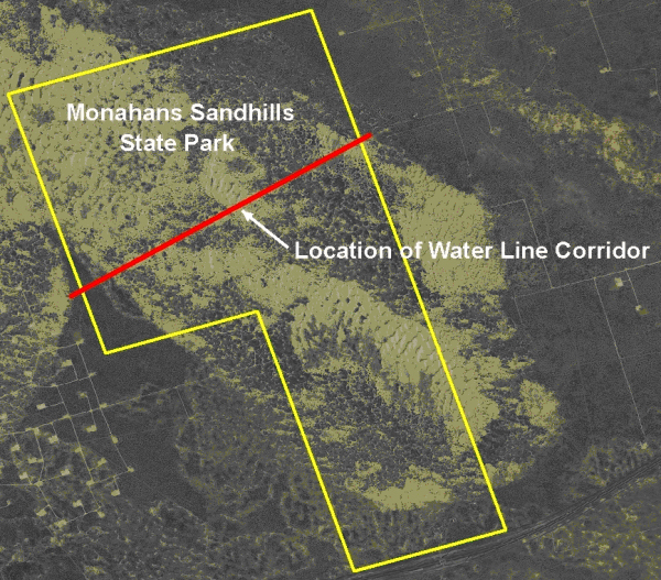
The park has been managed and operated since 1956 under a long-term lease from the Sealy and Smith Foundation (Foundation) of Galveston. In 1971 the Colorado River Municipal Water District (CRMWD) obtained an easement from the Foundation and installed a 33-inch waterline through the state park in Ward County. The CRMWD supplies water to Odessa, Snyder and Big Spring. Due to growth in these communities since 1971, and the strain on water supplies precipitated by the current drought, CRMWD wishes to install a second pipeline of 48 inches parallel to the existing line. They would like to begin construction in January 2012.
In November 2011, the TPW Commission passed a resolution authorizing the Executive Director “to take all necessary steps to negotiate terms and conditions under which TPWD concurs with the granting of an Easement, and to provide those terms and conditions to the Foundation with a recommendation that an Easement be granted to CRMWD for the purposes and subject to the conditions described herein and in the motion approved in this Resolution.” Land Conservation and Legal staff will brief and discuss with the Commission in Executive Session the real estate and legal issues associated with this matter.
Attachments — 3
Committee Agenda Item No. 7
Exhibit A
Location Map for Monahans Sandhills SP in Ward and Winkler Counties
Committee Agenda Item No. 7
Exhibit B
Vicinity Map for Monahans Sandhills SP 30 miles Southwest of Odessa
Committee Agenda Item No. 7
Exhibit C
Site Map for Requested Easement at Monahans Sandhills SP
