Commission Agenda Item No. 9
Presenter:
Ted Hollingsworth
Action
Acceptance of Donation of Land – Matagorda County
Approximately 172 Acres at the Matagorda Peninsula Coastal Management Area
January 23, 2020
I. Executive Summary: The Texas Parks and Wildlife Department (TPWD) has been offered approximately 172 acres of land on Matagorda Peninsula for addition to the Matagorda Peninsula Coastal Management Area (CMA).
II. Discussion: In 2017, TPWD established the Matagorda Peninsula CMA with the acquisition of 5,402 acres of land on Matagorda Peninsula from the Texas General Land Office (GLO). The CMA currently preserves approximately 12 miles of peninsula from the original Brown Cedar Cut westward and from the Gulf of Mexico to East Matagorda Bay. This is a remote and undeveloped barrier system that preserves habitat for a remarkable diversity of coastal wildlife from nesting sea turtles to resident and migratory shore and wading birds, several of which are listed as species of greatest conservation need. Habitat present at the CMA consists of Gulf beaches, sand dunes, lagoons, strand prairies, bayous, tidal flats, and emergent salt marshes that are critical for the production of crustaceans, shellfish, and finfish. The East Matagorda Bay system has been identified as a conservation focal area by TPWD and its conservation partners. Goals to protect the East Matagorda Bay system include the conservation of as much of the peninsula and surrounding bay shoreline as opportunities and funding allow.
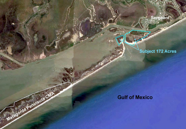
The owners of approximately 172 acres of land that straddle the current Brown Cedar Cut at the northeast end of the CMA project area have offered to donate their land to TPWD for addition to the CMA. The tract includes three-fourths of a mile of frontage on the Gulf Intracoastal Waterway, uplands on both sides of the cut, lagoons, emergent marshes, and tidal channels. The portion of the tract east of the cut is accessible by vehicle via the Sergeant Drawbridge and FM 457. The tract lies roughly 3 miles northeast of the core CMA tract acquired from the GLO and would contribute toward the goal of protecting as much of the peninsula and bay as possible.
III. Recommendation: The staff recommends the Texas Parks and Wildlife Commission adopt the following motion:
“The Texas Parks and Wildlife Commission authorizes the Executive Director to take all necessary steps to acquire approximately 172 acres in Matagorda County for addition to the Matagorda Peninsula Coastal Management Area.”
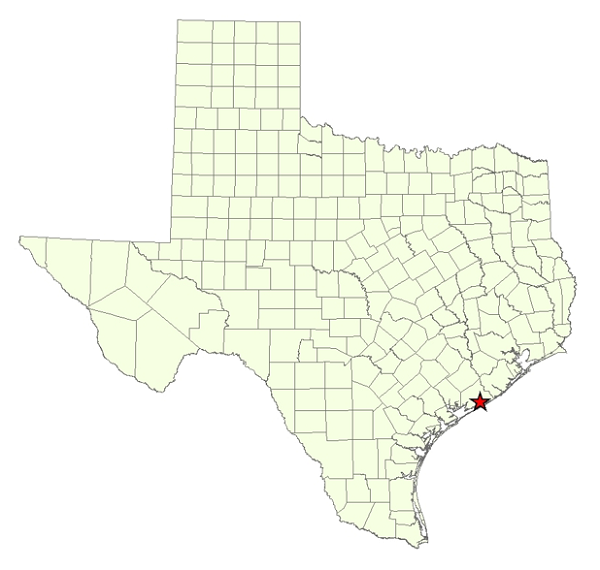
Commission Agenda Item No. 9
Exhibit A
Location Map for Matagorda Peninsula Coastal Management Area in Matagorda County
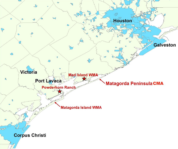
Commission Agenda Item No. 9
Exhibit B
Vicinity Map for Matagorda Peninsula
45 Miles East of Port Lavaca
Commission Agenda Item No. 9
Exhibit C
Project Area Map Showing East Matagorda Bay and the Location of the
Original and Current Brown Cedar Cut
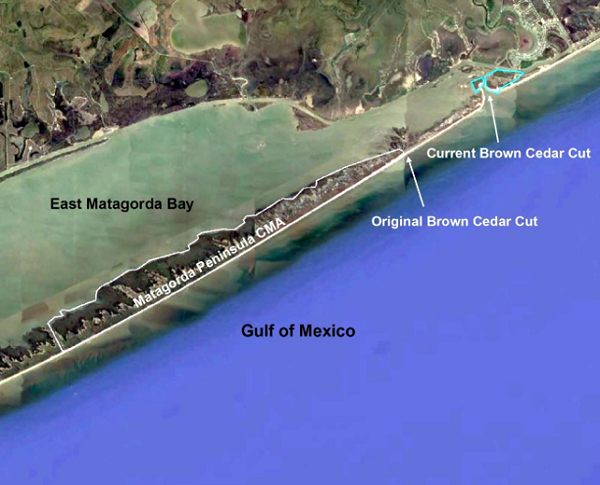
Commission Agenda Item No. 9
Exhibit D
Site Map for Subject Approximately 172-Acre Property