GIS and the Coastal Environment
Kim Ludeke, PhD, former Director GIS Lab, Texas Parks and Wildlife Department
In the past decade, geographic information systems (GIS) technology has become widely used, especially in the coastal environment. The Texas Parks & Wildlife GIS Lab has been at the forefront of making this technology available for practical applications.
First, it might be helpful to explain what is meant by GIS. In simple terms, it is the use of computer-based technology to help people better understand location in relation to both the earth’s natural and its man-made environment. It includes technologies such as GPS or global positioning systems, remote sensing (both aerial and satellite photography), and computer mapping and analysis.
By this time, most people utilizing the vast resources of the Texas coast have probably used, or at least heard of, GPS. These have become necessary instruments for finding your location along the open coast and in hidden bays and channels, especially where there are few easily recognizable landmarks. A GPS unit is essentially a highly sensitive receiver combined with an extremely accurate clock. It receives signals from 3 or more Department of Defense satellites to assist the user determine location with a high degree of accuracy. It can help specify where on the earth’s surface someone is currently located or how to navigate to a location for which she has the coordinates. In many instances it has replaced more traditional navigation tools.
GPS technology has been used by TPWD Law Enforcement to specify where crimes have occurred along the Texas Coast. Combining a GPS location with a digital aerial or satellite photograph helps Game Wardens demonstrate illegal acts to a court of law – for example, that the accused was indeed in a “no fishing” zone. In more than one instance this type of technical documentation has helped to seal the case. On the other hand, the public can use GPS locators to help them avoid these zones. In addition, GIS staff used GPS and digital aerial photography to map the paddling trails along the Texas coast. These trails include markers which can be located by navigating to them using GPS.
Digital aerial or satellite photography of the Texas coast is another area where GIS has had tremendous impact on resource management. When combined with GPS the photographs can help the user see where he is in relation to the coastline or important coastal points of interest. Fortunately, in the mid 90’s the U.S. Geological Survey (USGS) teamed up with other federal agencies and Texas state and local governments to produce a complete digital aerial photographic coverage of Texas. The photos are “false color infrared” which means that vegetation appears reddish and clear water black. They can be acquired and viewed through the Texas Natural Resources Information System (TNRIS) at www.tnris.org. Currently, Texas is partnering with the Farm Service Agency and the USGS to acquire a more up-to-date set of digital aerial photography. Hopefully, these will also be available within 6 months. Further, the University of Texas Center for Space Research has late 1990s and early 2000s satellite imagery available for all of Texas. These are valuable for looking at large areas of Texas. Again TNRIS is your source for these.
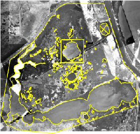
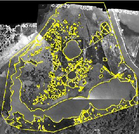
Maps derived from historical aerial photography were used to benefit the coastal environment as part of the GIS Lab Salt Bayou project. Duane German and Marian O’ Brien scanned historical photography dating from 1938 to 2001 and mapped the amount of open water contrasted to the amount of marsh for each date. GIS analysis of this photography evaluated changes in the amount of open water during that 63-year period. The resultant information is being used to help make decisions about the best practices to manage the Salt Bayou portion of the Sabine Lake estuary to protect nursery habitat of sportfish and shrimp. For example, this analysis shows that open water increased from 27.5 % coverage in 1967 to 33.9 % coverage in 2001. The highest rate of change was from 1967 to 1979, which coincided with the opening of Keith Lake Fish Pass. Documenting where loss of marsh has occurred and the rate that it is being lost allows managers of this important resource to consider changes to the system that will stop and hopefully to reverse this destruction. The graphics below show the results of the analysis. Image from 1967 is on the left and image from same area from 1979 is on the right.
© Copyright Texas Parks and Wildlife Department. No part of this work may be copied, reproduced, or translated in any form or medium without the prior written consent of Texas Parks Wildlife Department except where specifically noted. If you want to use these articles, see Site Policies.