
Fishing
- Possession and Transport of Exotic Aquatic Species
- Licenses & Regulations
- ShareLunkers
- Fish Identification
- Fish Consumption
- Texas Freshwater Fisheries Center
Water Resources
- Texas Reservoir Levels
- US Army Corps of Engineers
- Texas Water Issues
- Golden Alga
- Aquatic Vegetation
3802 East End Blvd. South
Marshall, Texas 75672
(903) 938-1007
Tim Bister, Biologist
Local Information
- Mount Pleasant Chamber of Commerce
1604 N. Jefferson
PO Box 1237
Mount Pleasant, Texas 75456-1237
(903) 572-8567
Nearby State Parks
Lake Bob Sandlin
Quick Links: Fishing Regulations | Angling Opportunities | Cover & Structure | Tips & Tactics
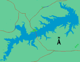
Lake Characteristics
Location: On Big Cypress Creek 5 miles
southwest of Mount Pleasant in Titus, Camp, and Franklin counties
Surface area: 9,004 acres
Maximum depth: 65.6 feet
Impounded: 1977
Water Conditions
Current Lake Level
Conservation Pool Elevation: 337.5 ft. msl
Fluctuation: 2-3 feet annually
Normal Clarity: Moderate, 2-4 feet
visibility
Reservoir Controlling Authority
Titus County Freshwater Supply District (903) 572-1844
Aquatic Vegetation
Coverage less than 3% of the lake's total surface area. The dominant species is hydrilla.
Predominant Fish Species
Lake Records
Current
Fishing Report
Stocking History
Latest Survey Report
Lake Maps
Commercial maps may be available.
Fishing Regulations
All species are currently managed under statewide regulations.
Angling Opportunities
Lake Bob Sandlin offers many quality options when pursuing sportfish. The largemouth bass population is moderately abundant with good numbers of legal-size fish available for harvest. Spotted bass are present but at low densities. White bass is a popular species with high numbers of quality size fish. Channel catfish in recent years have become more abundant across all size classes, and there are plenty of good-sized fish available for harvest. Good numbers of legal size crappie are present and provide good fishing opportunities. Redear sunfish, the dominant sunfish species in the lake, are moderately abundant and also showing good sizes.
| Species | Poor | Fair | Good | Excellent |
|---|---|---|---|---|
| Largemouth Bass | ||||
| Spotted Bass | ||||
| Catfish | ||||
| Crappie | ||||
| White Bass | ||||
| Sunfish |
Fishing Cover/Structure
Natural habitat is present in the form of inundated timber and aquatic vegetation. There are also numerous boat docks and fishing piers.
There are 6 artificial fish habitat sites on this lake. Anglers may use GPS in conjunction with a fish finder to locate these structures.
Use the Habitat Structure Viewer for an interactive map of fish habitat structures and downloadable GPS coordinates.