Fishing
- Possession and Transport of Exotic Aquatic Species
- Licenses & Regulations
- ShareLunkers
- Fish Identification
- Fish Consumption
- Texas Freshwater Fisheries Center
Water Resources
- Texas Reservoir Levels
- US Army Corps of Engineers
- Texas Water Issues
- Golden Alga
- Aquatic Vegetation
PO
Box 835
Canyon, Texas 79015
(806) 655-4341
Caleb Huber, Biologist
Local Information
- Lakeside Marina
PO Box 238
Clarendon, Texas 79226
(806) 874-5111
Nearby State Parks
Greenbelt Reservoir
Quick Links: Fishing Regulations | Angling Opportunities | Cover & Structure | Tips & Tactics
This area is experiencing a drought which may affect fishing and boat ramp access. Before you go, check the current lake level or contact the controlling authority for current conditions.
Lake Characteristics
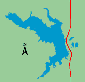
Location: 60 miles east of Amarillo and
4 miles north of Clarendon on the Salt Fork of the Red River
Surface area: 1,990 acres possible, currently
about 1,500 acres
Maximum depth: 84 ft., mean depth
30 ft.
Impounded: 1967
Water Conditions
Current Lake Level
Conservation Pool Elevation: 2,663 ft. msl
Fluctuation: Moderate, 2-4
ft. per year
Normal Clarity: 4-6 ft. visibility
Reservoir Controlling Authority
Greenbelt Municipal and Industrial Water Authority
PO Box 665
Clarendon, Texas 79226
(806) 874-3650
Aquatic Vegetation
Vegetation in Greenbelt includes potamogeton, coontail, milfoil, and cattails. Vegetation can be dense around shoreline areas and coves. In Kelly Creek and the Salt Fork, there are stands of flooded timber.
Predominant Fish Species
Lake Records
Current
Fishing Report
Stocking History
Latest Survey Report
Lake Maps
A general information map is available from the Lakeside Marina (information above). Sporting goods and tackle stores sell maps of lakes, especially those lakes in the local area.
Fishing Regulations
All species are currently managed under statewide regulations.
Angling Opportunities
Largemouth bass are the most popular species in the reservoir. Crappie are abundant, and the reservoir has a good population of walleye with April through June being the best season for fishing. White bass are frequently caught during summer and fall months as they chase small shad in open water.
| Species | Poor | Fair | Good | Excellent |
|---|---|---|---|---|
| Largemouth Bass | ||||
| Smallmouth Bass | ||||
| Channel Catfish | ||||
| Flathead Catfish | ||||
| Crappie | ||||
| White Bass | ||||
| Sunfish | ||||
| Walleye |
Fishing Cover/Structure
Primary fish habitat in the reservoir is rock, sand, aquatic vegetation and flooded terrestrial vegetation. The reservoir can develop extensive stands of aquatic vegetation, especially in the Salt Fork arm. The water is clear and develops good plankton blooms. Visibility is usually four to six feet.
Tips & Tactics
Largemouth bass can be caught on a wide variety of baits depending on season and water conditions. The best season for bass fishing is spring when water temperatures reach about 60 degrees. Common lures include plastic worms, spinner baits and crank baits. Anglers should target areas with some type of structure such as trees, vegetation, drop-offs or ledges. Good catches of crappie frequently are found around flooded timber in the arms of the reservoir in the spring and fall and along the rip-rap of the dam when the fish move to deeper water. Crappie are best caught with jigs or minnows vertically fished around structure. Walleye are most often caught along the dam and around rock or sand points and drop-offs. The key to catching walleye is to use light line (6-pound test or less) and live bait or small jigs or lures. Fish very slow in water 10-20 feet deep. Good baits for white bass are crank baits that imitate shad or live shad or minnows. Schools of white bass can often be found in the large open-water areas of either arm of the reservoir or the main reservoir near the bubbler on the dam.
