- Table of Contents
- Foreword
- Introduction
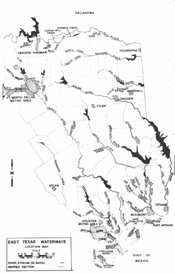
- Texas Waterway Map
- Map Key
- East Texas Waterways
- Central Texas Waterways
- Major Waterways:
- Blanco River
- Bosque River
- Brazos River
- Colorado River
- Concho River
- Frio River
- Guadalupe River
- Lampasas River
- Lavaca River
- Leon River
- Little River
- Llano River
- Medina River
- Navidad River
- Nueces River
- Paluxy River
- Pedernales River
- San Antonio River
- San Bernard River
- San Gabriel River
- San Marcos River
- San Saba River
- Wichita River
- Seasonal and Restrictive Waterways
- Major Waterways:
- West Texas Waterways
An Analysis of Texas Waterways
A Report on the Physical Characteristics of Rivers, Streams, and Bayous in Texas
Major Waterways of East Texas
Angelina River
This section contains maps and an analysis of the more popular and scenic sections of rivers, streams and bayous in East Texas and short verbal descriptions of other sections of these same waterways. East Texas waterways are characterized by lush vegetation, deep and slow-moving water, low banks and meandering courses.
Angelina River
Formed by the junction of Barnhardt, Scober, and Shawnee Creeks in Rusk County, the Angelina River flows about 119 miles through Cherokee, Nacogdoches, Angelina, San Augustine, and Jasper Counties, joining the Neches River 12 miles west of Jasper. The Angelina is a meandering stream flowing through forested bottomlands. The water is of high quality and comparatively deep. Since there is usually adequate water, recreational use is feasible on the lower section almost any time of the year. Two reservoirs are located on the Angelina River - Sam Rayburn Reservoir and B. A. Steinhagen Lake. Both impoundments offer public camping and picnic facilities.
Farm-to-Market 1798 to State Highway 21
(Not mapped)
38 miles
The upper reaches of the Angelina River in Rusk and Cherokee counties, flow through scenic, heavily forested East Texas countryside. Waterflow is variable; however, during periods of run-off, a sufficient amount of water usually is available for recreational use. The best sections of the upper reaches are: 1) a 5-mile stretch from the US 84 crossing (15 miles northeast of Rusk) to SH 204 crossing (six miles west of Cushing). Data indicates that there are approximately 1000 feet of shoreline within the highway right-of-way available to the public at the US 84 crossing. A roadside park is located at SH 204 crossing and approximately one-fourth mile of shoreline may be available for public use. 2) A swampy 16-mile section from SH 204 crossing to FM 343 crossing (east of Rusk). Data indicates that there are approximately 1000 feet of shoreline on the highway right-of-way available for public use at SH 204 and FM 343 crossing. 3) A 17-mile stretch from FM 343 crossing to SH 21 crossing (seven miles east of Alto). This section passes through land belonging to lumber companies. It was found that many lumber companies allow public access to portions of their lands; however, advance permission was a prerequisite.
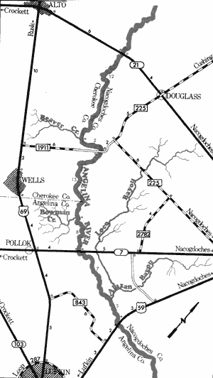
Angelina River
State Highway 21 to US Highway 59
46 Miles
State Highway 21 to US Highway 59
46 miles
This 46-mile section of the Angelina River flows through portions of Cherokee, Nacogdoches and Angelina Counties. Stream flow often fluctuates along this section; however, due to the many feeder streams, the river maintains adequate water for recreational use in all but very dry periods. Very little current is evident at normal water levels. This section flows through heavily timbered bottomlands, mostly owned by large lumber companies. Many of these lands are presently open to the public. Many log and brush jams often appear along this section, which result in navigational difficulties.
Recreational use of this section is feasible between the SH 21 crossing, seven miles east of Alto, and the US 59 crossing. Additional waterway features and distance between each are as follows:
Beaver Creek - Enters on the right. (12 miles)
County road crossing - between FM 1911 and FM 225, 12 miles west of Nacogdoches, and 12 miles southeast of Alto. (2 miles)
International Paper Company land - 12 miles
southeast of Alto. About 1500 Feet of shoreline are available. (0.1 mile)
Bowman Creek - enters on the right. (13 miles)
SH 7 crossing - 12 miles southwest of Nacogdoches. A Texas Parks & Wildlife Department boat ramp is available. (6 miles)
Alazan Bayou - enters on the left. (7 miles)
US 59 crossing - 12 miles south of Nacogdoches. 600 feet of shoreline are available to the public just north of the US 59 crossing, and also 500 feet of shoreline at the crossing. (5 miles)
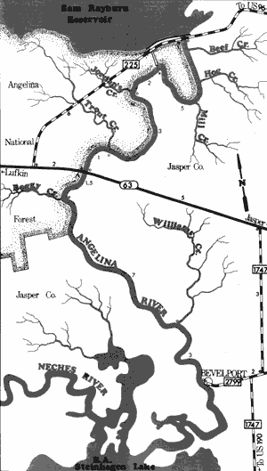
Angelina River
Sam Rayburn Reservoir to Bevelport
17.5 Miles
Sam Rayburn Reservoir is located about 20 miles downstream from the US 59 crossing. The U.S. Army Corps of Engineers operate public parks around the reservoir, which are often utilized by waterway recreationists.
Sam Rayburn Reservoir to Bevelport
17.5 miles
This 17.5-mile section of the Angelina River is one of the most scenic waterways in East Texas. Located within the boundaries of Jasper County, the stream width varies from 75 to 150 feet with the water being clean and deep. The current is moderate when the dam at Sam Rayburn Reservoir is discharging. However, analysis indicates that there will usually be enough water to permit recreational activities even if no water is being released. The Angelina National Forest borders the river along the upper half of this section and portions of the shoreline are public property. Also, the river contains many sand bars which often lend themselves to camping and day use. Fishing and wildlife observation opportunities are excellent. No particular hazards were found along this section.
In addition, this section provides access to a five-mile loop of the old river channel which can only be reached where it joins the new channel (see map).
Recreational use of the section from the Spillway to Bevelport usually begins below the dam where the new channel meets the old river channel (just off FM 225 on the western end of the dam). Additional waterway features and distance between each are as follows:
Jordan's Creek - enters on the right. (2 miles)
Trout Creek - enters on the right. (3 miles)
SH 63 crossing - 10 miles northwest of Jasper, a TPWD boat ramp is available. (1 mile)
Private Camp - located just downstream from SH 63 crossing. (0.1 mile)
Boggy Creek - enters on the right. (1.5 miles)
Williams Creek - enters on the left. (7 miles)
Bevelport - Texas Parks & Wildlife Department boat ramp is located off FM 2799. (3 miles)
Waterway recreationists are able to extend float trips down this section an additional seven miles by continuing to B. A. Steinhagen Lake. The river is sluggish along this section and no current exists. Martin Dies, Jr. State Park is an additional four miles across the open lake.
Top of Page | Table of Contents