- Table of Contents
- Foreword
- Introduction
- Texas Waterway Map
- Map Key
- East Texas Waterways
- Central Texas Waterways
- Major Waterways:
- Blanco River
- Bosque River
- Brazos River
- Colorado River
- Concho River
- Frio River
- Guadalupe River
- Lampasas River
- Lavaca River
- Leon River
- Little River
- Llano River
- Medina River
- Navidad River
- Nueces River
- Paluxy River
- Pedernales River
- San Antonio River
- San Bernard River
- San Gabriel River
- San Marcos River
- San Saba River
- Wichita River
- Seasonal and Restrictive Waterways
- Major Waterways:
- West Texas Waterways
An Analysis of Texas Waterways
A Report on the Physical Characteristics of Rivers, Streams, and Bayous in Texas
Major Waterways of Central Texas
Guadalupe River
The Guadalupe River is one of the most popular rivers in Texas. Rising it its North and South Forks in Kerr County, the spring-fed stream flows eastward into Kendall and Comal Counties where it then turns and flows south to the Gulf of Mexico. Its total length is approximately 250 miles. One major reservoir, Canyon Reservoir, and several smaller ones, Lake McQueeney, Lake Dunlap, Lake Placid, Lake Gonzales, Wood Lake, and Meadow Lake, are located on the river. The river is extremely scenic, and a sufficient water flow for recreational use exists throughout its entire length, with the exception of the extreme upper reaches.
Confluence of North and South Forks to Waring
(Not mapped)
38 miles
The Guadalupe River has its beginning in springs forming the North and South Forks in western Kerr County. These two forks join in the vicinity of the town of Hunt, and the main stream flows eastward into Kendall County. The Upper Guadalupe is a very scenic river having crystal clear water, bald cypress lined banks, along with vegetation and geological formations typical of the Edwards Plateau. However, the river is extremely narrow and shallow, and conditions are not conducive for recreational use until the river reaches the vicinity of Comfort and Waring. Kerrville State Park is located on the upper reaches below the confluence of the two forks. A series of eight small low water dams are located between Kerrville and Comfort. These dams do not seriously restrict water flow. Below the sixth dam (approximately 2 miles above Comfort), a mill channel with a 10-foot waterfall exists.

Guadalupe River
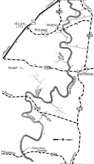
Waring to Farm-to-Market 3160
39 Miles
Waring to Farm-to-Market 3160
39 miles
This 39-mile section of the Guadalupe River in Kendall County is an excellent section for recreational use. The river is very scenic and contains many small rapids and only a few potentially dangerous places. The river is 30 to 40 feet wide, with high limestone bluffs and typical Edwards Plateau vegetation lining the banks. In places the riverbed flattens out to reveal ranch and pasture land. Water levels are good and there is normally sufficient water for recreational use.
The only potential hazards which are found are limbs and brush which hang out over the river and several low water crossings. Camping areas are a problem since there are few sand and gravel bars that lend themselves to camping and day use. There are several road crossings which provide good access. Waterway features and distance between each are as follows:
County road crossing - off FM 473, 4 miles
northwest of Waring. The river is not
passable beneath the bridge.
County road crossing - off FM 473, 3 miles
northwest of Waring. The river is not
passable beneath the bridge.
County road crossing - off FM 473, 2 miles
northwest of Waring. This is actually a
ford. (1 mile)
County road crossing - off FM 473, just north
of Waring. At low water levels, the river is
passable beneath the bridge. (2 miles)
Zoeller's crossing - county road crossing off
FM 473, 2 miles northwest of Waring.
At low water levels, the river is passable
beneath the bridge. (3 miles)
Violet Creek - enters on the right.
Private camp - located on the private road
west of Ranch Road 1376, 3 miles
south of Sisterdale. The only facilities
available are picnic tables. (5 miles)
Ranch Road 1376 or Sisterdale crossing -
2 miles south of Sisterdale. (1 mile)
Wasp Creek - enters on the right.
FM 474 crossing - 7 miles north of Boerne.
(11 miles)
Boss Creek - enters on the left.
Old Sultenfuss crossing - 5 miles north
of the community of Bergheim. This
crossing has been closed off to the
public. (14 miles)
FM 3160 crossing - 5 miles north of the
Community of Bergheim. Access to
the river is attained on the road right-of-way by walking down the steep
bank on the north side of the river.
(0.1 mile)

Guadalupe River
Farm-to-Market 3160 to Rebecca Creek Crossing
22.4 Miles
Farm-to-Market 3160 to Rebecca Creek Crossing
22.4 miles
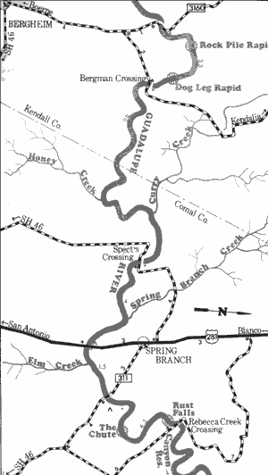
This 22-mile section of the Guadalupe River in Kendall and Comal Counties is one of the most scenic stretches of river in Texas, and has been the subject of intense study by the Texas Parks & Wildlife Department ("Pathways and Paddleways"). Except during periods of extreme drought there is always sufficient water in this section of the Guadalupe River for recreational use. A reading of 5.35 feet, or 175 cubic feet per second (CFS), or higher, or the Spring Branch gage (maintained by the Guadalupe-Blanco River Authority) results in conditions that are excellent for recreational use. The optimum level for safe recreation use has been determined to be 1000 CFS.
The immediate area of the river has been found to be extremely scenic, with high limestone bluffs, giant bald cypress, pecan, cottonwood, oak, elm, palmettos, and a wide variety of shrubs, vines, and forbs lining the river. Just downstream from FM 3160, a side creek flows into the river over a travertine waterfall.
There are at least 55 rapids on the 22.5 mile stretch, most of which are navigable and cause few problems to recreationists. However, there are four areas which demand careful inspection. The first, known as the Rock Pile Rapid, is located one mile below the FM 3160 Crossing. The many large rocks create difficult passage. the second rapid is the Dog Leg Rapid. Here, the river makes a sharp right turn in conjunction with a very steep gradient. The rapid is located about 3 miles below the FM 3160 Crossing.
The third obstacle is Mueller Falls, located approximately 1.5 miles below FM 311 crossing. The main falls are dangerous to float trips. However, a chute to the left of the island creates an exciting fast water run for the adventuresome. The water flows swiftly around the island, encountering a series of bald cypress trees in the middle of the channel. The last major obstacle is Rust Falls, located one-quarter mile above the Rebecca Creek Crossing. This is a major falls and is very dangerous. However, a small chute to the left of the falls near the bald cypress trees in the river provides an exciting passageway. All of these hazardous areas can be portaged by recreationists utilizing the river for float trips.
There are six road crossings located along this stretch; however, they are spaced at intervals varying in length from half a day to two day float trips. Waterway features and distance between each are as follows:
FM 3160 crossing - 5 miles north of the
community of Bergheim. Access to
the River is attained on the road right-of-way by walking down the steep bank
on the north side.
Bergman crossing - county road crossing,
5 miles northeast of Bergeim. At below
normal and normal water levels, the river
is passable beneath the bridge.
(3.4 miles)
Honey Creek - enters on the right. (5 miles)
Curry Creek - enters on the left. (2 miles)
Spect's crossing - county road crossing,
3 miles west of Spring Branch. At
below normal and normal water levels,
the river is passable beneath the bridge.
(2 miles)
Spring Branch Creek - enters on the left.
(2.5 miles)
Private camp - located adjacent to US 281
on left bank.
US 281 crossing - 2 miles south of Spring
Branch. The high bridge provides poor
access. (1.5 miles)
Elm Creek - enters on the right. (0.5 mile)
FM 311 crossing - 2 miles southeast of
Spring Branch. Access is available on
the Highway right-of-way. (1 mile)
Private camp - on private road off FM 311.
Camping facilities are available.
(0.5 miles)
Rebecca Creek crossing - county road
crossing, 3 miles east of Spring Branch.
Poor access is provided. This is the last
road crossing above the backwaters of
Canyon Reservoir. (4 miles)

Guadalupe River
Canyon Dam to New Braunfels (Interstate Highway 35)
24 Miles
Canyon Dam to New Braunfels (Interstate Highway 35)
24 miles
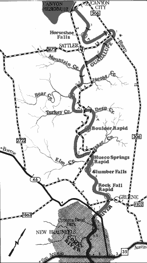
This 24-mile section of the Guadalupe River in Comal County is considered one of the finest white-water stretches in the State. The river is scenic, with limestone bluffs, bald cypress, pecan, elm and other vegetation lining the banks. The river area presently is being subjected to intense development, with many subdivisions and fishing camps becoming evident. However, many natural areas can still be found. The flow of the river is largely controlled by water releases from Canyon Dam. Good conditions for recreational use are at all levels between 50 and 1000 cubic feet per second (CFS).
However, the most pleasurable conditions are available when the flow is between 450 and 750 CFS. The water is very cold and clear since it come directly form the bottom of Canyon Reservoir.
Several low water dams located on this stretch are hazardous to recreationists. Also present are two major waterfalls - Horseshoe Falls and Slumber Falls. Slumber Falls is passable if extreme caution is exercised; however, Horseshoe Falls is never passable. Here, the river plummets over a horseshoe-shaped ridge and crashes approximately 6 to 8 feet downward. A strong undertow is created by the falls. The remaining potential hazards are the low water road crossings and the many rapids which span the river. Some of the better rapids which can be hazards to recreationists are the Boulder Rapid, the Hueco Springs Rapid, and the Rock Falls Rapid. Beyond the hazards and rapids mentioned, the remainder of the river is serene and placid. The river flows gently past limestone bluffs and bald cypress-lined banks.
Flowing southeast and joining the Guadalupe River at New Braunfels is the Comal River which has its source in the hilly, large Comal Springs within the city. The Comal is the shortest river in Texas, being only two and one-half miles in length and having an average flow of 330 cubic feet per second. This flow adds significantly to the flow of the Guadalupe.
Of particular interest to the recreationist are the many fishing and swimming camps, Landa Park, and the textile industry in New Braunfels. A small dam and several small spillways requiring portages are located along the river. Flowing over smooth limestone beds with numerous small rapid areas, the Comal is open for recreational usage year-round with the spring and summer months being highly utilized. Additional waterway features on the Guadalupe and distance between each are as follows:
Corps of Engineers park - immediately below
Canyon Dam. A road to the left of a hill
takes cars down to the river just below
the spillway.
Private camp - off FM 306, 2 miles southeast of Canyon City at Horseshoe Falls. (2 miles)
FM 306 crossing - 2 miles east of Canyon City. The high bridge provides poor access. (1 mile)
Private camp - 3 miles east of Canyon City off FM 306. Facilities are available for camping and
picnicking and about 2 miles of shoreline provide access. (0.5 mile)
FM 306 crossing - 3 miles east of Canyon City. The high bridge provides poor access.
(0.5 mile)
River Road crossing - county road crossing, off FM 2673. (2 miles)
Private road crossing - 2 miles south of Sattler. No access is available unless permission
is obtained to use the road. (1 mile)
Private camp - 4 miles south of Sattler on the river road. Approximately 1 mile of shoreline
is available, and camping and picnicking facilities are provided. (3 miles)
Private camp - 5 miles south of Sattler on the river road. Approximately 1 mile of shoreline
is available along with camping and picnicking facilities. (1 mile)
River Road crossing - 6 miles north of New
Braunfels. (1 mile)
Private camp - 6 miles north of New
Braunfels off the river road. About 1 mile
of shoreline is available along with
camping and picnicking facilities.
(0.1 mile)
Private camp - 5 miles north of New Braunfels.
About one-half mile of shoreline is
available. Camping and picnicking
facilities are provided. (1 mile)
River Road crossing - 4 miles north of New
Braunfels. (1 mile)
Private camp - 4 miles north of New Braunfels
on the river road. About 1 mile of shoreline
provides good access. Camping and
picnicking facilities are provided. (1 mile)
River Road crossing - 3 miles north of New
Braunfels. (1 mile)
Private camp - 3 miles north of New
Braunfels, just downstream from the
last river road crossing. (0.1 mile)
Private camp - 2 miles north of New
Braunfels at Hueco Springs. (1 mile)
Gruene Crossing - county road between
FM 306 and SH 46, 1 mile north of
New Braunfels. (3 miles)
SH 46 crossing - located on the northern
city limits of New Braunfels. (1 mile)
Cypress Bend Park - A city park in New
Braunfels provides 1 mile of shoreline.
Camping facilities are available.
(1.5 miles)
Comal River - "The shortest river in Texas,"
enters on the right. This river may be
explored for 2.5 miles upstream to
Comal Springs. Several private camps
are located along the banks. (0.5 mile)
IH 35 crossing - A Texas Parks & Wildlife
boat ramp is located beneath Interstate
Highway 35 in New Braunfels. (1 mile)
Interstate Highway 35 to Victoria City Park
(Not mapped)
200 miles
The Guadalupe River below New Braunfels eventually becomes a twisting, turning, coastal river. The river is scenic, but the limestone bluffs that are characteristic of the upper sections are no longer prevalent. The river is very slow-moving and no rapids of any consequence exist. The major hazards include many log jams along with some small dams. Six small reservoirs - Lake Dunlap, Lake Placid, Meadow Lake, Lake Gonzales, Wood Lake, and Lake McQueeney have been established on the river in Guadalupe and Gonzales Counties. However, the lower Guadalupe below these impoundments is feasible for recreational use. Numerous sand bars which often lend themselves to camping and day use are found. Access is no problem due to the existence of several road crossings. The most interesting sections of the lower Guadalupe reportedly are: (1) a 21-mile section from Independence Park in Gonzales to US 183 crossing, 9 miles west of Yoakum, (2) a 30-mile section from US 183 crossing to Cuero, (3) a 35-mile section from Cuero to Nursery, (a potentially hazardous rapid exists approximately 3 miles above FM 447 at Nursery), and (4) a 20-mile section from Nursery to Victoria City Park.
Top of Page | Table of Contents