- Table of Contents
- Foreword
- Introduction
- Texas Waterway Map
- Map Key
- East Texas Waterways
- Central Texas Waterways
- Major Waterways:
- Blanco River
- Bosque River
- Brazos River
- Colorado River
- Concho River
- Frio River
- Guadalupe River
- Lampasas River
- Lavaca River
- Leon River
- Little River
- Llano River
- Medina River
- Navidad River
- Nueces River
- Paluxy River
- Pedernales River
- San Antonio River
- San Bernard River
- San Gabriel River
- San Marcos River
- San Saba River
- Wichita River
- Seasonal and Restrictive Waterways
- Major Waterways:
- West Texas Waterways
An Analysis of Texas Waterways
A Report on the Physical Characteristics of Rivers, Streams, and Bayous in Texas
Major Waterways of Central Texas
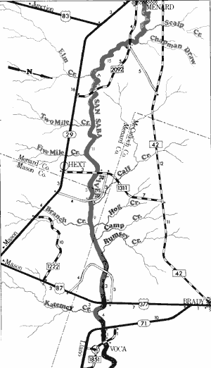
San Saba River
The San Saba River is a scenic waterway located on the northern boundary of the Edwards Plateau. From its beginnings in springs near the Schleicher-Menard county line, the San Saba flows approximately 100 miles east into Menard, Mason, McCulloch, and San Saba Counties joining the Colorado River. The San Saba is a typical Hill Country river consisting of sparkling, clear water which flows through limestone bluffs and hills. Typical Hill Country vegetation such as pecan, oak, sycamore, elm, cedar, yucca, and cacti are prevalent along the banks.
The river flows through predominantly ranch country although some farming activities are apparent near the flood plain. The San Saba remains relatively undeveloped and natural, since little residential development has appeared and no impoundments other than low water crossings exist.

San Saba River
Ft. McKavett to Farm-to-Market 2092
29 Miles
Ft. McKavett to Farm-to-Market 2092
29 miles
The San Saba River, from its headwaters near Fort McKavett to Menard, is a picturesque stream. The river meanders through scenic, heavily vegetated hills; and the water is crystal clear. However, the river is extremely narrow and shallow upstream from Menard. At normal water levels, there is insufficient water available for recreational use of this section, although there is limited potential during periods of high water. A few areas of swift water and some small rapids exist.
Of special significance to this section is the existence of two historical sites located along the banks. Fort McKavett is an old army post that was erected for the protection of the settlers in 1852. The fort was abandoned in 1859, was reoccupied for a short time during the Civil War, then General Ronald S. MacKenzie occupied the fort from 1868 to 1883 during the Indian campaigns. The fort is now a state historic park.
The San Saba presidio, located across the river from Menard, is one of the early forts of the Spanish Mission era. It was erected in 1757, but the mission, located a few miles downstream was very susceptible to surprise Indian raids. The mission was destroyed by Comanches in 1758 and the Spanish abandoned the presidio about 10 years later. The rock ruins now existing are the result of reconstruction efforts by Menard citizens in 1936.
Despite the exceptional historical, geological, and scenic qualities along this section of the San Saba, its recreational potential is severely limited by its insufficient flow. The river below Menard is better suited for most recreational uses. Waterway features and distance between each, and conditions of the river between Fort McKavett and Menard are as follows:
Fort McKavett Crossing - county road crossing off FM 864 just outside
of Fort McKavett. The low water crossing is fenced on all four sides.
The river is very narrow, shallow, and scenic.
FM 864 crossing - 1 mile east of Fort McKavett. The river is narrow, shallow,
and scenic. (1 mile)
FM 864 crossing - 5 miles northeast of Fort McKavett. The crossing is
fenced downstream. The river is 30 feet wide; lined with many trees;
has low banks; and is very shallow, clear, and scenic. (5 miles)
County road crossing - between FM 864 and
SH 29. Access is fenced off, the river is
shallow, wide, and clear with lots of
pecans, oaks, and grassy areas.
(1 mile)
County road crossing - off SH 29, 8 miles
west of Menard. Good access to the
river is available. The banks are low and
the river 10 feet wide and shallow downstream but 60 feet wide upstream.
(7 miles)
County road crossing - off SH 29, 4 miles
west of Menard. The river is narrow both
upstream and downstream and the
possibility of log jams is evident. The
water is clear and deep upstream with
recreational use possible at this point.
High limestone bluffs are found. (4 miles)
San Saba presidio - located 1 mile west of
Menard on the left bank, situated on the
municipal golf course. A small road
outside of the golf course entrance
provides access. (3 miles)
US 83 crossing - in the city of Menard. A
city park is located beneath the high
bridge on the flood plain. A low water
crossing is located immediately
downstream from the park. There is good
access, but the river is shallow. (2 miles)
FM 2092 crossing - 5 miles east of Menard.
Good access and plenty of parking is
available. The river is wide upstream but
narrow downstream, and is passable
beneath the bridge at normal water
levels. Gentle grassy banks and
pecan groves are found. (6 miles)
San Saba River
Farm-to-Market 2092 to Voca Crossing
46 Miles
Farm-to-Market 2092 to Voca Crossing
46 miles
This 46-mile section of the San Saba flows through Menard, Mason, and McCulloch Counties. The river along this section is scenic, flowing through heavily vegetated Hill Country. Varying in width from 20 to 50 feet, the normal water level is relatively shallow. Water quality along this section is excellent and several rapids exist. The river bottom is composed of limestone, and in several places large boulders protrude. Many limestone outcroppings are evident along the river, and vegetation is thick. The San Saba along this section remains in a natural state, and no pollution is visible. Access is adequate since there are several road crossings. Waterway features, distance between each, and conditions of the river are as follows:
FM 2092 crossing - 5 miles east of Menard.
There is good access and plenty of
parking. The river is wide upstream, but
narrow downstream. The river beneath the
bridge is passable at normal water levels.
Gentle grassy banks with many pecans
exist.
Private camp - 8 miles east of Menard off
FM 2092. Camping facilities are
available. (10 miles)
FM 2092 crossing - 10 miles east of Menard.
The river is 50 feet wide and deep
upstream, but only 10 feet wide and
shallow downstream. The river beneath
the crossing is passable. There is good
access and adequate parking space.
(5 miles)
FM 1311 crossing - 3 miles north of Hext.
The crossing is fenced off on all sides.
An old low water crossing is located just
upstream from this crossing. The river is
20 feet wide at this point. (11 miles)
County road crossing - 5 miles northeast of
Hext. This crossing possibly is a private
crossing. (3 miles)
County road crossing - 8 miles south of
Brady off US 377 and US 87. This
crossing possibly is a private crossing.
(9 miles)
US 87 and US 377 crossing - 8 miles south
of Brady. A roadside park located
immediately downstream from the
high bridge provides good access.
The river is shallow, but passable
beneath the high bridge. Large boulders
are located upstream. (3 miles)
SH 71 crossing - 10 miles southeast of Brady.
There is no access, and the river is fairly
shallow. (4 miles)
Voca Crossing - county road off FM 1851,
1 mile northwest of Voca. This crossing
provides poor access. The river is 50 feet
wide and small limestone bluffs are
present. (1 mile)
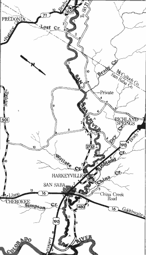
San Saba River
Voca Crossing to Colorado River
59 Miles
Voca Crossing to Colorado River
59 miles
This 59-mile section of the San Saba River in McCulloch and San Saba Counties provides the best conditions for recreational use of the river at normal water levels. The segment from the Voca Crossing to just above US Highway 190 contains crystal clear waters and many limestone outcroppings. However, when the river reaches US 190, the banks begin to steepen and the river becomes muddy. The water deepens considerably as the river moves slowly between steep banks. A few small rapids exist along the upper segment, but no rapids exist below US 190. The lower segment contains thickly vegetated banks. There are many road crossings and several private camps along this 59-mile stretch. Therefore, access is no problem except at the high bridges from US 90 to the Colorado River. The low water crossings from the Voca Crossing to US 190 provide adequate access. Waterway features, distance between each, and conditions of the river are as follows:
Voca crossing - county road off FM 1851, 1 mile northwest of Voca. This crossing
provides poor access. The river is 50 feet wide and small limestone bluffs are present.
County road crossing - off FM 1851, 4 miles east of Voca. The river is 75 feet wide
upstream and 50 feet wide downstream. There is plenty of water, many large
limestone bluffs and outcroppings, much vegetation, plus sloping banks and
sand bars. (5 miles)
Country road crossing - 10 miles south of Richland Springs. This possibly is a
private crossing. (9 miles)
County road crossing - off FM 2732 when extended. This has been found to be a
low water crossing with private ranch land immediately adjacent to the crossing.
The stream is 25 to 50 feet wide, containing many pecans, reeds, bulrushes. (4 miles)
Private camp - 10 miles southeast of Richland Springs on a road off FM 2732.
About 4.5 miles of shoreline are available and camping facilities are provided. (0.5 mile)
Private camp - 10 miles southeast of Richland Springs on the county road off FM 2732
when extended. This camp is located across the river on the opposite bank from the
preceding camp.
Private camp - off of FM 2732, 10 miles west of San Saba. (3 miles)
County road crossing - off FM 2732, 10 miles west of San Saba. The stream is 25 feet wide,
relatively shallow and lined with sycamores and elms. The water is clear, but banks
begin to get steep and muddy. Good access is available. (0.5 mile)
Private camp - 8 miles west of San Saba off FM 2732. About three-fourths mile of
shoreline are available, but no facilities are provided.
Private camp - 7 miles west of San Saba off FM 2732. About one and one-half miles
of shoreline are available, but no facilities are provided.
Private camp - 6 miles west of San Saba off US 190. About one and one-half miles of
shoreline are available, but no facilities are provided.
Private camp - 5 miles west of San Saba off FM 2732. About one and one-half miles
of shoreline are available, but no facilities are provided.
US 190 crossing - 4 miles west of San Saba. The high bridge provides no access. The
river is slow, sluggish, and deep. (12 miles)
Harkeyville Crossing - County road off US 190,
at Harkeyville. A high iron bridge provides
poor access. The river is 50 feet wide,
very sluggish, and the banks are heavily
vegetated, steep, and muddy. The water
quality deteriorates at this point. (0.5 mile)
County road crossing - one half mile north of
Harkeyville. This low water crossing
provides fair access. The river is 25 to
50 feet wide and water quality is poor.
(1 mile)
China Creek Road Crossing - 1 mile northwest of San Saba. The high iron bridge
provides poor access. The river is deep,
slow, and meandering. (6 miles)
SH 16 crossing - 1 mile north of San Saba.
A pecan orchard on private land blocks
access. (0.5 mile)
County road crossing - off FM 1480, 1 mile
east of San Saba. The high iron bridge
provides poor access. The banks are
steep, and the river is wide and deep.
(3 miles)
Private camp - 7 miles east of San Saba
off FM 1480. About one-half mile of
shoreline is available and camping and
picnicking facilities are provided.
County road crossing - between FM 1480
and US 190, 9 miles east of San Saba.
The high iron bridge provides poor access.
The river is wide, scenic, mostly slow-moving, but contains some swift areas.
(13 miles)
Private camp - just downstream from the
previous road crossing. About one-half
mile of shoreline is available, but no
facilities are provided. (0.1 mile)
Two miles downstream, the San Saba
joins the Colorado River.
Wichita River
Formed in northeast Baylor County by the union of its North and South Forks, the Wichita River flows approximately 90 miles through Archer, Wichita, and Clay Counties to join the Red River. There are two impoundments located on the Wichita River - Lake Kemp and Diversion Reservoir. Lake Kemp is formed approximately 10 miles below the junction of the North and South Forks. Diversion Reservoir is located about 15 miles below Lake Kemp Dam. The Wichita is not normally considered an exceptionally scenic river, yet it represents a major recreational resource to the north central portion of the State.
Confluence of North and South Forks to Lake Kemp
(Not mapped)
10 miles
The two upper forks of the Wichita River, under normal conditions, have sufficient water for recreational use. However, a steady increase of water is available from the confluence of the two forks to Lake Kemp. Back-up water form Lake Kemp also adds to the flow. Therefore, a small section immediately upstream from Lake Kemp would almost always have sufficient water to support recreational use. The stretch between Lake Kemp and Diversion Reservoir (14 miles) also appears feasible, depending upon water releases from Lake Kemp Dam.
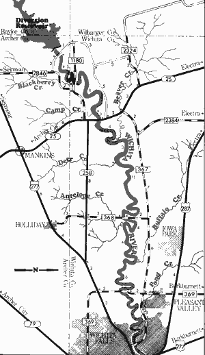
Wichita River
Diversion to Farm-to-Market 369
46 Miles
Diversion to Farm-to-Market 369
46 miles
This 46-mile section of the Wichita River is located in Archer and Wichita Counties. The river meanders between sand and caliche-colored banks, depositing many sand bars in the riverbed. Quicksand can possibly be found, although the sedimentation processes of the two reservoirs upstream have helped considerably to eliminate this problem.
The water levels for recreational use of this section of the Wichita River depend entirely upon water releases from Lake Kemp. There are seldom large volumes of water entering Lake Kemp, except during floods. Therefore, water releases from the dam generally are considered seasonal. When water is being released, recreational usage appears feasible. The Wichita River contains mesquite; willow; elm; sandy bottoms; and red, caliche-colored bluffs. No major rapids exist, although an occasional small rapid of area containing swift water possibly is present. Waterway features and distance between each are as follows:
County road crossing just below Diversion
Dam, 24 miles west of Wichita Falls.
Blackberry Creek - enters on the right.
(4.5 miles)
FM 1180 crossing - 21 miles west of Wichita
Falls. (0.5 mile)
Camp Creek - enters on the right. (8 miles)
SH 25 crossing - 17 miles west of Wichita
Falls. (1 mile)
Beaver Creek - enters on the left. (4 miles)
Deer Creek - enters on the right. (3 miles)
FM 368 crossing - 10 miles west of Wichita
Falls. (11 miles)
Antelope Creek - enters on the right.
(4 miles)
Buffalo Creek - enters on the left. (4 miles)
FM 369 crossing - 4 miles west of Wichita
Falls. (6 miles)
Farm-to-Market 369 to Red River
(Not mapped)
57 miles
The lower section of the Wichita River is a continuation of the segment immediately below Diversion Reservoir. Here, the river flows through the heart of the City of Wichita Falls and continues to the Red River. The city was named for a 5-foot waterfall on the river, which has since been washed away. The river does not have a steady flow of water and the best conditions for recreational use are available when the river is on a rise after heavy rains, or during periods when water is being released from Lake Kemp.
Top of Page | Table of Contents