- Table of Contents
- Foreword
- Introduction
- Texas Waterway Map
- Map Key
- East Texas Waterways
- Central Texas Waterways
- Major Waterways:
- Blanco River
- Bosque River
- Brazos River
- Colorado River
- Concho River
- Frio River
- Guadalupe River
- Lampasas River
- Lavaca River
- Leon River
- Little River
- Llano River
- Medina River
- Navidad River
- Nueces River
- Paluxy River
- Pedernales River
- San Antonio River
- San Bernard River
- San Gabriel River
- San Marcos River
- San Saba River
- Wichita River
- Seasonal and Restrictive Waterways
- Major Waterways:
- West Texas Waterways
An Analysis of Texas Waterways
A Report on the Physical Characteristics of Rivers, Streams, and Bayous in Texas
Major Waterways of Central Texas
Leon River
The Leon River is formed by the confluence of its North, Middle, and South Forks in Eastland County. The waterway flows approximately 185 miles southeast, eventually joining the Lampasas River to form the Little River. The upper reaches of the river would not normally be suitable for recreational use and has sufficient water only during periods of heavy runoff. The lower sections, however, have been determined to contain a sufficient flow for recreational use almost any time. These lower sections of the river pass through a scenic portion of the Cross Timbers area of Central Texas.
Lake Leon Dam to Gatesville
(Not mapped)
128 miles
The upper reaches of the Leon River generally flow southeast through hilly, scenic terrain. Being relatively unsettled and having mostly small farms and ranches, the entire area is characterized by rocky hills covered with post oak and cedar. Two reservoirs are located on the upper reaches - Lake Leon and Proctor Reservoir. Lake Leon is located in Eastland County just outside of the City of Eastland; and Proctor Reservoir is in Comanche County. Between the two reservoirs is a 31-mile section of river that is extremely narrow and shallow, rendering recreational use infeasible for this segment. Below Proctor Reservoir the river becomes suitable for recreational activities only during periods when water is being released from the dam and after heavy rains. Some small rapids are found; however, there exist no major obstacles other than occasional log jams.
There are many road crossings on the Leon River from Proctor Reservoir to Gatesville. Waterway features and distance between each are as follows:
US 67 crossing - below Proctor Dam, 8 miles northeast of Comanche.
County road crossing off FM 1476 - 8 miles east of Comanche. (4 miles)
FM 1476 crossing - 10 miles east of Comanche. (6 miles)
County road crossing off SH 36 - 1 mile northeast of Gustine. (3 miles)
County road crossing between SH 36 and FM 519 - 2 miles northeast of Gustine. (4 miles)
FM 1702 crossing - 4 miles east of Gustine. (3 miles)
County road crossing off SH 36 - 5 miles east of Gustine. (2 miles)
County road crossing off SH 36 - 1 mile north of the town of Lamkin. (5 miles)
County road crossing off SH 36 - 8 miles northwest of Hamilton on the
Comanche-Hamilton county line. (4 miles)
Private camp off US 281 - 6 miles northwest of Hamilton. (5 miles)
Private camp off SH 36 - 5 miles northwest of Hamilton. (1 mile)
County road crossing off US 281 - 4 miles northwest of Hamilton. (2 miles)
US 281 crossing - 5 miles north of Hamilton. (2 miles)
County road crossing off US 281 - 4 miles north of Hamilton. (1 mile)
County road crossing off US 281 - 6 miles northeast of Hamilton. (4 miles)
County road crossing off FM 219 - 5 miles northeast of Hamilton. (2 miles)
County road crossing off FM 1602 - 5 miles
northeast of Hamilton. (4 miles)
SH 22 crossing - 6 miles east of Hamilton.
(4 miles)
County road crossing off SH 22 - 7 miles
east of Hamilton. (5 miles)
SH 36 crossing - 1 mile west of Jonesboro.
(15 miles)
County road crossing off SH 36 - 9 miles
northwest of Gatesville. (12 miles)
County road crossing off FM 2412 - 4 miles
northwest of Gatesville. (10 miles)
US 84 crossing - western city limit of
Gatesville. (10 miles)
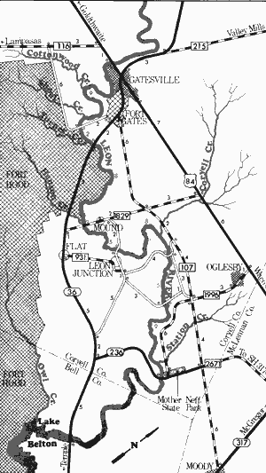
Leon River
US Highway 84 to Mother Neff State Park
46 Miles
US Highway 84 to Mother Neff State Park
46 miles
This 46-mile section of the Leon River, located in Coryell County from Gatesville to Lake Belton, usually has sufficient water for recreational activities. A number of creeks enter the river and the water is fairly deep. The banks of the Leon are steep, muddy, and lined with vegetation consisting of elm, willow, sycamore, and pecan. In many places, scenic vistas of oak and cedar-covered hills may be encountered.
The occasional log jams found on this section often hinder navigation. The river becomes sluggish in the lower portion of this section and eventually the back-up waters from Lake Belton are encountered.
A good point to begin recreational use of this section is the US 84 crossing near the western city limits of Gatesville. Additional waterway features and distance between each are as follows:
Cottonwood Creek - enters on the right.
Shoal Creek - enters on the right.
County road crossing off SH 36 - 4
miles south of Gatesville. (9 miles)
Turner Creek - enters on the right.
SH 36 crossing - 4 miles southeast of
Gatesville. (2 miles)
Henson Creek - enters on the right.
FM 1829 crossing - 9 miles southeast
of Gatesville. (8 miles)
County road crossing off FM 931 -
1 mile west of Leon Junction.
(5 miles)
Coryell Creek - enters on the left.
County road crossing off FM 107 -
9 miles southeast of Fort Gates.
(8 miles)
County road crossing off FM 107 -
5 miles southwest of Oglesby.
(5 miles)
Station Creek - enters on the left.
Mother Neff State Park - extreme
eastern portion of Coryell
County. (9 miles) Camping and
picnicking facilities are available
at the State Park. Belton Reservoir
is located below this site. Camping
and picnicking facilities are available
at Corps of Engineers parks around
the reservoir.
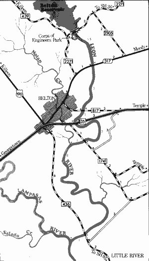
Leon River
Belton Reservoir to Lampasas River
17.5 Miles
Belton Reservoir to Lampasas River
17.5 miles
This 17.5-mile section of the Leon River is located in Bell County. Because of the existence of Belton Reservoir, the river depends on water releases from Belton Dam before the water level becomes sufficient for recreational use. The dam maintains a minimum amount of water for recreational use year round. Periods of heavy rainfall result in more and larger releases from the dam which create better recreational conditions. The optimum water flow reportedly is in the vicinity of 300 cubic feet per second (CFS). The waterway is scenic for a couple of miles below the dam. Heavy vegetation consisting predominantly of elm, willow, and sycamore are prevalent along the banks. Variations in gradient create a few areas containing fast water. However, the water quality quickly deteriorates below Belton as the river meanders slowly between steep, earthen banks.
Because of several road crossings and a Corps of Engineers park located below the dam, the river is easily accessible. However, steep, often muddy, banks must be contended with at some of these crossings. Waterway features and distance between each are as follows:
Corps of Engineers park - immediately
below Belton Dam.
SH 317 crossing - 2 miles north of the
city of Belton. (1.5 miles)
FM 817 crossing - northeastern city
limit of Belton. (3 miles)
IH 35 crossing - eastern city limit of
Belton. (1 mile)
FM 1741 crossing - 2 miles southeast
of Belton. (3 miles)
Nolan Creek - enters on the right.
(1 mile)
FM 436 crossing - 5 miles southeast of
Belton. (8 miles) The Leon River
joins the Lampasas River, forming
the Little River, one mile below
FM 436 crossing.
Little River
Formed in Bell County by the union of the Leon and Lampasas Rivers, the Little River flows generally southeast for 75 miles to join the Brazos River in Milam County. This waterway has sufficient water for recreational use at all times due to major inputs from its two tributaries. A third major tributary, the San Gabriel River, further increases the flow of water a short distance downstream. The Little River moves very slowly, winding between heavily vegetated banks for its entire distance. Few potential hazards to recreational use exist.
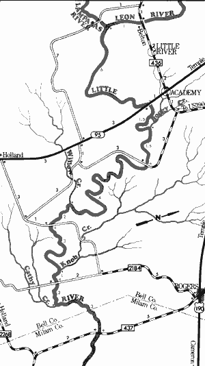
Little River
Farm-to-Market 436 to Farm-to-Market 437
25 Miles
Farm-to-Market 436 to Farm-to-Market 437
25 miles
This 25-mile section of the Little River flows through relatively flat farming country and no rapids or fast water exist. A number of high earthen bluffs are prevalent, particularly in the vicinity of the town of Little River. The river generally flows between steep, earthen banks.
Trees sometime fall across the stream and create a hindrance to navigation. Vegetation consists predominantly of willow, elm, and sycamore. There is always adequate water along this section to support recreational use, and no hazards other than occasional log jams are present. Several roads exist which provide access to the river. Waterway features and distance between each are as follows:
FM 436 crossing of the Leon River - 5 miles
southeast of Belton. A road beneath
the bridge goes down to the river.
Lampasas River - enters on the right.
(1 mile)
SH 95 crossing - 6 miles north of Holland.
50 feet of shoreline are available, and
a road goes down beneath the bridge.
(6 miles)
Boggy Creek - enters on the left. (1.5 miles)
County road crossing off FM 436 - 5 miles
west of Rogers. The bridge has been
washed out. (2 miles)
Willow Creek - enters on the right. (4 miles)
County road crossing off SH 95 - 4 miles
east of Holland. The bridge has been
washed out. (2 miles)
Knob Creek - enters on the left. (3 miles)
County road crossing off FM 2268 - 6 miles
east of Holland. The bridge has been
washed out. (1 mile)
Cathy Creek - enters on the right.
(2 miles)
FM 437 crossing - 15 miles west of
Cameron. A road goes down beneath
the bridge, but access is poor. (3 miles)
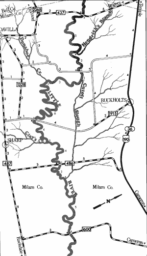
Little River
Farm-to-Market 437 to Farm-to-Market 1600
33 Miles
Farm-to-Market 437 to Farm-to-Market 1600
33 miles
This 33-mile section of the Little River is contained entirely within Milam County. The river along this stretch flows through relatively flat farm land, and no rapids are encountered. The river is slow-moving and contains heavy vegetation along its banks. The banks are steep and muddy, which makes access to the river at road crossings rather difficult. Water quality is fair although it usually has a murky appearance. There is normally adequate water for recreational use. The only potential hazards are occasional log jams. Five roads cross the river along this stretch, dividing it into segments that are relatively equal in length. Waterway features and distance between each are as follows:
FM 437 crossing - 15 miles west of Cameron. A road
beneath the bridge goes down to the river.
Hendrick's Branch - enters on the left. (5 miles)
County road crossing off FM 437 - 12
miles west of Cameron. (2 miles)
Cutoff Slough - enters on the left. (1 mile)
Donahoe Creek - enters on the right.
(3 miles)
County road crossing off FM 485 - 11
miles southwest of Cameron. (6 miles)
Clay's Creek - enters on the right.
(4 miles)
FM 486 crossing - 11 miles southwest
of Cameron. (4 miles)
Cutoff Slough - enters on the left.
(3 miles)
FM 1600 crossing - 8 miles south of
Cameron. 0.5 mile of shoreline are
available on the highway right-of-way.
(5 miles)
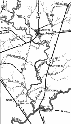
Little River
Farm-to-Market 1600 to Sugarloaf Mountain Crossing
38 Miles
Farm-to-Market 1600 to Sugarloaf Mountain Crossing
38 miles
This 38-mile section of the Little River flows through a scenic portion of Milam County. Of particular interest is the Sugarloaf Mountain area, located between the towns of Gause and Branchville. Sugarloaf Mountain is a unique sandstone spire which rises above the surrounding countryside.
Its variable banks of yellow, red, and rust colors are visible for miles and it is a major reference point. The river flows slowly between steep, heavily vegetated banks. There is normally an adequate supply of water for recreational use. No rapids exist, and an occasional log across the river is likely the only hazard. There are four road crossings along this section; however, river access from these crossings is difficult due to the steep banks. Waterway features and distance between each are as follows:
FM 1600 crossing - 8 miles south of
Cameron, 0.5 mile of shoreline is
available on the highway right-of-way.
San Gabriel River - enters on the right. This
river has potential for recreational use.
(3 miles)
Bear Creek - enters on the left. (8 miles)
Sandy Creek - enters on the right.
(1.5 miles)
US 77 and SH 36 crossing - 1 mile
southeast of Cameron. (0.5 mile)
County road crossing off FM 2095 - 2 miles
southwest of Cameron. (2 miles)
Big Elm Creek - enters on the left. (4 miles)
Cannonsnop Creek - enters on the right.
(8 miles)
Maysfield Creek - enters on the left.
(2 miles)
Hart Creek - enters on the left. (3 miles)
Pin Oak Creek - enters on the right.
(5 miles)
Sugarloaf Mountain crossing - off US 190,
13 miles southeast of Cameron. (1 mile)
Seven miles downstream, the Little River joins the Brazos River. Recreational float trips along this section are often extended an additional 10 miles to the US 79 crossing on the Brazos River.
Top of Page | Table of Contents