- Table of Contents
- Foreword
- Introduction
- Texas Waterway Map
- Map Key
- East Texas Waterways
- Central Texas Waterways
- Major Waterways:
- Blanco River
- Bosque River
- Brazos River
- Colorado River
- Concho River
- Frio River
- Guadalupe River
- Lampasas River
- Lavaca River
- Leon River
- Little River
- Llano River
- Medina River
- Navidad River
- Nueces River
- Paluxy River
- Pedernales River
- San Antonio River
- San Bernard River
- San Gabriel River
- San Marcos River
- San Saba River
- Wichita River
- Seasonal and Restrictive Waterways
- Major Waterways:
- West Texas Waterways
An Analysis of Texas Waterways
A Report on the Physical Characteristics of Rivers, Streams, and Bayous in Texas
Major Waterways of West Texas
Rio Grande (Part Two)
Rio Grande River
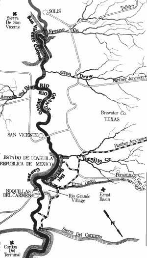
San Vicente and Hot Springs Canyons
19.5 Miles
Solis to Boquillas, Mexico (Including San Vicente and Hot Springs Canyons)
19.5 miles)
San Vicente and Hot Springs Canyons are two relatively short canyons which, when combined, create a fairly long recreation waterway of 19.5 miles. There is sufficient water for recreational use at any time and few possible hazards exist. Access is available at Solis (above San Vicente Canyon) and at the ford to Boquillas, Mexico (below Hot Springs Canyon). A National Park Service campfire/boat permit is required before recreational use is allowed.
San Vicente Canyon is a short but scenic canyon beginning immediately downstream from Solis. Here, the canyon was formed as the river cut through the north end of San Vicente Mountain. The river issues from the canyon at the point where Glenn Springs Draw joins the Rio Grande. There is a good rapid at the mouth of this dry creek. A section of open desert terrain is found for several miles between the two canyons. At the mouth of Tornillo Creek, a fairly large rapid exists. In addition, hot springs and the remains of an old vacation resort, which utilized the medicinal powers of hot springs, exist in the vicinity of and downstream from Tornillo Creek.
A short but scenic canyon, Hot Springs Canyon is found near Rio Grande Village. After the river issues from this canyon, it flows through relatively open country to the ford at Boquillas. Waterway features and distance between each are as follows:
Solis - It has been determined that adequate
access is available at this point.
San Vicente Canyon Entrance - The river has
cut through the north end of San Vicente
Mountain and canyon walls rise for
several hundred feet. (1 mile)
San Vicente Canyon Exit - The river issues
from the short canyon. (3 miles)
Glen Springs Draw - Enters from the left. A
rapid is found at the mouth of the creek.
(1 mile)
Tornillo Creek - This creek usually contains
a small flow of water, and a rapid is
present at its junction with the Rio
Grande. Several hot springs and the
remains of an abandoned vacation
resort are found in the vicinity of the creek.
(11 miles)
Hot Springs Canyon Entrance - This is a
short canyon which derived its name
from the numerous hot springs contained
within the canyon. (0.5 mile)
Hot Springs Canyon Exit - The river issues
from the Ernst Tinaja. (2 miles)
Rio Grande Village and the ford to Boquillas,
Mexico - A National Park Service
campground has been provided at Rio
Grande Village. A ford to the small
village of Boquillas, Mexico provides
good access. (1 mile)
Rio Grande River
Boquillas, Mexico to Stillwell Crossing (Including Boquillas Canyon)
26 Miles
Boquillas, Mexico to Stillwell Crossing (Including Boquillas Canyon)
26 miles)
This 26-mile section of the Rio Grande which includes Boquillas Canyon is an extremely scenic waterway. There are no potentially hazardous places, and water levels are suitable for recreational use almost any time. Access is available at the ford to Boquillas, Mexico and at Stillwell Crossing on the U.J. Adams Ranch. Permission needs to be obtained from Mrs. Adams in Alpine, or at the ranch through the Marathon telephone exchange. Alternative access points to the Adams Ranch are the La Linda bridge or at Maravillas Creek on the Black Gap Wildlife Management Area. A National Park Service campfire/boat permit is required before recreational use is allowed.
Boquillas Canyon presently receives very little use by recreationists as compared to the upstream canyons since access is restricted. However, the scenic beauty and wilderness character of this canyon mark this section as having the potential to provide a most meaningful recreational experience.
Below the ford to Boquillas, the river splits into two channels. The channel on the Mexican side is the widest and the best channel. Boquillas Canyon was formed as the Rio Grande cut through the Sierra Del Carmens. The walls of the canyon are less sheer and spectacular than those of either Santa Elena of Mariscal.
Flat, open desert is found below the canyon, to Stillwell Crossing on the Adams Ranch. The La Linda Crossing and Maravillas Creek are farther downstream. Waterway features and distance between each are as follows:
Ford to Boquillas, Mexico - Good access is
available. Camping facilities are available
at nearby Rio Grande Village.
Boquillas Canyon Entrance - The canyon has
been formed as the Rio Grande cut its
way down while the Sierra del Carmens
were formed. (3 miles)
Many side canyons enter from both the
Texas and Mexico sides.
Boquillas Canyon Exit - The river issues from
the Sierra del Carmens and Hubert Ridge
(the large formation on the Texas side).
(16 miles)
Stillwell Crossing - Permission needs to be
obtained for the use of this crossing.
(7 miles)
La Linda Crossing - Permission needs to be
obtained for use of this crossing.
(2 miles)
Maravillas Creek - Located on the Black Gap
Wildlife Management Area. A primitive
road, which is passable by most vehicles,
goes down to the junction of Maravillas
Creek and the Rio Grande. Recreationists
are required to check in at the headquarters area. (14 miles)
Rio Grande River
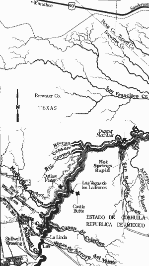
Stillwell Crossing to Langtry (Including the Lower Canyons)
135 Miles
Stillwell Crossing to Langtry (Including the Lower Canyons)
(135 miles)
The Lower Canyons of the Rio Grande are located in Brewster, Terrell, and Val Verde Counties. This 135-mile section of the river passes through extremely scenic, wild, and remote country. Many people consider the Lower Canyons to be the third wildest river canyon in the U. S., ranking only behind the Grande Canyon of the Colorado River in Arizona and Hells Canyon of the Snake River in Idaho. Therefore, recreational use of the Lower Canyon should be attempted only by an experienced outdoorsman.
Almost the entire section consists of deep canyons. Once inside these canyons, there is virtually no way out except to climb and hike over miles of rugged desert terrain. Many excellent rapids are found on this section. At normal and high water levels several of these rapids become extremely hazardous and a few have to be portaged even at low levels.
Water levels on this section are normally adequate for recreational use, but the best levels are 4 to 5 feet, as reported from the Big Bend Gaging Station. During periods of heavy rainfall, flash floods are common, and there have been reports of tremendous walls of water rushing through some of the side canyons. Therefore, campsites should be high above the river. There are numerous grassy banks and sand bars present which lend themselves to camping and day use.
Access to the river is extremely difficult because of the remoteness of the region and lack of development. Stillwell Crossing, a river ford on the U. J. Adams Ranch; and the bridge crossing at La Linda, are the most popular access points. In both cases, advance permission needs to be obtained from the owners before the crossings can be utilized. A good alternative to these crossings is located on the Black Gap Wildlife Management Area at the mouth of Maravillas Creek where a road goes down to the river. This shortens the section by 12 miles. Recreationists need to check in at the headquarters area.

Rio Grande River
Lower Canyons, Continued
Rio Grande River
Lower Canyons, Continued
Major Waterways features (only generally located because of a lack of exact maps) and distance between each are as follows:
Stillwell Crossing - A river ford on the U. J. Adams Ranch. The crossing can be
reached from Marathon by taking U.S. Highway 385 toward Big Bend National Park,
then FM 2627 through Black Gap Wildlife Management Area. The road to the crossing
follows Stillwell Creek.
Stillwell Creek - Located just downstream from the river road. (0.0 mile)
La Linda Crossing - The bridge is located at the end of FM 2627 and is believed
to be owned by the DuPont Chemical Company. (2 miles)
Horse Canyon - A short but very deep canyon. From this canyon to immediately
downstream from Big Canyon on the Texas side is the Black Gap Wildlife
Management Area. (3 miles)
Maravillas Canyon - Aroad from Black Gap Headquarters leads down to Maravillas
Creek where good access to the river is available. (9 miles)
Las Vegas de los Ladrones (Outlaw Flats) - These vegas, or flatlands, are found
on both sides of the river. (7 miles)
Castle Butte - Sometimes called "El Capitan". This is an outstanding landmark, a huge,
flat-topped butte that rises about one thousand feet above the desert floor. (2 miles)
Big Canyon - A large canyon entering from the Texas side marks the turn of the river as it
starts flowing to the east. The remains of an old partially hidden cabin exist on the
Texas side. Warm springs and some rapids are found. (5 miles)
Reagan Canyon - A side canyon from Texas is marked by a spectacular rise of wall.
An old stone cabin on the Texas side exists. The river canyon, for approximately
40 miles downstream, is known as Reagan Canyon, Bullis Canyon, or
Canyon de Lleguas. (1 mile)
San Rocendo Canyon - A large canyon enters from Mexico. A couple of adobe houses
exist above the canyon on top of the hill. (0.5 mile)
Dagger Mountain (Loma de las Palmas) - A mountain on the Texas side, across from
San Rocendo Canyon. (0.0 mile)
Hot Springs Rapid - Located at the base of San Rocendo Canyon, formed by boulder
outwashes from the Canyon. The rapid requires a portage in most situations. (0.0 mile)
Hot spring - Located about 50 yards below Hot Springs Rapid on the Mexican side.
This is a place to replenish drinking water. (0.0 mile)
Burro Bluff - A high sheer bluff on the Texas side. (14 miles)
Burro Bluff Rapids or Upper Madison Falls - Located at the base of Burro Bluff.
These rapids come in two parts, the upper section, which is passable, and the
lower section, which is virtually impassable, located about 200 feet below the first.
Both sections should be portaged. (0.0 mile)
Horseshoe Falls or Lower Madison Falls - Located about 3 or 4 miles below Burro Bluff.
A horseshoe shaped barrier has been created by a rockfall, and a portage is required.
(4 miles)
Hot Springs - Several hot springs are found in the vicinity of Horseshoe or
Lower Madison Falls. (0.0 mile)
Panther Canyon - A side canyon entering from Texas with several large caves in the
canyon walls. (2.5 miles)
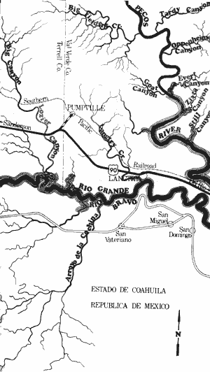
Rio Grande River
Lower Canyons, Continued
Rio Grande River
Lower Canyons, Continued
Panther Canyon Rapid - A very challenging
rapid located at the mouth of Panther
Canyon. This rapid is passable under
most conditions. (0.0 mile)
San Francisco Canyon - This is a very
wide canyon that enters from the Texas
side. (5.5 miles)
San Francisco Canyon Rapids - Excellent
rapids located at the mouth of San
Francisco Canyon. The current sweeps
against the side of the canyon wall, and
extreme caution needs to be exercised
when running the rapid. (0.0 mile)
Sanderson Canyon - A large canyon entering
from the Texas side. (12 miles)
Large rapid - Located a few miles downstream from Sanderson Canyon. This
rapid requires a portage in some
situations. (2.5 miles)
Dryden crossing - an old cable crossing,
located at the Dryden Crossing once
crossed the river. Presently only some
ladders and remains of old buildings
exist on the site. A Texaco sign is
located on the banks, and a private
camp is available. (1.5 miles)
Shafter Crossing - A ford located just
upstream from Shafter Canyon. A
primitive dirt road leads to Dryden.
(3 miles)
El Indio Canyon - a sheer canyon that is
approximately 8 miles long. (4 miles)
Lozier Canyon - enters from the Texas side.
The walls of the canyons begin to lower
at this point. (24 miles)
Langtry - This small community is located
up on a hill on the Texas side. A dirt
road comes within about one-half mile
of the river. (23 miles)
Amistad Dam to Gulf of Mexico
(Not mapped)
500 miles
This section of the Rio Grande, from Amistad Dam to Falcon Reservoir and from Falcon Dam to the Gulf of Mexico, flows through decreasingly rugged county as it nears the coast. The arid, desert-type environment present in the vicinity of Del Rio soon gives way to semi-arid brush lands and finally to the semi-tropical regions of deep South Texas. This entire section is available for recreational use at any time of the year since there is always sufficient water.
As the river meanders slowly through the brush country of South Texas, the quality of water deteriorates. Numerous villages, towns, and cities are located along the river, all of which contribute to the deteriorating water quality. The scenery continues to be dominated by high bluffs and mesas below Amistad Reservoir. These bluff and small canyons gradually decrease until only flat semi-arid brushlands, typical of South Texas, are found. Vegetation becomes dense and lush as the river nears the Gulf of Mexico.
As the river meanders slowly through the brush country of South Texas, the quality of water deteriorates. Numerous villages, towns, and cities are located along the river, all of which contribute to the deteriorating water quality. The scenery continues to be dominated by high bluffs and mesas below Amistad Reservoir. These bluff and small canyons gradually decrease until only flat semi-arid brushlands, typical of South Texas, are found. Vegetation becomes dense and lush as the river nears the Gulf of Mexico.
Top of Page | Table of Contents