- Table of Contents
- Foreword
- Introduction
- Texas Waterway Map
- Map Key
- East Texas Waterways
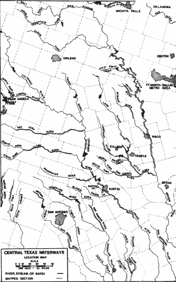
- Central Texas Waterways
- Major Waterways:
- Blanco River
- Bosque River
- Brazos River
- Colorado River
- Concho River
- Frio River
- Guadalupe River
- Lampasas River
- Lavaca River
- Leon River
- Little River
- Llano River
- Medina River
- Navidad River
- Nueces River
- Paluxy River
- Pedernales River
- San Antonio River
- San Bernard River
- San Gabriel River
- San Marcos River
- San Saba River
- Wichita River
- Seasonal and Restrictive Waterways
- Major Waterways:
- West Texas Waterways
An Analysis of Texas Waterways
A Report on the Physical Characteristics of Rivers, Streams, and Bayous in Texas
Major Waterways of Central Texas
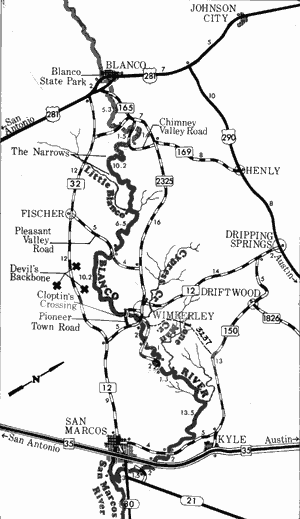
Blanco River
Blanco River
This section contains maps and an analysis of the more popular and scenic sections of the rivers and streams in Central Texas and short verbal descriptions of other sections on these same waterways. Central Texas waterways are characterized by swiftly-moving and oftentimes shallow waters, occasional rapids, many outcroppings of rock and outstanding scenic qualities.
The Blanco River rises in northeast Kendall County, then flows approximately 87 miles southeast through Blanco and Hays Counties, where it joins the San Marcos River. The upper section of the Blanco is noted for containing historic Indian mounds are unusual geologic formations. The lower section passes between bald cypress lined banks and through areas of scenic beauty. For most of its length the river remains shallow and recreational use is feasible only for those sections where water has backed up behind low water dams. However, during periods of heavy run-off, the Blanco retains good water levels for recreational use. The feasibility of the Blanco for recreational use by the public may be limited since, for the most part, the streambed is privately owned. Interesting rapids and swift water are present for the entire length.
River Road to Farm-to-Market 165
(Not mapped)
23 miles
The Blanco River in Kendall and Blanco Counties is a narrow and extremely shallow waterway. The river essentially consists of long, shallow stretches flowing over a limestone bottom. Occasionally, a deep pool of water will be found. Since the river flows over limestone, the water is high quality and clear. Limestone bluffs and bald cypress trees line the banks. Several small check dams are constructed on this section, particularly in the vicinity of Blanco. During periods of runoff, this section is a potentially good recreational waterway, but under normal water levels would be insufficient for recreational use. Blanco State Park, located on the river in Blanco, can be utilized as an access point and campground for trips on this section, or it could be an alternate access point for a trip downstream from Blanco.
Blanco River
Farm-to-Market 165 to the San Marcos River
64 Miles
Farm-to-Market 165 to the San Marcos River
64 miles
The Blanco River in Blanco and Hays Counties flows through some of the most interesting scenery in Central Texas. The river continues to flow over a bed of limestone and the banks are lined with bald cypress, pecan, willow, and sycamore trees, while the hills away from the river are covered with live oaks and cedars. Numerous outcroppings of rocks and bluffs are present. Two noteworthy landmarks are "the narrows" and "Devil's Backbone". The narrows is an area where the river is constricted between steep bluffs while the Devil's Backbone is an extensive area of rugged, hilly country located adjacent to the river.
The river normally is extremely shallow for several miles below Blanco, until sufficient spring and creek inflows increase the water level in the vicinity of Devil's Backbone near Wimberly. Normal water levels often prove too shallow for good recreational usage upstream from Devil's Backbone. More suitable water levels are found downstream from Wimberly. During periods of heavy rainfall, the Blanco is an excellent recreational waterway, containing numerous rapids and providing a route to view outstanding Hill Country scenery. Several small check dams, which must be portaged, are located on the river. The Cloptins Crossing area, located approximately 2 miles upstream from Wimberly, is being considered as the site for a major reservoir which would inundate several miles of river upstream. Waterway features and distance between each are as follows:
FM 165 crossing - one mile east of Blanco.
Small dam - a portage is required. (1.3 miles)
Small dam - a portage is required. (0.5 mile)
Cox Road Crossing - county road, 4.5 miles east
of Blanco. (3.5 miles)
Chimney Valley Road Crossing - county road,
5 miles east of Blanco. (1.5 miles)
Chimney Valley Road Crossing - county road,
6 miles east of Blanco. (1.6 miles)
The Narrows - the river becomes constricted
between steep bluffs. (7.5 miles)
Little Blanco River - enters on the right. This
tributary adds a large volume of water to the
flow of the Blanco. (2.7 miles)
Small dam - located just upstream from
Pleasant Valley Crossing. (6 miles)
Pleasant Valley Crossing - county road off
FM 2325, 6 miles east of Wimberly.
(0.5 mile)
Devil's Backbone - Dominant hills rising
several hundred feet above the river on the
right. (6 miles)
Cloptins Crossing - a river ford located 2 miles
south west of Wimberly. (3.5 miles)
Pioneer Town Crossing - county road 1 mile
southwest of Wimberly at the community
of Pioneer Town. (0.7 mile)
Cypress Creek - enters on the left. This creek
has its origins in historic "Jacob's Well",
which supplies a large volume of water for
the creek and river. (1 mile)
FM 12 crossing - one-half mile southeast of
Wimberly. (0.5 mile)
County road crossing - located just downstream
from FM 12. (0.1 mile)
County road crossing - 2 miles east of
Wimberly. (2 miles)
County road crossing - 3 miles east of
Wimberly. (3 miles)
County road crossing - 4 miles east of
Wimberly. (4 miles)
Long Man Creek - enters on the left. (1.5 miles)
County road crossing - off IH 35, 4 miles
northeast of San Marcos. (13.5 miles)
IH 35 crossing - 2 miles northeast of San
Marcos. (2 miles)
County road crossing - off FM 21, 1 mile east
of San Marcos. (2 miles)
SH 80 crossing - one mile east of San
Marcos. (1.5 mile)
San Marcos River - the Blanco River joins
the San Marcos River approximately three
miles downstream from SH 80. (3 miles)
Bosque River
The Bosque River rises in northern Erath County and flows approximately 115 miles southeast through Hamilton, Bosque, and McLennan Counties to join the Brazos River at Waco. One reservoir, Lake Waco, is located on the river in McLennan County. The Bosque flows through a rolling hills terrain, with post oak and cedar dominating the vegetation of the country side. The river is a perennially flowing stream, but its suitability for recreational use is restricted during dry periods. Potential hazards to recreationists are confined to occasional overhanging limbs or trees.
State Highway 108 to Iredell
(Not mapped)
42 miles
The Bosque River in its upper reaches in Erath, Hamilton, and Bosque Counties is a relatively narrow, free-flowing stream. The river is scenic, lined with heavily vegetated banks and contains clear water. However, in several places, the waterway is too shallow for recreational use at normal water levels. During periods of heavy rainfall, this section is potentially a good recreational waterway.
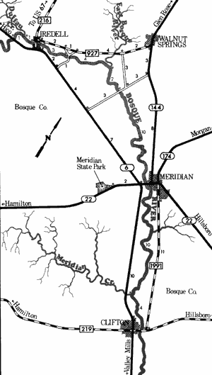
Bosque River
Iredell to Clifton
35 Miles
Iredell to Clifton
35 miles
This 35-mile section of the Bosque River in Bosque County is lined with scenic vegetated banks of pecan, sycamore, elm, and cottonwood. Clear water of good quality flows over a rock and sand bottom. A few fast stretches and shoal areas exist but are not hazardous to recreational use. The river is not very wide and does not normally have a large flow. Several stretches are too shallow for recreational use at normal water levels. When rainfall is plentiful, this stretch of the Bosque is noted as an excellent recreational waterway that has few hazards. Although access is provided at numerous points along this section, the best point for beginning recreational use is at State Highway 6 crossing, 2 miles west of Iredell. Waterway features and distance between each are as follows:
SH 6 crossing - 2 miles west of Iredell. Poor
access is available.
Duffau Creek - enters on the left. (1 mile)
FM 216 crossing - in Iredell. Poor access is
available. (1 mile)
County road crossing - 2 miles east of Iredell
off FM 927. About 700 feet of shoreline and
a small parking area are available. (3 miles)
East Bosque River - enters on the left. (4 miles)
County road crossing - between SH 6 and
SH 144, 6 miles east of Iredell. (2 miles)
SH 22 crossing - located in Meridian. About
200 feet of shoreline and a small parking
area are available. (10 miles)
Meridian Creek - enters on the right. (10 miles)
FM 219 crossing - located on the eastern edge
of Clifton. About 200 feet of shoreline is
available and picnic tables are provided.
(4 miles)
Clifton to Waco
(Not mapped)
34 miles
The Bosque River along this section flows into the Brazos River near Waco. One impoundment, Lake Waco, is located on this section. The water above the reservoir deepens considerably and recreational usage is possible at all times. Below Lake Waco Dam, the river depends upon water releases before recreational usage is feasible. The river below the dam usually has a large volume of water, because of the existence of Lake Brazos, located below the confluence of the Bosque with the Brazos. This is an extremely scenic section, particularly in the vicinity of the confluence of the two rivers, where Cameron City Park in Waco is located.
Top of Page | Table of Contents