- Table of Contents
- Foreword
- Introduction
- Texas Waterway Map
- Map Key
- East Texas Waterways
- Central Texas Waterways
- Major Waterways:
- Blanco River
- Bosque River
- Brazos River
- Colorado River
- Concho River
- Frio River
- Guadalupe River
- Lampasas River
- Lavaca River
- Leon River
- Little River
- Llano River
- Medina River
- Navidad River
- Nueces River
- Paluxy River
- Pedernales River
- San Antonio River
- San Bernard River
- San Gabriel River
- San Marcos River
- San Saba River
- Wichita River
- Seasonal and Restrictive Waterways
- Major Waterways:
- West Texas Waterways
An Analysis of Texas Waterways
A Report on the Physical Characteristics of Rivers, Streams, and Bayous in Texas
Major Waterways of East Texas
San Jacinto River, West Fork
The San Jacinto River has its beginnings in its East and West Forks in San Jacinto and Walker Counties, respectively. The two forks then flow into northeastern Harris County where they merge to form the main stream. The main stream is dammed just below the confluence of its two forks, forming Lake Houston. The lower section of the main stream constitutes a portion of the Houston Ship Channel. The West Fork is dammed in Montgomery County, creating Lake Conroe. Both forks of the San Jacinto have limited flows of water, and recreational usage depends upon sufficient rainfall to increase the volume of water. The main stream is infeasible as a recreational waterway.
State Highway 30 to Lake Conroe
(Not mapped)
15 miles
The West Fork of the San Jacinto River, above Lake Conroe, is extremely narrow and has a limited flow of water. Under normal conditions, water levels are too shallow for recreational activities. Even during periods of heavy rainfall when water levels are up, the narrow width of the river and presence of overhanging branches result in navigational difficulties. However, the river is scenic; since it is located in the vicinity of Sam Houston National Forest.

San Jacinto River
State Highway 105 to US 59
34 Miles
State Highway 105 to US 59
34 miles
This 34-mile section of the West Fork of the San Jacinto River is located in Montgomery and Harris Counties. This stretch is located immediately below Lake Conroe Dam and recreational usage depends upon sufficient water releases from the dam. The dam does not have a set generating schedule or a minimum daily release; therefore, times exist when the river has only a small volume of water. When the dam is releasing, particularly in the spring and fall, recreational use is possible. Although the river is very narrow and some problems with overhanging brush are found, water quality is good. The river flows through scenic pine and hardwood bottomlands, and a float trip at the proper time would be most rewarding. Waterway features and distance between each are as follows:
SH 105 crossing - 4 miles west of Conroe.
FM 2854 crossing - 3 miles west of Conroe. About 400 yards of shoreline are available on the highway right-of-way. (3 miles)
Lake Creek - enters on the right. (5 miles)
IH 45 crossing - 4 miles south of Conroe. (3 miles)
Little Caney Creek-enters on the left. (4 miles)
Crystal Creek - enters on the left. (3 miles)
Spring Creek - enters on the right. (15 miles)
US 59 crossing - located on the northeastern city limit of Humble. (1 mile)
Private Camp - located immediately downstream from US 59 on the left bank with picnicking facilities available.
Private Camp - located immediately downstream from US 59 on the right bank with picnicking facilities available.
Lake Houston - is located immediately downstream.
Sulphur River
(Not mapped)
The Sulphur River is formed in east Delta County by the union of its North and South Forks and flows through Bowie, Morris, and Cass Counties into the Red River in Arkansas. Approximately 75 miles of the main stream are located in Texas. Flowing through heavily timbered woods where little or no current is present, the water is generally muddy due to channelization upstream. No rapids are present. Lake Texarkana is located on the Sulphur, and recreational use of the section below the dam depends upon water releases from the dam. The portion above the reservoir contains sufficient water for recreational activities almost any time. The section below the dam has the best water quality.
Waterway features are as follows: US 259 crossing - fifteen miles southeast of De Kalb and eight miles north of Omaha, US 67 crossing - six miles southwest of Bassett and seven miles northwest of Marietta, SH 8 crossing - four miles south of Maud and four miles north of Douglassville. (Lake Texarkana is immediately below this site), and US 59 crossing - one-half below Lake Texarkana Dam, ten miles north of Queen City and eight miles southwest of Texarkana. The Texas-Arkansas State Line is located about seventeen miles below this site. No further road crossings are located in Texas.
Trinity River
The Trinity River has its beginnings in four forks - the East Fork in Grayson County, the Elm Fork in Montague County, the West Fork in Archer County, and the Clear Fork in Parker County. The main stream begins at the junction of the Elm and West Forks in Dallas. The entire length of the Trinity totals 550 miles, most of which can be utilized for recreational purposes.
Characteristic of the Trinity is its large number of meanders, resulting in hazardous log jams at numerous bends, particularly between Dallas and Lake Livingston. The river banks above Lake Livingston are usually steep and muddy, but become gently sloping and composed of sand below Livingston Dam.
Clear Fork
Parker and Tarrant Counties
The Clear Fork of the Trinity River in Parker and Tarrant Counties is feasible for recreational use both above and below Benbrook Reservoir. The river above the dam from the town of Aledo to Highway 377 totals 15 miles in length, and can be floated during periods of high water flow. The stream along this section is predominantly narrow and shallow. Here, steep banks are present and the river has a sand and gravel bottom. The optimum water flow for recreational use below the dam is reported to be 140 cubic feet per second (CFS). A greater release rate could produce hazardous conditions for float trips. A scenic, heavily wooded four-mile stretch between the park below the dam and Loop 820 can be utilized for recreational purposes. One dam encountered on this stretch could be dangerous unless portaged. There are many fast channels which provide excitement for recreationists.
West Fork
Archer, Jack, Wise, Tarrant and Dallas Counties
Formed in southern Archer County, the West Fork of the Trinity River flows southeast for approximately 145 miles to join with the Clear Fork in Fort Worth. Three reservoirs-Lake Bridgeport, Eagle Mountain Lake, and Lake Worth, are located at various intervals along the West Fork. During periods when water is being released from the dams, the West Fork may have potential for recreational use. Reportedly, the best section for such purposes lies below Lake Worth where the Clear Fork joins the West Fork. The river along this stretch is relatively narrow with steep muddy banks and occasional log jams which could prove hazardous. The major recreational significance of the West Fork is that it is located within the confines of a major metropolitan area yet retains its natural qualities and scenic character.
East Fork
Rockwall and Kaufman Counties
The East Fork of the Trinity River flows 78 miles through Grayson, Collin, Rockwall, Dallas, and Kaufman Counties. Here, the river rambles through typical wooded bottomlands of post oak, elm, ash, and pecan. Two reservoirs are located on the East Fork - Lavon Lake and Lake Ray Hubbard. Lavon Lake is located in Collin County and Lake Ray Hubbard is located in Dallas, Kaufman, and Rockwall Counties. Depending upon the amount of water being released from Ray Hubbard Dam, the 40-mile stretch between Interstate Highway 20 and Highway 34 has potential for recreational use. However, the last 20 to 25 miles is reportedly the best section for recreational float trips.
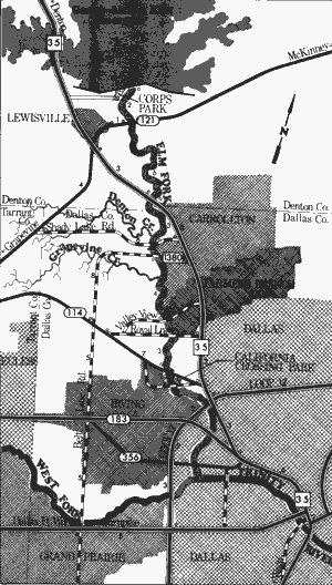
Trinity River, Elm Fork Garza
Little Elm Reservoir to California Crossing Park
22 Miles
Trinity River, Elm Fork
Formed in Montague County, the Elm Fork of the Trinity River flows approximately 85 miles southeast meeting the West Fork to create the main stream of the Trinity. Garza-Little Elm Reservoir (Lake Dallas) is located on the Elm Fork. The 22-mile section below the dam can be floated since there are sufficient water releases from the dam at all times.
Garza-Little Elm Reservoir to California Crossing Park
22 miles
The Elm Fork which receives intensive usage by recreationists, flows through the densely populated Dallas Metropolitan Area. Along the fork, two small dams have been constructed downstream from IH 35. Here, the flood plain, which is flat and over one-half mile wide in some places, has been stripped of most of its native vegetation. The river's main asset is the fact that it is a relatively remote waterway with good recreational potential located in a huge metropolitan area.
Water quality of the Elm Fork is good since it issues from the bottom of Garza-Little Elm Reservoir. Flowing from the reservoir, the first 6 to 8 miles have moving currents, but the remainder of this segment contains still water because of the small dams. Flowing through a heavily timbered strip of elm, oak, and willow; Elm Fork meanders by several public parks. Potential hazardous log jams are present, although the Dallas municipal water authorities attempt to keep the river unobstructed. Elm Fork is easily accessible because of the many road crossings and parks. Waterway features and distance between each are as follows:
Corps of Engineers park - located immediately
below Lewisville Dam.
SH 121 crossing - 1 mile east of Lewisville.
(2 miles)
IH 35 crossing - 3 miles southeast of Lewisville.
(6 miles)
Denton Creek - enters on the right.
Shady Lake Road crossing - off IH 35, in the
western city limit of Carrollton. (3 miles)
Small dam - located immediately downstream
from Shady Lake Road crossing. A portage
is required. (0.5 mile)
Belt Line Road crossing (FM 1380) - off IH 35,
in the western city limit of Carrollton.
(0.5 mile)
Grapevine Creek - enters on the right.
Valley View Road crossing - off IH 35, in the
western city limit of Farmers Branch.
(4 miles)
Royal Lane crossing- off IH 35, in the south-western city limit of Farmers Branch.
(2.5 miles)
SH 114 crossing - off IH 35, in the northwestern
city limit of Dallas. (3 miles)
Small dam - located immediately below
SH 114. A portage is required. (0.5 mile)
California Crossing Park - located on the left
bank, adjacent to the above mentioned
dam. Elm fork can be floated down to its
confluence with the West Fork, and the
trip can be continued on the main stream.
Top of Page | Table of Contents