- Table of Contents
- Foreword
- Introduction
- Texas Waterway Map
- Map Key
- East Texas Waterways
- Central Texas Waterways
- Major Waterways:
- Blanco River
- Bosque River
- Brazos River
- Colorado River
- Concho River
- Frio River
- Guadalupe River
- Lampasas River
- Lavaca River
- Leon River
- Little River
- Llano River
- Medina River
- Navidad River
- Nueces River
- Paluxy River
- Pedernales River
- San Antonio River
- San Bernard River
- San Gabriel River
- San Marcos River
- San Saba River
- Wichita River
- Seasonal and Restrictive Waterways
- Major Waterways:
- West Texas Waterways
An Analysis of Texas Waterways
A Report on the Physical Characteristics of Rivers, Streams, and Bayous in Texas
Major Waterways of Central Texas
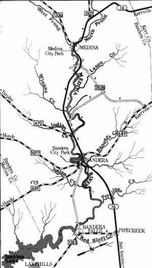
Medina River
Totaling in length approximately 116 miles, the Medina River is formed in northwest Bandera County and flows southeast through Medina and Bexar Counties where it joins the San Antonio River. One major reservoir, Lake Medina, is formed by the river in Bandera and Medina Counties. The Medina is spring-fed and is a typical Hill Country river, containing crystal clear waters, bald cypress lined banks, and limestone outcroppings. It is a small river with an average width of approximately 30 to 40 feet. However, since the Medina has its origins in springs, it normally has a sufficient flow of water for recreational use. The section of river above Lake Medina contains the best recreational conditions, since the river is narrow, overgrown, and often shallow below the dam.
Medina River
Medina City Park to Bandera Falls
27 Miles
Medina City Park to Bandera Falls
27.6 miles
This 38-mile section of the Medina River flows through a scenic portion of the Hill Country in Bandera County. A small but beautiful stream, the Medina contains crystal clear water, bald cypress trees with Spanish moss, and many limestone outcroppings. Here, the water flows swiftly over a limestone bottom and numerous small rapids exist. Providing caution is exercised, none of these rapids are potentially dangerous. Since the Medina has its origins in springs, it normally has a steady flow of water; however, the water level can drop considerably and cause the river to become extremely shallow during the dry summer months.
There are no potentially dangerous places along this stretch at normal water levels. The river is readily accessible because of numerous road crossings, a few roadside and city parks, and private camps. Camping areas are a problem since only a few small sand and gravel bars exist. Waterway features and distance between each are as follows:
Moffett Park - City park located on the west side of the city of
Medina. Approximately 100 feet of shoreline are available.
County road crossing - off SH 16, 3 miles east of Medina. (2 miles)
SH 16 crossing - 4 miles east of Medina. (1 mile)
Private camp - off SH 16, 8 miles
west of Bandera. About 2 miles
of shoreline are available.
Facilities for camping and
picnicking are provided. (4 miles)
County road crossing - off SH 16,
5 miles east of Bandera.
(1 mile)
SH 16 crossing - 3 miles west of
Bandera. A roadside park
provides about 100 feet of
shoreline. (4 miles)
FM 470 crossing - 3 miles west of
Bandera. A roadside park
provides about 100 feet of
shoreline. (0.5 mile)
Hudspeth Park - City park located
in the southwest sector of
Bandera provides approximately
one-fourth mile of shoreline. A
low water dam has formed a
small lake at this point. (5 miles)
FM 689 crossing - in the city of
Bandera. A road goes down
beneath the bridge. This
crossing is located immediately
downstream from the city park
and dam. (0.1 mile)
County road crossing - 1 mile
northwest of Bandera Falls.
This low water crossing provides
good access, but cars have to
be parked on top of the hill.
(11 miles)
Private camp - located 1 mile
south of Bandera Falls
approximately 100 yards up
Red Bluff Creek. Camping and
picnicking facilities are available.
(1 mile) Immediately downstream
is Lake Medina.
Medina Diversion Reservoir to San Antonio River
(Not mapped)
64 miles
The Medina River below Lake Medina is a slower moving, meandering stream. Here, the waterway is relatively narrow and shallow, and the water quality is far below what is found above Lake Medina. There are no rapids, and log jams choke off the river in places. The river banks are heavily vegetated with hardwood bottomlands of oak, pecan, sycamore, and elm; along with water hyacinths and cattails growing in the streambed. There are numerous road crossings which divide the river into segments ranging in length from one-half mile to five miles. Conditions that would encourage extensive recreational use of this section of the Medina usually are not present.
Navidad River
The Navidad River rises 2 miles northeast of Schulenburg in southeast Fayette County and flows approximately 90 miles through Lavaca, Colorado, and Jackson Counties joining the Lavaca River near Vanderbilt. The Navidad River is very much like its counterpart, the Lavaca River, in that its watershed is very limited, and it depends entirely upon runoff for its flow. Therefore, the Navidad is suitable for recreational use only during periods of sufficient rainfall. The lower section in the vicinity of Edna usually contains a substantial flow and recreational use is possible. The river flows through the coastal plains, and no major hazards are found.
Farm-to-Market 532 to Morales Crossing
(Not mapped)
45 miles
The Navidad River along its upper course is basically an intermittent stream because the river is not spring-fed. These upper reaches are extremely narrow, and many log jams exist which may cause hazardous navigation for recreationists. However, during periods of heavy rainfall when flooding conditions are present, the upper reaches have limited potential for recreational use.
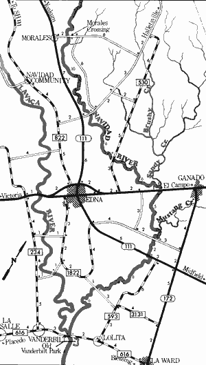
Navidad River
Morales Crossing to Old Vanderbilt Park
43.5 Miles
Morales Crossing to Old Vanderbilt Park
43.5 miles
This 43.5-mile section of the Navidad River runs parallel to and never more than 10 miles from the Lavaca River. The Navidad River is a coastal river, meandering slowly through the coastal plains. Here vegetation along the river consists of coastal hardwoods. Log and brush jams frequently exist causing navigational difficulty.
Reportedly, the remains of an old steamer are located at the junction of the two rivers. The Navidad does not have a large flow of water, yet the heavy rains associated with the coastal plains normally provide sufficient water levels along this section for recreational use. Waterway features and distance between each are as follows:
Morales crossing - county road
crossing off SH 111, 11 miles
northwest of Edna.
County road crossing - off SH 111,
6 miles north of Edna. (10 miles)
FM 530 crossing - 3 miles north of
Edna. (6 miles)
Sandy Creek - enters on the left.
US 59 crossing - 5 miles northeast
of Edna. A roadside park exists
along the river. (6 miles)
Mustang Creek - enters on the left.
County road crossing - off SH 172,
5 miles south of Ganado.
(5 miles)
SH 111 crossing - 6 miles south
of Ganado and 6 miles east of
Edna. (2 miles)
County road crossing - between
FM 1822 and FM 593, 8 miles
southeast of Edna. Good access
is available. (8 miles)
FM 616 crossing - 2 miles west of
Lolita. (6 miles)
Old Vanderbilt Park - on the Lavaca
River, 2 miles east of Vanderbilt.
(0.5 mile)
Nueces River
The Nueces River rises in its east fork in northwestern Real County and flows southeastward for approximately 315 miles into the Gulf of Mexico. The Nueces is a clear spring-fed stream flowing through scenic canyons until it issues from the Balcones Escarpment in northern Uvalde County. The river then flows through the semi-arid ranching country until it reaches the Coastal Plains. Upon reaching the Plains, the Nueces gains a larger flow of water.
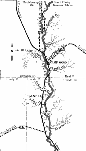
Nueces River
Farm-to-Market 335 to State Highway 55
45 Miles
Farm-to-Market 335 to State Highway 55
45 miles
This 45-mile section of the Nueces River in Real, Edwards, and Uvalde Counties is one of the more picturesque rivers in the State. The spring-fed Nueces is crystal clear and flows through limestone bluffs of the Edwards Plateau. These bluffs have created small canyons through which the river twists and turns. At normal water levels, the river contains intermittent pools followed by long stretches of shallow, swift water. During low water periods, recreational use of the Nueces is difficult; however, usage appears feasible when the river is on a slight rise. During high water periods, numerous rapids exist, some of which may be hazardous. Several spring-fed creeks enter the river along this stretch, insuring that a steady flow, although somewhat shallow, is always maintained.
Plant materials vary from pecans, oaks, and cedars, associated with the Edwards Plateau, to semi-arid plants of sagebrush, mesquite, and cacti. As the river enters Uvalde County, the Hill Country begins to diminish and the harsher ranch lands of South Texas appear. Access points are numerous, since there are several road crossings and private camps along the river. Waterway features and distance between each are as follows:
Private camp - located just below the juncture of Hackberry Creek
and the East Prong of the Nueces River, 18 miles north of
Camp Wood off FM 335. Camping facilities are available.
FM 335 crossing - 16 miles north of Camp Wood. The river is shallow
and wide, But deep pools are evident above and below the
crossing. (2 miles)
Private camp - 14 miles north of Camp Wood, off FM 335.
One mile of shoreline and camping facilities are available. (2 miles)
FM 335 crossing - 10 miles north of Camp Wood. (4 miles)
Private camp - 10 miles north of Camp Wood, off FM 335.
Camping facilities are available. (1 mile)
Private camp - 5 miles north of Camp
Wood, off SH 55, 1 mile east of
Barksdale. This is actually a ford,
and the river becomes wide and
shallow. (0.5 mile)
SH 55 crossing - 1 mile southeast of
Barksdale. Good access is
available on the highway right-of-way. (1 mile)
Private camp - off SH 55, just north
of Camp Wood. Camping facilities
are available. (3 miles)
Nueces Lake Park - 4 miles south
of Camp Wood. A concession
stand and camping facilities are
available. (5 miles)
SH 55 crossing - 5 miles south of
Camp Wood. Good access is
available on the highway right-of-way. (1 mile)
County road crossing - off SH 55,
6 miles south of Camp Wood.
(3 miles)
County road crossing - off SH 55,
24 miles northwest of Uvalde.
(4 miles)
County road crossing - off SH 55,
21 miles northwest of Uvalde.
(7 miles)
County road crossing - off SH 55,
19 miles northwest of Uvalde.
(2 miles)
County road crossing - off SH 55,
17 miles northwest of Uvalde.
(2 miles)
SH 55 crossing - 15 miles northwest
of Uvalde. (3 miles)
State Highway 55 to Nueces Bay
(Not mapped)
300 miles
The Nueces River below SH 55 in Uvalde County issues from the Balcones Escarpment and meanders through the semi-arid lands of Uvalde, Zavala, Dimmit, LaSalle, McMullen, Live Oak, San Patricio, and Nueces Counties in South Texas. The river is shallow and except during high water conditions, this section is not suitable for recreational use. However, in the vicinity of Three Rivers, where the Frio and Atascosa Rivers join the Nueces, the flow of water increases, and recreational usage becomes feasible. The river at this point becomes a coastal river, flowing through relatively flat coastal plains. Lake Corpus Christi is located on the Nueces approximately 40 miles upstream from Nueces Bay.
Top of Page | Table of Contents