- Table of Contents
- Foreword
- Introduction
- Texas Waterway Map
- Map Key
- East Texas Waterways
- Central Texas Waterways
- Major Waterways:
- Blanco River
- Bosque River
- Brazos River
- Colorado River
- Concho River
- Frio River
- Guadalupe River
- Lampasas River
- Lavaca River
- Leon River
- Little River
- Llano River
- Medina River
- Navidad River
- Nueces River
- Paluxy River
- Pedernales River
- San Antonio River
- San Bernard River
- San Gabriel River
- San Marcos River
- San Saba River
- Wichita River
- Seasonal and Restrictive Waterways
- Major Waterways:
- West Texas Waterways
An Analysis of Texas Waterways
A Report on the Physical Characteristics of Rivers, Streams, and Bayous in Texas
Major Waterways of East Texas
Neches River
Formed in Van Zandt County of East Texas, the Neches River flows southeast for approximately 416 miles and empties into the Gulf of Mexico near Port Neches. A drainage area of 10,011 square miles and abundant rainfall over the entire Neches Basin results in a flow near the Gulf of approximately 6,000,000 acre-feet per year. The river runs most of its course through piney woods. Two major reservoirs are located on the Neches. Lake Palestine is located near the headwaters of the river in Henderson, Smith, Cherokee, and Anderson Counties; and B. A. Steinhagen Lake is located on the lower section in Tyler and Jasper counties. A small reservoir, Rhine Lake, is located above Lake Palestine. The river between Rhine Lake, Lake Palestine, and immediately below Lake Palestine has a limited flow and recreational usage is restricted to periods of heavy rainfall. However, the flow increases downstream and provides adequate water for recreational use. Occasional log jams in the upper reaches of the Neches serve to hinder full use of the river by recreationists.
Rhine Lake Dam to State Highway 21
(Not mapped)
108 miles
The upper reaches of the Neches River in Van Zandt, Smith, Henderson, Cherokee, Anderson, Houston, Angelina, Trinity, and Polk Counties, flow through typical East Texas pine and hardwood bottomlands. Here, the river is scenic and an abundance of wildlife can be sighted on the banks. The only prevailing hazards found along this section are occasional log jams. From Rhine Lake to Lake Palestine (40 miles) the Neches is extremely narrow and shallow, rendering recreational usage infeasible. Along the upper reaches, the best areas for recreational activities are found below Lake Palestine Dam. Sufficient water releases from the dam result in adequate conditions for recreational use of the river downstream. The best sections are: 1) a 24.5 mile section between US 175 crossing (10 miles northwest of Jacksonville) and US 84 crossing (14 miles west of Rusk). Approximately one-half mile of shoreline is reportedly available to the public on the highway right-of-way at US 175. 2) a 17-mile trip from Brick Smith crossing (10 miles south of Maydelle in Cherokee County) to SH 21 crossing (8 miles southwest of Alto, between Cherokee and Houston Counties.). About one mile of river is reportedly available to the public on the road right-of-way at Brick Smith crossing; and 100 yards of highway right-of-way is available at SH 21 crossing.
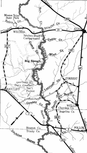
Neches River
State Highway 21 to State Highway 7
32 Miles
State Highway 21 to State Highway 7
Big Slough Trip
32 miles
This 32-mile section of the Neches, forming the partial boundary between Cherokee and Houston Counties, is a scenic and popular waterway. Located adjacent to the river on the right bank are portions of Davy Crockett National Forest containing a wide variety of vegetative types, including oak, hickory, and pine. The Neches River is wide, free-flowing, and has maintained its natural character. The only potential hazards to be found are occasional log jams. This section has considerable merit for recreational activities due to the existence of the Big Slough, a small channel which goes off from the Neches then returns to the river about 4 miles downstream, thereby creating a loop waterway of approximately 8 miles. The Big Slough, contained wholly within Davy Crockett National Forest, and the Neches River, adjacent to the National Forest, have been marked as a loop canoe trail by the U.S. Forest Service. In addition, the U.S. Forest Service considers the Big Slough area a potential wilderness area.
Water levels for recreational activities are sufficient year round on the Neches; however, the drier summer months result in a reduction of water flow in Big Slough. In general, this section of the Neches is scenic and of high quality for recreational activities. Waterway features and distance between each are as follows:
SH 21 crossing-8 miles southwest of Alto and 5 miles northeast of Neches. About 100 yards of shoreline are available on the highway right-of-way.
Neches Bluff campground - A U.S. Forest Service campground is located on a tall bluff on the right bank. Camping facilities are available. Forest Road 511, off SH 21, leads to the campground. (1 mile)
Cedar Creek - enters on the left. (2 miles) Camp Creek - enters on the right. (6 miles) Wire Creek - enters on the left. (1 mile)
Big Slough - forms on the right. A dirt road off Forest Road 511 leads down to Big Slough. (1 mile)
Big slough enters on the right. (4 miles)
Larrison Creek - enters on the left. (9 miles)
County Road crossing - off FM 1247, 6 miles south of Forest and 8 miles northeast of Ratcliff. (0.5 mile)
Conner Creek - enters on the right. (4 miles)
Devils Bayou - enters on the left. (2 miles)
SH 7 and SH 103 crossing - 26 miles east of Crockett and 7 miles southeast of Pollock.
(2.5 miles)
Neches River
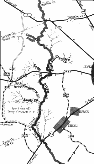
State Highway 7 to US Highway 59
42 Miles
State Highway 7 to US Highway 59
42 miles
Forming the partial boundary of Houston, Angelina, Trinity, and Polk Counties, this 42-mile section of the Neches River is very remote, due largely to the scarcity of road crossings. Portions of Davy Crockett National Forest are located on the right bank. The river is extremely scenic, flowing through a forest of cypress, oak, sweetgum, and pine. The water is rather murky in appearance, but maintains sufficient quality to meet minimum standards for contact sports. Water levels are sufficient for recreational activities on a year round basis; however, the summer months are usually characterized by a considerable reduction in flow that restricts some recreational use. The river moves slowly and log jams are prevalent in many sections. Camping facilities available in Davy Crockett National Forest aid in making this section of the Neches River a quality waterway for recreational use. Waterway features and distance between each are as follows:
SH7 crossing - 26 miles east of Crockett and 13 miles southwest of Lufkin.
Cochino Bayou - enters on the right. TPWD boat ramp (6 miles)
Crawford Bayou - enters on the left. (7 miles)
SH 94 crossing - 8 miles west of Lufkin. (5 miles)
Cedar Creek - enters on the right. (2 miles)
Hackberry Creek - enters on the right. (9 miles)
Alabama Creek Wildlife Management Area - 8 miles northeast of Apple Springs. A public park is located within 200 feet of the river. Reportedly, camping is permitted. (1 mile)
US 59 crossing - 3 miles south of Diboll. A Wildlife boat ramp is located on the Polk County side. (12 miles)
Neches River
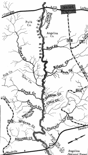
US Highway 59 to US Highway 69
44 Miles
US Highway 59 to US Highway 69
44 miles
Offering scenic float trips through pristine southern floodplain forest, this 44-mile section of the Neches River forms the boundary between Polk, Angelina, Tyler, and Jasper Counties. This stretch is extremely isolated since there are no road crossings other than the two US highways. Portions of the adjacent lands on the east bank, from the Jasper-Angelina County line to US 69, are under the administration of the U.S. Forest Service. The river varies in width from 75-150 feet, and adequate water is available at all times for recreational use. Log jams are likely to be found along with 5 or 6 rocky shoal areas. Numerous sand bars which often lend themselves to camping and day use are located at various intervals. This section of the Neches River is a quality recreational waterway. Waterway features and distance between each are as follows:
US 59 crossing - 3 miles southwest of Diboll. A Texas Parks & Wildlife boat ramp is located on the Polk County side.
Dollarhide Cutoff - begins on the left. (0.5 mile)
Dollarhide Cutoff - re-enters the main stream. (4 miles)
Bear Creek - enters on the left. (5.5 miles)
Biloxi Creek - enters on the left. (7 miles)
Buck Creek - enters on the left. (1 mile)
Piney Creek - enters on the right. (4 miles)
Caney Creek - enters on the right. (4 miles)
Loggins Creek - enters on the left. (1 mile)
Russell Creek - enters on the right. (4 miles)
Clear Creek - enters on the left. (1 mile)
Shawnee Creek - enters on the left. Site of old Fort Teran and an old ferry crossing are located on the banks at this point. (5 miles)
McGraw Creek - enters on the right. (3 miles)
Billiams Creek - enters on the right. (1 mile)
US 69 crossing - 18 miles north of Woodville. (3 miles) This is the last road crossing above
B. A. Steinhagen Reservoir. A small waterfall
is located approximately 4 miles below US 69.
Portions of the east bank downstream from
US 69 are administered by the U.S. Forest
Service. Bouton Lake Recreation Area in
Angelina National Forest is located adjacent
to the river and is reached via SH 63 and
Forest Service Road 303.
Neches River
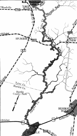
B.A. Steinhagen Lake to US Highway 96
54 Miles
B. A. Steinhagen Reservoir to US Highway 96
54 miles
One of the more popular and scenic waterways in the State, this 54-mile section of the Neches River forms the boundary between Jasper, Tyler, and Hardin Counties. In general, the water runs deep along this section when the dam is releasing. However, there is sufficient water in the river for recreational activities even when no water is being released. The average stream width along this section is approximately 150 to 200 feet. Abundant with wildlife, this area is scenic, containing numerous cypress swamps intermixed with pine, and hardwood forests. No particular hazards or danger points exist. Large sand bars are prevalent and lend themselves to camping and day use. There are only two road crossings on this 54-mile stretch, making the area relatively isolated. Waterway features and distance between each are as follows:
Road off FM 1746 in Town Bluff - immediately below the dam. The road goes down to the river bank and a private camp is located at this point.
Walnut Run - enters on the left. (3 miles)
Old Sheffield Crossing -FM 1013 crossing, 5 miles east of Spurger. A Texas Parks and Wildlife boat ramp is available for use. (9 miles)
Hardin County Park - located on Camp Craven Road off SH 92, northeast of Slisbee. Camping facilities are available. (32 miles)
US 96 crossing - 1 mile west of Evadale. A Texas Parks & Wildlife boat ramp is available for use. (10 miles)
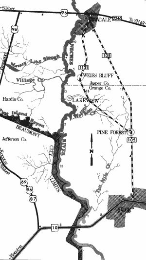
Neches River
US Highway 96 to Interstate Highway 10
39 Miles
US Highway 96 to Interstate Highway 10
39 miles
This 39-mile section of the Neches River, forming the boundary between Jasper, Hardin, Jefferson, and Orange Counties, flows very deep and wide, always having sufficient water for recreational activities. The area through which it flows consists of scenic cypress swamps and hardwood forests. Many species of wildlife are often seen. Large, white sand bars which are often utilized for camping and day use are spaced periodically. Potential hazards are virtually non-existent. The city limits of Beaumont extend to the river on the lower portion of this section, and some residential development is found. This section is a very popular and scenic stretch. Waterway features and distance between each are as follows:
US 96 crossing - one mile west of Evadale. A Texas Parks & Wildlife boat ramp is available for use.
Massey Lake Slough - enters on the right. (10 miles)
Village Creek - enters on the right. This is an extremely scenic creek which has potential
for recreational use. (5 miles)
Public Boat ramp - located in the Lakeview development. (2 miles)
Walnut Run Creek - enters on the left. (5 miles)
Pine Island Bayou - enters on the right. This creek is very beautiful and has potential for recreational use. (2 miles)
Ten Mile Creek - enters on the left. (13 miles)
IH 10 crossing - eastern city limit of Beaumont. Below this point, the river becomes extremely wide, since it is open to ocean-going vessels. Access to the river is very difficult on the highway right-of-way. (2 miles)
Top of Page | Table of Contents