- Table of Contents
- Foreword
- Introduction
- Texas Waterway Map
- Map Key
- East Texas Waterways
- Central Texas Waterways
- Major Waterways:
- Blanco River
- Bosque River
- Brazos River
- Colorado River
- Concho River
- Frio River
- Guadalupe River
- Lampasas River
- Lavaca River
- Leon River
- Little River
- Llano River
- Medina River
- Navidad River
- Nueces River
- Paluxy River
- Pedernales River
- San Antonio River
- San Bernard River
- San Gabriel River
- San Marcos River
- San Saba River
- Wichita River
- Seasonal and Restrictive Waterways
- Major Waterways:
- West Texas Waterways
An Analysis of Texas Waterways
A Report on the Physical Characteristics of Rivers, Streams, and Bayous in Texas
Major Waterways of Central Texas
Concho River
The Concho River, formed in San Angelo by the confluence of its North and South Forks, flows 24 miles through Tom Green County, then 29 miles through Concho County where it joins the Colorado River 12 miles northeast of Paint Rock. The river flows predominantly through rolling hills and semi-arid ranch and farm land. The Concho is scenic, containing many small limestone outcroppings and vegetation consisting of mesquite, willow, elm, pecan, yucca, cacti, and grasses. Three major reservoirs are located on the three upper forks of the Concho. These reservoirs regulate the flow of the main stream.
North Fork
Tom Green County
The North Fork of the Concho River from San Angelo Dam to Bell Street City Park in San Angelo is an 8-mile stretch which is suitable for recreational use when the dam is releasing water. The South Concho joins the North Concho at Bell Street Park to form the main stream. Above San Angelo Reservoir, the North Fork is intermittent.
South Fork
Tom Green County
The South Concho River is perennially flowing, spring-fed stream. However, Twin Buttes Reservoir and Lake Nasworthy restrict the natural flow. When Lake Nasworthy Dam is releasing water, the South Concho is sometimes suitable for recreational use from the dam to Bell Street City Park in San Angelo, where it joins the North Fork and forms the main Concho River. Recreational use continues down the main stream. The South Fork also is suitable for recreational use a short distance above Twin Buttes Reservoir where "slack water" or still water is created by the lake.
Main Stream
South Concho Park to Farm-to-Market 1692
(Not mapped)
18 miles
The upper section of the main stream of the Concho River, from South Concho Park in San Angelo to FM 1692, is scenic, containing high, steep banks lined with elm, willow, and mesquite. Here, the river is shallow and narrow, yet a minimum amount of water for recreational use is available at all times. There are two low water dams on this section which pose some problems to use of the river. Access to the river is no problem because of the existence of several parks, particularly South Concho City Park in San Angelo and two county parks at downstream low water crossings. Scenery that is typical of the semi-arid ranch and farm country in this locale is seen as the river moves downstream.
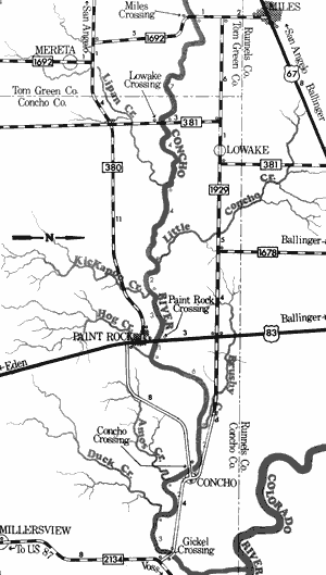
Concho River
Farm-to-Market 1692 to Gickel Crossing
35 Miles
Farm-to-Market 1692 to Gickel Crossing
35 miles
This 35-mile section of the Concho River in Tom Green and Concho Counties is a small but unique type of waterway, flowing through semi-arid farm and ranch land. These semi-arid conditions are depicted along the banks of the Concho as evidenced by the frequent occurrence of mesquite, yucca, and cacti.
The river is relatively narrow and at normal levels is shallow; however, a minimum amount of water for recreational use exists on a year round basis. Extended periods of dry weather would reduce the suitability of the river for recreational use. A few small rapids and swift area are found, but no major rapids are present. The major problems to recreationists are several small dams and low water crossings which create deep, still water above them and require a portage. Waterway features distance between each, and conditions of the river at these points are as follows:
FM 1692 crossing (Miles Crossing) - 12 miles
northeast of San Angelo. A small county
park is located on the south bank. There
is good access, the stream is 30 feet
wide upstream and 10 feet wide
downstream.
FM 381 crossing (Lowake Crossing) - 11
miles west of Paint Rock. Access is
completely fenced off. The stream is
10 feet wide and very shallow. (7 miles)
Lipan Creek - enters on the right. (4 miles)
Little Concho Creek - enters on the left.
(4 miles)
Kickapoo Creek - enters on the right.
(2 miles)
US 83 crossing (Paint Rock Crossing) -
located in Paint Rock. Access at the
highway is poor; however, a low water
crossing approximately 100 yards
downstream provides good access.
An old city park and swimming pool
once existed here, but are no longer
functional. A low water dam is located
between the low water crossing and the
highway. (3 miles)
Hog Creek - enters on the right. (1 mile)
Brushy Creek - enters on the left. (6 miles)
County road crossing (Concho Crossing) -
off FM 1929, 7 miles northeast of Paint
Rock. There is good access and the river
is wide and deep above the crossing, but
shallow and narrow below the crossing.
(2 miles)
Amos Creek - enters on the right. (2 miles)
Duck Creek - enters on the right. (2 miles)
County road crossing (Gickel Crossing) -
off FM 2134, 11 miles east of Paint
Rock. There is good access and the
river is wide and deep above the
crossing, but shallow and narrow
below the crossing. (3 miles)
About one mile downstream, the Concho
River joins the Colorado River.
Frio River
The Frio River rises in northeast Real County and flows southeast through Uvalde, Medina, Frio, La Salle, and Live Oak Counties. Totaling in length approximately 250 miles, the Frio is spring-fed in its upper section and flows through picturesque canyons. Garner State Park is located on the banks of this upper section. The waterway is a free-flowing river, since there are no major impoundments or reservoirs located along its entire course.
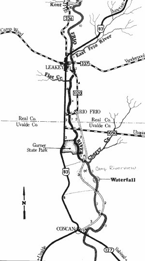
Frio River
Kent Creek to Concan
31 Miles
Kent Creek to Concan
31 miles
This 31-mile section of the Frio River in Real and Uvalde Counties is one of the most scenic section of river in the State. The river forms in springs just north of Kent Creek, with many additional springs located along this upper stretch, as well as in Kent Creek. The width of the stream is generally very narrow, and water flow at normal levels is relatively low, approximately 100 cubic feet per second (CFS). However, adequate water for recreational use is available especially when the river is on a rise. Many shallow but excellent rapids and an occasional low water dam are found.
The banks of the waterway are lined with bald cypress, pecans, and oaks, while cedar and live oak-covered hills rise above the river. Picturesque canyons are formed by limestone outcroppings and bluffs. Few sand or gravel bars are found; however, Garner State Park and several private camps are available for camping. Several roads cross the river and provide good access. Waterway features and distance between each are as follows:
County road crossing - 9 miles north of
Leakey, just upstream from Kent Creek.
Kent Creek - enters on the right. (1 mile)
US 83 crossing - 1 mile north of Leakey.
(9 miles)
East Frio River - enters on the left.
(0.5 mile)
FM 337 crossing - 1 mile east of Leakey.
(1.5 mile)
Private camp -1 mile south of Leakey,
off FM 1120. About 1 mile of shoreline
and camping facilities are available.
Private camp - 2 miles south of Leakey,
off FM 1120. About 0.5 miles of
shoreline and camping facilities are
available.
FM 1120 crossing - 1 mile south of Leakey.
(2 miles)
Flat Creek - enters on the right. (1 mile)
FM 1120 crossing - at Rio Frio. (3 miles)
FM 1050 crossing - 24 miles north of
Uvalde. (2 miles)
Garner State Park - off US 83, 22 miles
north of Uvalde. A low water dam is
located within the park. Camping
facilities are available. (1.5 miles)
Magers Crossing - off FM 1050, 20 miles
north of Uvalde. (1.5 miles)
Cherry Creek - enters on the left. (0.5 mile)
Private camp - below Garner State Park.
Camping facilities are available. (0.5 mile)
Waterfall - located approximately 4 miles
below the dam at Garner State Park.
This waterfall is passable during high water, but extreme caution must be
exercised. (1.5 miles)
County road crossing - off SH 127, 5 miles
northwest of Concan. (1 mile)
County road crossing - off SH 127, 3 miles
northwest of Concan. (2 miles)
Concan to Nueces River
(Not mapped)
217 miles
Flowing through semi-arid ranching country, the Frio River below the town of Concan at times, is completely dry. During periods of heavy rainfall, the river consists of deep pools interspersed between very shallow areas. The normal average water flow below the confluence with the Dry Frio is only 20.5 cubic feet per second (CFS), while the river is usually dry at Uvalde. Semi-arid conditions exist throughout most of the river's entire course until it reaches the vicinity of Three Rivers, where the Frio joins the Atascosa and Nueces River. Adequate water for recreational use is found below the confluence of the three rivers. In general, the lower sections of the Frio are not suitable for recreational use except during flood conditions, and then they become hazardous for most recreational activities.
Top of Page | Table of Contents