- Table of Contents
- Foreword
- Introduction
- Texas Waterway Map
- Map Key
- East Texas Waterways
- Central Texas Waterways
- Major Waterways:
- Blanco River
- Bosque River
- Brazos River
- Colorado River
- Concho River
- Frio River
- Guadalupe River
- Lampasas River
- Lavaca River
- Leon River
- Little River
- Llano River
- Medina River
- Navidad River
- Nueces River
- Paluxy River
- Pedernales River
- San Antonio River
- San Bernard River
- San Gabriel River
- San Marcos River
- San Saba River
- Wichita River
- Seasonal and Restrictive Waterways
- Major Waterways:
- West Texas Waterways
An Analysis of Texas Waterways
A Report on the Physical Characteristics of Rivers, Streams, and Bayous in Texas
Major Waterways of East Texas

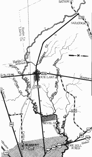
Pine Island Bayou
Farm-to-Market 770 to US Highways 96, 287, & 69
49 Miles
Pine Island Bayou
Pine Island Bayou rises in eastern Liberty County and flows southeast through Hardin County where it empties into the Neches River. Flowing through the Big Thicket country for approximately 25 miles, Pine Island Bayou is remote and retains a truly wilderness character. The lower part forms the northern boundary of the Beaumont City Limit and some development exists. The bayou is a beautiful, slow-running stream consisting of cypress swamps, pine and hardwood forests. Five units of the proposed String of Pearls concept for establishing a Big Thicket National Park are located along Pine Island Bayou.
Farm-to-Market 770 to US 96, 287, and 69
49 miles
This section of Pine Island Bayou forms the boundary between Hardin and Jefferson Counties. The bayou is an extremely scenic and popular waterway, flowing through the southern confines of the Big Thicket. The almost impenetrable thicket holds a remarkably wide variety of plant life, which, in turn, provides excellent cover for many wildlife species. Much of this plant and animal life is rare or endangered (a few are almost extinct), thus nature is in delicate balance throughout this area. Many of the spectacular features of the Big Thicket can be seen along Pine Island Bayou.
The bayou itself is scenic. Clear waters flow over white sand and gravel, with periodic sand and gravel bars providing areas which often lend themselves to camping and day use. The bayou is very narrow, and overhanging brush and limbs are a problem to recreationists. No hazardous areas are found on the bayou. Water levels are sufficient for recreational use at any time. During periods of extremely high water, the main channel is very hard to distinguish while floating the bayou. The summer months can be uncomfortable due to heat and insects. The lower portion of the bayou forms the northern boundary of Beaumont's city limits. However, little development is observed from the bayou. Waterway features and distance between each are as follows:
FM 770 crossing - 2 miles southwest of Saratoga.
Jackson Creek - enters on the left. (18 miles)
Willow Creek - enters on the right. (3 miles)
SH 326 crossing - 2 miles south of Sour Lake. (0.5 mile)
Carlton Creek - enters on the right. (7 miles)
County road crossing - off Calder Lane in Beaumont, 3 miles southeast of Sour Lake. The road slopes gently to the bayou. (0.5 mile)
SH 105 crossing - 6 miles east of Sour Lake. The road slopes gently to the bayou. (7 miles)
Little Pine Island Bayou - enters on the left. (3 miles)
Black Creek - enters on the left. (7 miles)
US 96, 287, and 69 crossing - located on the northwest city limit of Beaumont. A boat ramp is provided. (3 miles)
Eight miles downstream from the previous crossing, Pine Island Bayou flows into the Neches River.
Red River
(Not mapped)
The Red River, which borders Hardeman, Wilbarger, Wichita, Clay, Montague, Cooke, Fannin, Lamar, Red River, and Bowie Counties, is the second largest river associated with Texas. Even though the river forms a major Texas boundary, it is considered to belong wholly to Oklahoma. For this reason, the Red River has not been investigated in-depth by the Texas Parks and Wildlife Department. However, because of the Red River's proximity to Texas population centers, it must be considered a major recreation resource for Texans.
Above Clay County the Red River is seasonal, and recreational use is feasible only during periods of heavy run-off. Reportedly, the following points of access for this section are: SH 30 crossing - 21 miles northwest of Quanah, SH 283 crossing - 7 miles north of Quanah, US 283 crossing - 18 miles north of Quanah, US 183 and US 70 crossing - 12 miles northeast of Vernon, and US 277 and US 281 crossing - 14 miles north of Wichita Falls.
The Wichita River flows into the Red River in Clay County. From this junction to Lake Texoma, the Red River is feasible for recreational activities year round. Quicksand is common to this stretch and is a limiting factor to recreational use. The following points of access have been reported for this section: SH 79 crossing - 20 miles north of Henrietta, US 81 crossing - 12 miles northwest of Nocona, and IH 35 and US 77 crossing - 6 miles north of Gainesville.
The Red River is a popular recreational waterway from below Lake Texoma near Denison, Texas, to the Arkansas border near Texarkana; especially when Denison Dam is generating. In the summer months, Denison Dam usually releases water for power generation on the weekends. The river is most feasible for recreational use when the crest of the water release from the dam is caught. This provides good floating to the Texas-Arkansas Line.
The Red River from Denison Dam to Arkansas flows through remote, rugged, wild country, with few points of access available. From Lamar County, eastward, recreational use is feasible almost all year long. The following points of access have been reported for the Denison Dam to the Arkansas section: US 75 and 69 crossing - 4 miles north of Denison, SH 78 crossing - 10 miles north of Bonham, US 271 crossing - 14 miles north of Paris, SH 37 crossing - 16 miles north of Clarksville, US 259 crossing - 13 miles north of DeKalb, and US 59 & US 71 crossing - 6 miles north of Texarkana.
Sabine River
The two upper forks of the Sabine River, the South and Cowleech Forks, are formed in eastern Collin County and northwestern Hunt County respectively. These two forks meet in Hunt County forming the main stream which flows southeast through pine woods for approximately 555 miles, partially forming the boundary between Texas and Louisiana. The river then empties into the Gulf of Mexico at Sabine Lake. The Sabine has the largest volume of water discharged (approximately 6,800,000 acre-feet) at its mouth of any river in Texas. The word "Sabine" comes from the Spanish word for "cypress," referring to the stately trees which line the banks of the river.
Two large reservoirs have been constructed on the Sabine. Lake Tawakoni in Hunt, Rains, and Van Zandt Counties, is a water storage reservoir which largely controls the upper portion of the river. Lake Tawakoni has been constructed at the junction of the South and Cowleech Forks. Toledo Bend Reservoir, a huge impoundment located along the Texas and Louisiana border, controls the lower Sabine River.
Lake Tawakoni Dam to State Highway 42
(Not mapped)
130 miles
The South and Cowleech Forks of the Sabine River above Lake Tawakoni do not have sufficient water for recreation use. Both forks are extremely narrow containing many log jams, which may be hazardous to navigation. Below Lake Tawakoni, recreational activities are seasonal, depending upon water releases from Lake Tawakoni Dam. The Lake is a water storage reservoir and water is released only when the lake level exceeds conservation pool. The river below the dam is scenic, but also is extremely narrow, rendering overhanging branches and log jams as a problem to recreationists.

Sabine River
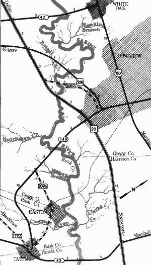
State Highway 42 to State Highway 43
44.5 Miles
State Highway 42 to State Highway 43
44.5 miles
This scenic, 45-mile section of the Sabine River forms the boundary of Rusk, Gregg, Harrison, and Panola Counties. An enlarged drainage area contributes significantly to the flow of water in the river at this point and recreational usage is feasible almost any time. Wide and slow-moving, the Sabine is characterized by occasional log jams and a large variety of plant and animal life. Several sand bars which would lend themselves to camping and day use are available. And a few shoal areas, among which are Watson Shals and Massive Rock Crossing, are present. In addition, a small 2-3 foot waterfall is located below SH 42. Numerous oil derricks, remnants of a bygone era, are standing in the riverbed throughout this section. Here, the river is presently receiving a large amount of pollution from the surrounding metro areas. However, this section of the Sabine River could become a high quality recreational attraction to Northeast Texas if a solution to this problem could be found. Waterway features and distance between each are as follows:
SH 42 crossing - 2 miles south of White Oak. About 200 feet of shoreline are available on the highway right-of-way.
Waterfall - a small 2-3 foot fall spans the width of the river. (2 miles)
Hawkins Branch - enters on the left. (3 miles)
US 259 crossing - 2 miles southwest of Longview. Approximately 500 feet of shoreline are
available on the highway right-of-way.
Rabbit Creek - enters on the right. (2.5 miles)
FM 2087 crossing - 3 miles southwest of Longview. Approximately 300 feet of shoreline are available on the highway right-of-way. (0.5 mile)
IH 20 crossing - 3 miles south of Longview. Access would be poor. (2 miles)
Dutchman Creek - enters on the right. (4.5 miles)
SH 149 crossing - 3 miles south of Longview. 200 feet of shoreline are available on the highway right-of-way. (1.5 miles)
Massey Branch - enters on the right. (4 miles)
Cherokee Bayou - enters on the right. (10 miles)
Clarks Creek - enters on the left. (0.5 mile)
SH 43 crossing - 5 miles northeast of Tatum. A boat ramp is available on the road right-of-way. (7 miles)

Sabine River
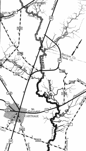
State Highway 43 to Farm-to-Market 2517
41 Miles
State Highway 43 to Farm-to-Market 2517
41 miles
Scenic and little developed along its banks, this 41-mile stretch of the Sabine River is located on Harrison and Panola Counties. Vegetation is widely varied, ranging from giant cypress to pines and various hardwoods. The Sabine is fed by several creeks and bayous along this section and an abundance of wildlife exists along the southern flood plain forest.
The water flow along this section is sufficient to support recreational usage at any time of the year. The water quality continues to be affected by pollution from upstream metro areas, but the cleansing action of flowing water has greatly improved the quality of this section.
One area of interest exists a mile or so below SH 43, where black coal has been uncovered near the river. In addition, a small 2-3 foot waterfall is located downstream from US 79. Here, an occasional log jam is found which may prove hazardous to navigation. Sand bars which are often utilized for camping and day use are plentiful. This section of the Sabine could become a high quality recreation attraction to Northeast Texas if the upstream pollution problem can be controlled. Waterway features and distance between each are as follows:
SH 43 crossing - 5 miles northeast of Tatum.
Potters Creek -enters on the left. (5 miles)
US 59 crossing - 11 miles north of Carthage. About 100 yards of shoreline are available on the highway right-of-way. (6 miles)
Eight Mile Creek - enters on the left. (1 mile)
FM 1794 crossing - 8 miles north of Carthage. (5 miles)
Martin Creek - enters on the right. (2 miles)
Jackson Creek - enters on the left. (9.5 miles)
US 79 crossing - 7 miles northeast of Carthage. A Texas Parks and Wildlife boat ramp is
available. (0.5 mile)
Waterfall - a small 2-3 foot waterfall spans the width of the river. Mill Creek-enters on the left. (4 miles)
FM 2517 crossing - 8 miles southeast of Carthage. A Texas Parks and Wildlife boat ramp is available. This is the last road crossing above Toledo Bend Reservoir. (8 miles)

Sabine River
Toledo Bend Dam to US 190
56 Miles
Toledo Bend Dam to US 190
56 miles
This 56-mile section of the Sabine River partially forms the boundary line between Texas and Louisiana. Here, the river is approximately 75 - 100 feet wide and slow-moving, taking on a swampy appearance, with enormous cypress trees lining each bank. Reportedly, Toledo Bend Reservoir maintains an almost continuous release of water. Therefore, adequate water levels for recreational use exist almost constantly. In addition, the quality of water is excellent from the dam to Orange.
This study has found that this extremely scenic section of river, with the swampy terrain that exists throughout much of the area, serves as a habitat for a wide variety of wildlife species. Hazards on the river are virtually non-existent with the exception of one small waterfall located about 3 miles below the dam. Many fine white sand bars which are often utilized as camping and day use areas are present. The river is very isolated since only three roads cross it along this stretch. This section of the Sabine River is one of the more scenic, quality waterways in the State. Waterway features and distance between each are as follows:
FM 692 crossing - immediately below Toledo Bend Dam. A small dirt road lends down to the river below the spillway.
Waterfall - a very small waterfall is located approximately 3 miles below the dam. (3 miles)
Hurger Branch - enters on the right. (7 miles)
Hickman Creek - enters on the right. (2 miles)
SH 63 crossing - 11 miles northeast of Burkeville. The river is approximately 150 feet wide at this point. (5 miles)
Mill Creek - enters on the right. (2 miles)
Detty Creek - enters on the right. (8 miles)
Little Cow Creek - enters on the right. (10 miles)
Dirt road - off FM 1414, at the mouth of Little Cow Creek. This area, reportedly, is open
to the public.
US 190 crossing - 2 miles east of Bon Wier. The river is approximately 150 feet wide and extremely scenic with steep banks present beneath the bridge. (19 miles)

Sabine River
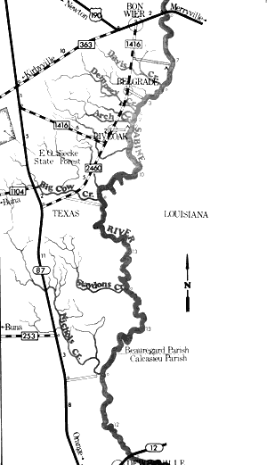
US Highway 190 to State Highway 12
60 Miles
US Highway 190 to State Highway 12
60 miles
This 60-mile section of the Sabine River is very similar to the section immediately above it. The river partially forms the boundary lines between Texas and Louisiana and is very isolated since only two roads cross the entire 60-mile stretch. Wide and extremely scenic, the Sabine takes on a swamp-like appearance having huge cypress trees covered with Spanish moss as common elements of the riverscape. This area provides habitat for a wide variety of wildlife.
The Sabine River has an adequate flow of water to permit recreational usage during most of the year. The river is slow-moving, deep, and virtually no potential hazardous places are to be found. There are numerous sand bars which are often utilized for camping and day use. The scenic beauty and extreme isolation of this section of the Sabine creates a very desirable recreational waterway with many creeks and bayous providing further adventure in the surrounding forests. Waterway features and distance between each are as follows:
US 190 crossing - 2 miles east of Bon Wier. The river is approximately 150 feet wide and extremely scenic with steep banks present beneath the bridge.
County road - off FM 1416, 3 miles south of Bon Wier. This area is reportedly, open to the
public. (5 miles)
Davis Creek - enters on the right. (2 miles)
County road - off FM 1416, 2 miles east of Belgrade. The road dead ends at the river and steep banks are present.
Dempsey Creek - enters on the right. (3 miles)
Arch Creek - enters on the right. (2 miles)
County road - 2 miles east of Live Oak, off FM 1416. This area, reportedly, is open to the public.
Big Cow Creek - enters on the right. (13 miles)
County road - off FM 1416, 4 miles south of Live Oak. The road goes to the mouth of Big Cow
Creek, then follows the river for some distance.
Slaydons Creek - enters on the right. (13 miles)
Nichols Creek - enters on the right. (13 miles)
County road - off SH 87, 10 miles north of Deweyville. The road goes to the mouth of Nichols Creek where a boat ramp is available.
SH 12 crossing - 1 mile east of Deweyville. (12 miles)
State Highway 12 to the Gulf of Mexico
(Not mapped)
37 miles
This section of the Sabine River in Newton and Orange Counties is feasible for recreational use at all times. In the vicinity of Interstate Highway 10 crossing, the river is approximately 300 feet wide. Below IH 10, the river is deep enough to allow passage of ocean-going vessels. The scenic qualities are very good from SH 12 to IH 10. Some development is present in the immediate vicinity of Orange.
Top of Page | Table of Contents