- Table of Contents
- Foreword
- Introduction
- Texas Waterway Map
- Map Key
- East Texas Waterways
- Central Texas Waterways
- Major Waterways:
- Blanco River
- Bosque River
- Brazos River
- Colorado River
- Concho River
- Frio River
- Guadalupe River
- Lampasas River
- Lavaca River
- Leon River
- Little River
- Llano River
- Medina River
- Navidad River
- Nueces River
- Paluxy River
- Pedernales River
- San Antonio River
- San Bernard River
- San Gabriel River
- San Marcos River
- San Saba River
- Wichita River
- Seasonal and Restrictive Waterways
- Major Waterways:
- West Texas Waterways
An Analysis of Texas Waterways
A Report on the Physical Characteristics of Rivers, Streams, and Bayous in Texas
Major Waterways of East Texas
Village Creek
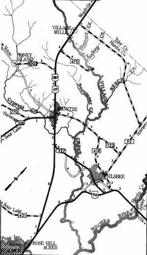
Village Creek, formed in northwestern Hardin County, joins with Big Sandy Creek then flows southeast where it meets the Neches River near Silsbee. This creek is a free-flowing stream which passes through the heart of the Big Thicket. The stream flows through cypress swamps and pine and hardwood forests. Because of its remoteness, outstanding scenic qualities, and lack of impoundments, Village Creek retains its wild and pristine characteristics.

Village Creek
US Highway 69 and US Highway 287 to US Highway 96
37 Miles
US Highway 69 and US Highway 287 to US Highway 96
37 miles
This 37-mile section of Village Creek is located in Hardin County between the towns of Village Mills and Silsbee. Consisting of still or slow-moving water, the creek is normally 20 to 30 feet wide and is characterized by overhanging brush, limbs, and an occasional log jam. This section of Village Creek provides an exciting float trip through a dense forest cover typical of the Big Thicket.
This section of Village Creek is noted for its outstanding scenery. Large bald cypress trees and fresh water swamps exist just yards back from the creek. Clear waters of the creek flow over white sand and gravel, and sand bars which often lend themselves to camping and day use are present. The almost impenetrable thicket bordering the creek holds a remarkably wide variety of plant life, much of which is rare or endangered. In much of this area, nature is in very delicate balance and should be carefully protected. Water levels are sufficient for recreational use at any time, although the drier summer months cause a substantial reduction in flow. These summer months are often uncomfortable to recreationists because of heat and insects. Waterway features and distance between each are as follows:
US 69 and 287 crossing - 8 miles north
of Kountze.
Private land - this land belonging to Kirby
Lumber Company, reportedly, is open
to the public. Approximately 2 miles
of shoreline are available on the right
bank. (0.1 mile)
Hickory Creek - enters on the left.
(4 miles)
Turkey Creek - enters on the left.
(1 mile)
FM 470 crossing - off US 287 and 69,
5 miles north of Kountze. (1 mile)
Beech Creek - enters on the left. (8 miles)
Beaumont Creek - enters on the right.
(5 miles)
FM 418 crossing - between Kountze and
Silsbee. 100 yards of shoreline are
available on the highway right-of-way.
(1 mile)
Cypress Creek - enters on the right.
(4 miles)
SH 327 crossing - 2 miles west of
Silsbee. 200 yards of shoreline
are available on the highway right-of-way. (4 miles)
County road crossing - off SH 327,
2 miles southwest of Silsbee.
(2 miles)
US 96 crossing - 4 miles south of
Silsbee. A Texas Parks and
Wildlife boat ramp is provided.
(7 miles)
About 6 miles downstream Village
Creek flows into the Neches River.
Top of Page | Table of Contents